
FCCInfo.com
A Service of Cavell, Mertz & Associates, Inc.
(855) FCC-INFO
|
|
WTMO-CD from 02/09/2007 WTMO-CD from 06/09/1999 WTMO-CD from 09/13/1990 WTMO-CD from 05/11/1987 |
|  |
|
|||||||||||||||
|
|
Repacking Information: No changes Status: License Application Accepted: 08/15/2011 License Expires: 02/01/2021 File Number: BLDTA-20110815ACQ Prefix Type: This is BLDTA FCC Website Links: LMS Facility Details This Application Other WTMO-CD Applications Including Superseded Applications Mailing Address Correspondence for WTMO-CD Correspondence related to application BLDTA-20110815ACQ Service Contour - Open Street Map or USGS Map (51 dBu) Service Contour - KML / Google Earth (51 dBu) Public Inspection Files Rabbit Ears Info Search for WTMO-CD Site Location: 28-36-22.6 N 81-27-23.9 W (NAD 83) Site Location: 28-36-21.6 N 81-27-24.6 W (Converted to NAD 27) ERP: 15 kW R/C AGL: 123.1 m (404 ft.) R/C AMSL: 156 m (512 ft.) Emission Mask: Stringent Site Elevation: 32.9 m. (108 ft.) Height Overall*: 155.1 m (509 ft.) (* As Filed In This Application, may differ from ASR Data, Below.) Directional Antenna - Antenna Make/Model: Antenna Concepts Inc. ACS24BR Antenna ID: 17753 | ||||||||||||||||||
| Antenna Data for Antenna Id: 17753 WTMO-CD DC File: BLDTA-20110815ACQ Antenna Concepts Inc. - ACS24BR Service: DC Standard Pattern: Y Pattern and Field Values Include a 135° Clockwise Rotation | 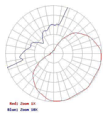 | ||||||||||||||||||
| Azimuth | Ratio | Azimuth | Ratio | Azimuth | Ratio | Azimuth | Ratio | ||||||||||||
| 5 | 0.060 | 15 | 0.080 | 25 | 0.230 | 35 | 0.400 | ||||||||||||
| 45 | 0.600 | 55 | 0.710 | 65 | 0.820 | 75 | 0.890 | ||||||||||||
| 85 | 0.970 | 95 | 0.990 | 105 | 1.000 | 115 | 0.980 | ||||||||||||
| 125 | 0.980 | 135 | 1.000 | 145 | 0.980 | 155 | 0.980 | ||||||||||||
| 165 | 1.000 | 175 | 0.990 | 185 | 0.970 | 195 | 0.890 | ||||||||||||
| 205 | 0.820 | 215 | 0.710 | 225 | 0.600 | 235 | 0.400 | ||||||||||||
| 245 | 0.230 | 255 | 0.080 | 265 | 0.070 | 275 | 0.060 | ||||||||||||
| 285 | 0.050 | 295 | 0.050 | 305 | 0.040 | 315 | 0.030 | ||||||||||||
| 325 | 0.040 | 335 | 0.050 | 345 | 0.050 | 355 | 0.060 | ||||||||||||
Structure Registration Number 1203414 Structure Type: GTOWER Registered To: Pinnacle Towers LLC Structure Address: 5702 Clarion Dr. Orlando, FL County Name: Orange County ASR Issued: 10/09/2023 Date Built: 09/01/1997 Site Elevation: 32.9 m (108 ft.) Structure Height: 152.7 m (501 ft.) Height Overall: 155.1 m (509 ft.) Overall Height AMSL: 188 m (617 ft.) FAA Determination: 01/26/2023 FAA Study #: 2021-ASO-41253-OE FAA Circular #: 70/7460-1K Paint & Light FAA Chapters: 4, 8, 12 OM&L to remain the same as prior studies = A MED-DUAL SYSTEM 28-36-22.6 N 81-27-23.9 W (NAD 83) 28-36-21.6 N 81-27-24.6 W (Converted to NAD 27) |
300 New Jersey Ave. Suite 700 Washington, DC 20001 Phone: 202-524-6413 Limited Liability Company | Date: 08/15/2011 Application Certifier ZGS BROADCASTING OF ORLANDO, INC. 2000 North 14th Street Suite 400 Arlington, VA 22201 Applicant DANE E. ERICKSEN, P.E. Hammett & Edison, Inc. 470 Third Street West Sonoma, CA 95476 CONSULTING ENGINEER BRENDAN HOLLAND Davis Wright Tremaine Llp | |||||||||||||||||