
FCCInfo.com
A Service of Cavell, Mertz & Associates, Inc.
(855) FCC-INFO
|
|
K24FL-D from 10/01/2001 |
|
|
||||||||||||||||
|
|
Status: License Application Accepted: 08/31/2009 License Expires: 04/01/2022 File Number: BLDTT-20090831ADK Prefix Type: This is BLDTT FCC Website Links: LMS Facility Details This Application Other K24FL-D Applications Including Superseded Applications Mailing Address Correspondence for K24FL-D Correspondence related to application BLDTT-20090831ADK Service Contour - Open Street Map or USGS Map (51 dBu) Service Contour - KML / Google Earth (51 dBu) Rabbit Ears Info Search for K24FL-D Site Location: 45-37-36.0 N 109-15-39.0 W (NAD 83) Site Location: 45-37-36.2 N 109-15-36.4 W (Converted to NAD 27) ERP: 3.2 kW Electrical Beam Tilt: 0.5 degrees R/C AGL: 8.7 m (29 ft.) R/C AMSL: 1112.7 m (3651 ft.) Emission Mask: Simple Site Elevation: 1104 m. (3622 ft.) Height Overall*: 9.1 m (30 ft.) (* As Filed In This Application, may differ from ASR Data, Below.) Directional Antenna - Antenna Make/Model: Scala 4DR-4S Antenna ID: 20748
| ||||||||||||||||||
| Antenna Data for Antenna Id: 20748 K24FL-D LD File: BLDTT-20090831ADK Scala - 4DR-4S Service: LD Standard Pattern: Y Pattern and Field Values Include a 20° Clockwise Rotation | 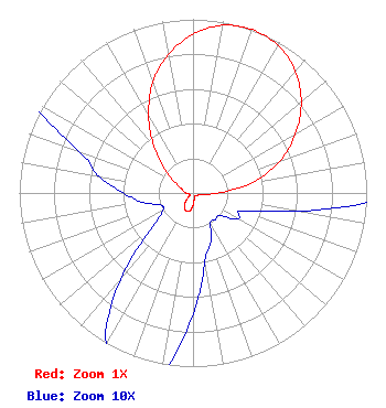 | ||||||||||||||||||
| Azimuth | Ratio | Azimuth | Ratio | Azimuth | Ratio | Azimuth | Ratio | ||||||||||||
| 0 | 0.915 | 10 | 0.980 | 20 | 1.000 | 30 | 0.980 | ||||||||||||
| 40 | 0.917 | 50 | 0.813 | 60 | 0.680 | 70 | 0.530 | ||||||||||||
| 80 | 0.350 | 90 | 0.140 | 100 | 0.060 | 110 | 0.030 | ||||||||||||
| 120 | 0.030 | 130 | 0.020 | 140 | 0.020 | 150 | 0.020 | ||||||||||||
| 160 | 0.030 | 170 | 0.040 | 180 | 0.070 | 190 | 0.105 | ||||||||||||
| 200 | 0.110 | 210 | 0.100 | 220 | 0.065 | 230 | 0.030 | ||||||||||||
| 240 | 0.020 | 250 | 0.020 | 260 | 0.030 | 270 | 0.040 | ||||||||||||
| 280 | 0.055 | 290 | 0.070 | 300 | 0.115 | 310 | 0.210 | ||||||||||||
| 320 | 0.350 | 330 | 0.510 | 340 | 0.680 | 350 | 0.810 | ||||||||||||
Structure Registration Number 1245109 Structure Type: TOWER Registered To: Scripps Broadcasting Holdings LLC Structure Address: South Of State Highway 78 Columbus, MT County Name: Stillwater County ASR Issued: 05/02/2019 Date Built: 09/20/2004 Site Elevation: 1104 m (3622 ft.) Structure Height: 9.1 m (30 ft.) Height Overall: 9.1 m (30 ft.) Overall Height AMSL: 1113.1 m (3652 ft.) FAA Determination: 09/02/2004 FAA Study #: 2004-ANM-1099-OE Paint & Light FAA Chapters: NONE Removed expiration date from determination. Scenario 1./jjs/case#635066 45-37-36.0 N 109-15-39.0 W (NAD 83) 45-37-36.2 N 109-15-36.4 W (Converted to NAD 27) |
W. 999 Riverside Avenue Spokane, WA 99210 Phone: 509-459-5220 Applicant | Date: 08/31/2009 Application Certifier MMM LICENSE II LLC 900 Laskin Road Virginia Beach, VA 23451 Applicant CLARENCE M BEVERAGE Communications Technologies, Inc. P.o. Box 1130 Marlton, NJ 08053 BROADCAST ENGINEERING CONSULTANT JULIAN L. SHEPARD, ESQ. Williams Mullen, A Professional Corporation | |||||||||||||||||