
FCCInfo.com
A Service of Cavell, Mertz & Associates, Inc.
(855) FCC-INFO
|
|
WNFT-LD from 01/12/2007 |
|
|
||||||||||||||||
|
|
Status: License Application Accepted: 07/14/2011 License Expires: 02/01/2021 File Number: BLDTL-20110714ACG Prefix Type: This is BLDTL FCC Website Links: LMS Facility Details This Application Other WNFT-LD Applications Including Superseded Applications Mailing Address Correspondence for WNFT-LD Correspondence related to application BLDTL-20110714ACG Service Contour - Open Street Map or USGS Map (51 dBu) Service Contour - KML / Google Earth (51 dBu) Rabbit Ears Info Search for WNFT-LD Site Location: 29-37-47.3 N 82-34-24.5 W (NAD 83) Site Location: 29-37-46.4 N 82-34-25.1 W (Converted to NAD 27) ERP: 15 kW Electrical Beam Tilt: 0.75 degrees R/C AGL: 289.8 m (951 ft.) R/C AMSL: 316 m (1037 ft.) Emission Mask: Stringent Site Elevation: 26.2 m. (86 ft.) Height Overall*: 293.5 m (963 ft.) (* As Filed In This Application, may differ from ASR Data, Below.) Directional Antenna - Antenna Make/Model: Systems With Reliability Inc. SWLP16MC/CP MODIFIED (FCC PAT # 18054) Antenna ID: 90209 | ||||||||||||||||||
| Antenna Data for Antenna Id: 90209 WNFT-LD LD File: BLDTL-20110714ACG Systems With Reliability Inc. - SWLP16MC/CP MODIFIED (FCC PAT # 18054) Service: LD Standard Pattern: Y Pattern and Field Values Include a 120° Clockwise Rotation | 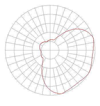 | ||||||||||||||||||
| Azimuth | Ratio | Azimuth | Ratio | Azimuth | Ratio | Azimuth | Ratio | ||||||||||||
| 0 | 0.225 | 10 | 0.240 | 20 | 0.240 | 30 | 0.330 | ||||||||||||
| 40 | 0.520 | 50 | 0.725 | 60 | 0.880 | 70 | 0.970 | ||||||||||||
| 75 | 1.000 | 80 | 0.980 | 90 | 0.960 | 100 | 0.950 | ||||||||||||
| 110 | 0.975 | 120 | 1.000 | 130 | 0.975 | 140 | 0.950 | ||||||||||||
| 150 | 0.960 | 160 | 0.980 | 165 | 1.000 | 170 | 0.970 | ||||||||||||
| 180 | 0.880 | 190 | 0.725 | 200 | 0.520 | 210 | 0.330 | ||||||||||||
| 220 | 0.240 | 230 | 0.240 | 240 | 0.225 | 250 | 0.215 | ||||||||||||
| 260 | 0.200 | 270 | 0.215 | 280 | 0.230 | 290 | 0.245 | ||||||||||||
| 300 | 0.250 | 310 | 0.245 | 320 | 0.230 | 330 | 0.215 | ||||||||||||
| 340 | 0.200 | 350 | 0.215 | ||||||||||||||||
Structure Registration Number 1029138 [ASR Heights Differ from WNFT-LD Application] Structure Type: GTOWER Registered To: NexTower Development Group, LLC Structure Address: 280 Ft West Of 21726 Sw 30th Ave Newberry, FL County Name: Alachua County ASR Issued: 02/14/2019 Date Built: 03/14/2014 Site Elevation: 26.5 m (87 ft.) Structure Height: 147.5 m (484 ft.) Height Overall: 147.5 m (484 ft.) Overall Height AMSL: 174 m (571 ft.) FAA Determination: 08/01/2012 FAA Study #: 2012-ASO-4344-OE Paint & Light FAA Chapters: NONE PRIOR STUDY 1994-ASO-492-OE 29-37-47.3 N 82-34-24.5 W (NAD 83) 29-37-46.4 N 82-34-25.1 W (Converted to NAD 27) |
4150 N. W. 93rd Ave Gainesville, FL 32653 Phone: 352-371-7772 Corporation | Date: 07/14/2011 Application Certifier BUDD BROADCASTING CO., INC. 4150 Nw 93rd Avenue Gainsville, FL 32653 Applicant ROBERT CARR 4818 Nw 17th Pl Gainesville, FL 32605 CONSULTING ENGINEER AARON P. SHAINIS Shainis & Peltzman, Chartered | |||||||||||||||||