
FCCInfo.com
A Service of Cavell, Mertz & Associates, Inc.
(855) FCC-INFO
|
|
K43JV from 09/24/1992 |
|
|
||||||||||||||||
|
|
Status: License (Licensed And Silent) Application Accepted: 10/30/2006 License Expires: 10/01/2022 File Number: BLTTL-20061030AQA Prefix Type: This is a license for a UHF LPTV station FCC Website Links: LMS Facility Details This Application Other K43JV Applications Including Superseded Applications Mailing Address Correspondence for K43JV Correspondence related to application BLTTL-20061030AQA Service Contour - Open Street Map or USGS Map (74 dBu) Service Contour - KML / Google Earth (74 dBu) Rabbit Ears Info Search for K43JV Site Location: 40-16-23.8 N 111-55-29.6 W (NAD 83) Site Location: 40-16-24.0 N 111-55-26.8 W (Converted to NAD 27) ERP: 4 kW R/C AGL: 15 m (49 ft.) R/C AMSL: 2314 m (7592 ft.) Site Elevation: 2299 m. (7543 ft.) Height Overall*: 21.9 m (72 ft.) (* As Filed In This Application, may differ from ASR Data, Below.) Directional Antenna - Antenna Make/Model: Jampro JA/LS-AW-8 Antenna ID: 19403 | ||||||||||||||||||
| Antenna Data for Antenna Id: 19403 K43JV TX File: BLTTL-20061030AQA Jampro - JA/LS-AW-8 Service: TX Standard Pattern: Y Pattern and Field Values Include a 100° Clockwise Rotation | 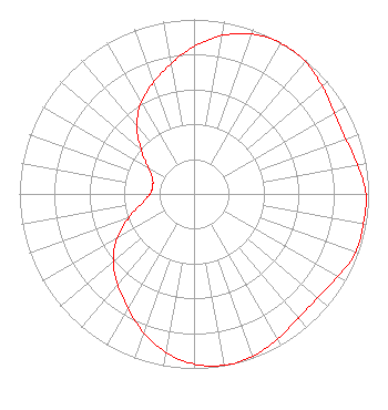 | ||||||||||||||||||
| Azimuth | Ratio | Azimuth | Ratio | Azimuth | Ratio | Azimuth | Ratio | ||||||||||||
| 0 | 0.845 | 10 | 0.922 | 20 | 0.975 | 30 | 0.997 | ||||||||||||
| 40 | 0.990 | 50 | 0.959 | 60 | 0.929 | 70 | 0.925 | ||||||||||||
| 80 | 0.951 | 90 | 0.985 | 100 | 0.985 | 110 | 0.985 | ||||||||||||
| 120 | 0.951 | 130 | 0.925 | 140 | 0.929 | 150 | 0.959 | ||||||||||||
| 160 | 0.990 | 170 | 0.997 | 180 | 0.975 | 190 | 0.922 | ||||||||||||
| 200 | 0.845 | 210 | 0.758 | 220 | 0.680 | 230 | 0.605 | ||||||||||||
| 240 | 0.510 | 250 | 0.397 | 260 | 0.302 | 270 | 0.253 | ||||||||||||
| 280 | 0.241 | 290 | 0.253 | 300 | 0.302 | 310 | 0.397 | ||||||||||||
| 320 | 0.510 | 330 | 0.605 | 340 | 0.680 | 350 | 0.758 | ||||||||||||
Structure Registration Number 1206227 Structure Type: TOWER Registered To: Line One Inc Structure Address: Lake Mountain Provo, UT County Name: Utah County ASR Issued: 11/17/1999 Date Built: 05/01/2000 Site Elevation: 2299 m (7543 ft.) Structure Height: 19 m (62 ft.) Height Overall: 21.9 m (72 ft.) Overall Height AMSL: 2320.9 m (7615 ft.) FAA Determination: 04/10/1998 FAA Study #: 97-ANM-1553-OE Paint & Light FAA Chapters: NONE 40-16-23.8 N 111-55-29.6 W (NAD 83) 40-16-24.0 N 111-55-26.8 W (Converted to NAD 27) |
Hurst, TX 76054 Phone: 214-770-7770 Corporation | Date: 10/30/2006 Application Certifier THREE ANGELS BROADCASTING NETWORK, INC. P O Box 220 West Frankfort, IL 62896-0220 Applicant DANIEL N. PEEK P O Box 220 West Frankfort, IL 62896-0220 ENGINEER MOSES PRIMO 3abn | |||||||||||||||||