
FCCInfo.com
A Service of Cavell, Mertz & Associates, Inc.
(855) FCC-INFO
|
|
|
Virtual Channel 33 |  |
|
|||||||||||||||
|
|
Repacking Information: No changes Status: License Application Accepted: 09/09/2013 License Expires: 02/01/2021 File Number: BLCDT-20130909AAU Prefix Type: This is a License for a commercial digital TV station FCC Website Links: LMS Facility Details This Application Other WBFS-TV Applications Including Superseded Applications Mailing Address Correspondence for WBFS-TV Correspondence related to application BLCDT-20130909AAU Service Contour - Open Street Map or USGS Map (41 dBu) Service Contour - KML / Google Earth (41 dBu) Public Inspection Files Rabbit Ears Info Search for WBFS-TV Site Location: 25-58-08.0 N 80-13-19.0 W (NAD 83) Site Location: 25-58-06.7 N 80-13-19.8 W (Converted to NAD 27) ERP: 1000 kW Polarization: Elliptically polarized HAAT: 296.9 m (974 ft.) Electrical Beam Tilt: 0.7 degrees R/C AGL: 296.6 m (973 ft.) R/C AMSL: 299 m (981 ft.) Site Elevation: 2.4 m. (8 ft.) Height Overall*: 317.3 m (1041 ft.) (* As Filed In This Application, may differ from ASR Data, Below.) Directional Antenna - Antenna Make/Model: DIELECTRIC TUM20-3BP-12/30U-1 Antenna ID: 111579 Polarization: Elliptically polarized | ||||||||||||||||||
| Antenna Data for Antenna Id: 111579 WBFS-TV DT File: BLCDT-20130909AAU DIELECTRIC - TUM20-3BP-12/30U-1 Service: DT Standard Pattern: Y | 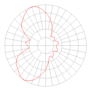 | ||||||||||||||||||
| Azimuth | Ratio | Azimuth | Ratio | Azimuth | Ratio | Azimuth | Ratio | ||||||||||||
| 0 | 0.803 | 10 | 0.653 | 20 | 0.473 | 30 | 0.271 | ||||||||||||
| 40 | 0.269 | 50 | 0.296 | 60 | 0.235 | 70 | 0.292 | ||||||||||||
| 80 | 0.325 | 90 | 0.272 | 100 | 0.269 | 110 | 0.317 | ||||||||||||
| 120 | 0.304 | 130 | 0.231 | 140 | 0.299 | 150 | 0.333 | ||||||||||||
| 160 | 0.291 | 170 | 0.411 | 180 | 0.595 | 190 | 0.753 | ||||||||||||
| 200 | 0.901 | 210 | 0.986 | 213 | 0.990 | 220 | 0.963 | ||||||||||||
| 230 | 0.886 | 240 | 0.826 | 250 | 0.687 | 260 | 0.426 | ||||||||||||
| 270 | 0.433 | 277 | 0.493 | 280 | 0.482 | 290 | 0.403 | ||||||||||||
| 300 | 0.591 | 310 | 0.769 | 320 | 0.850 | 330 | 0.946 | ||||||||||||
| 340 | 1.000 | 350 | 0.941 | ||||||||||||||||
Structure Registration Number 1026553 [ASR Heights Differ from WBFS-TV Application] Structure Type: GTOWER Registered To: American Towers LLC Structure Address: 1255 Nw 210th Street (282698) Miami, FL County Name: Miami-Dade County ASR Issued: 10/12/2023 Date Built: 01/01/1990 Site Elevation: 1.5 m (5 ft.) Structure Height: 289.9 m (951 ft.) Height Overall: 318.2 m (1044 ft.) Overall Height AMSL: 319.7 m (1049 ft.) FAA Determination: 04/21/2023 FAA Study #: 2022-ASO-14780-OE FAA Circular #: 70/7460-1G Paint & Light FAA Chapters: 4, 6, 9 OM&L to remain the same as prior study = 24-HR HI-STROBES 25-58-08.3 N 80-13-19.2 W (NAD 83) 25-58-07.0 N 80-13-20.0 W (Converted to NAD 27) |
2020 M St., Nw - Licensing Dept Washington, DC 20036 Phone: 202-457-4505 Corporation | Date: 09/09/2013 Application Certifier MIAMI TELEVISION STATION WBFS INC. Suite 920 1800 K St Street Nw Washington, DC 20006 Applicant EDWIN L. NASS 1800 K Street Nw, Suite 920 Washington, DC 20006 DIRECTOR OF SPECTRUM MANAGEMENT E. L. NASS Cbs Suite 920 1800 K Street Nw Washington, DC 20006 | |||||||||||||||||
|
| ||||||||||||||||||