
FCCInfo.com
A Service of Cavell, Mertz & Associates, Inc.
(855) FCC-INFO
|
|
|
|
|
||||||||||||||||
|
|
Status: License Application Accepted: 06/20/2012 License Expires: 12/01/2021 File Number: BLDTL-20120620ABV Prefix Type: This is BLDTL FCC Website Links: LMS Facility Details This Application Other W26EE-D Applications Including Superseded Applications Mailing Address Correspondence for W26EE-D Correspondence related to application BLDTL-20120620ABV Service Contour - Open Street Map or USGS Map (51 dBu) Service Contour - KML / Google Earth (51 dBu) Rabbit Ears Info Search for W26EE-D Site Location: 44-57-53.9 N 89-00-18.4 W (NAD 83) Site Location: 44-57-54.0 N 89-00-18.0 W (Converted to NAD 27) ERP: 15 kW Electrical Beam Tilt: -1.75 degrees R/C AGL: 152 m (499 ft.) R/C AMSL: 530 m (1739 ft.) Emission Mask: Stringent Site Elevation: 378 m. (1240 ft.) Height Overall*: 152 m (499 ft.) (* As Filed In This Application, may differ from ASR Data, Below.) Directional Antenna - Antenna Make/Model: Scala SL-8 Antenna ID: 23503 | ||||||||||||||||||
| Antenna Data for Antenna Id: 23503 W26EE-D LD File: BLDTL-20120620ABV Scala - SL-8 Service: LD Standard Pattern: Y Pattern and Field Values Include a 270° Clockwise Rotation | 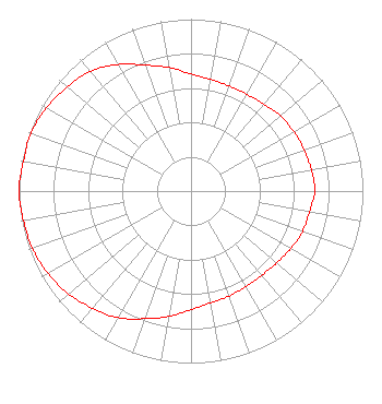 | ||||||||||||||||||
| Azimuth | Ratio | Azimuth | Ratio | Azimuth | Ratio | Azimuth | Ratio | ||||||||||||
| 0 | 0.680 | 10 | 0.660 | 20 | 0.650 | 30 | 0.650 | ||||||||||||
| 40 | 0.660 | 50 | 0.680 | 60 | 0.690 | 70 | 0.700 | ||||||||||||
| 80 | 0.710 | 90 | 0.720 | 100 | 0.700 | 110 | 0.690 | ||||||||||||
| 120 | 0.670 | 130 | 0.650 | 140 | 0.640 | 150 | 0.640 | ||||||||||||
| 160 | 0.650 | 170 | 0.660 | 180 | 0.690 | 190 | 0.740 | ||||||||||||
| 200 | 0.790 | 210 | 0.850 | 220 | 0.890 | 230 | 0.930 | ||||||||||||
| 240 | 0.960 | 250 | 0.980 | 260 | 0.990 | 270 | 1.000 | ||||||||||||
| 280 | 0.990 | 290 | 0.990 | 300 | 0.970 | 310 | 0.940 | ||||||||||||
| 320 | 0.910 | 330 | 0.850 | 340 | 0.780 | 350 | 0.730 | ||||||||||||
Structure Registration Number 1247723 Structure Type: TOWER Registered To: VCY America, Inc. Structure Address: Site Is West Of Spruce Rd. Between Gold Creek Rd. And Willow Rd. Mattoon, WI County Name: Shawano County ASR Issued: 03/28/2005 Date Built: 08/19/2007 Site Elevation: 378 m (1240 ft.) Structure Height: 152.4 m (500 ft.) Height Overall: 152.4 m (500 ft.) Overall Height AMSL: 530.4 m (1740 ft.) FAA Determination: 03/25/2005 FAA Study #: 2005-AGL-1183-OE FAA Circular #: 70/7460-1K Paint & Light FAA Chapters: 3, 4, 5, 12 Removed expiration date from determination. Scenario 1./jjs/case#635066 44-57-53.9 N 89-00-18.4 W (NAD 83) 44-57-54.0 N 89-00-18.0 W (Converted to NAD 27) |
3434 W. Kilbourn Ave Milwaukee, WI 53208 Phone: 414-935-3000 Corporation | Date: 06/20/2012 Application Certifier VCY AMERICA, INC. 3434 W. Kilbourn Ave Milwaukee, WI 53208-3313 Applicant DANNY LANGSTON Sterling Communications, Inc. 219 Dodd Rd. Ringgold, GA 30736-2958 TECHNICAL CONSULTANT DANNY LANGSTON Sterling Communications, Inc. | |||||||||||||||||