
FCCInfo.com
A Service of Cavell, Mertz & Associates, Inc.
(855) FCC-INFO
|
|
WFTY-DT from 01/01/2004 WFTY-DT from 11/01/2001 WFTY-DT from 12/29/1992 WFTY-DT from 01/23/1987 WFTY-DT from 01/10/1979 |
Virtual Channel 67 |
|
|||||||||||||||||||
|
|
Repacking Information: No changes Status: License Application Accepted: 04/27/2012 License Expires: 06/01/2023 File Number: BLCDT-20120427ABO Prefix Type: This is a License for a commercial digital TV station FCC Website Links: LMS Facility Details This Application Other WFTY-DT Applications Including Superseded Applications Mailing Address Correspondence for WFTY-DT Correspondence related to application BLCDT-20120427ABO Service Contour - Open Street Map or USGS Map (41 dBu) Service Contour - KML / Google Earth (41 dBu) Public Inspection Files Rabbit Ears Info Search for WFTY-DT Site Location: 40-53-23.0 N 72-57-11.0 W (NAD 83) Site Location: 40-53-22.6 N 72-57-12.6 W (Converted to NAD 27) ERP: 655 kW Polarization: Elliptically polarized HAAT: 219 m (719 ft.) Electrical Beam Tilt: 0.75 degrees R/C AGL: 200 m (656 ft.) R/C AMSL: 243 m (797 ft.) Site Elevation: 43 m. (141 ft.) Height Overall*: 207.6 m (681 ft.) (* As Filed In This Application, may differ from ASR Data, Below.) Directional Antenna - Antenna Make/Model: Electronics Research Inc. ATW16H3-HTS180-23H Antenna ID: 107216 Polarization: Elliptically polarized | |||||||||||||||||||||
| Antenna Data for Antenna Id: 107216 WFTY-DT DT File: BLCDT-20120427ABO Electronics Research Inc. - ATW16H3-HTS180-23H Service: DT Standard Pattern: Y | 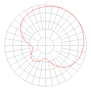 | |||||||||||||||||||||
| Azimuth | Ratio | Azimuth | Ratio | Azimuth | Ratio | Azimuth | Ratio | |||||||||||||||
| 0 | 0.949 | 10 | 0.968 | 20 | 0.985 | 30 | 0.996 | |||||||||||||||
| 40 | 1.000 | 50 | 0.996 | 60 | 0.985 | 70 | 0.968 | |||||||||||||||
| 80 | 0.949 | 90 | 0.928 | 100 | 0.906 | 110 | 0.878 | |||||||||||||||
| 120 | 0.839 | 130 | 0.780 | 140 | 0.697 | 150 | 0.591 | |||||||||||||||
| 160 | 0.474 | 170 | 0.369 | 180 | 0.319 | 190 | 0.343 | |||||||||||||||
| 200 | 0.403 | 210 | 0.455 | 220 | 0.475 | 230 | 0.455 | |||||||||||||||
| 240 | 0.403 | 250 | 0.343 | 260 | 0.319 | 270 | 0.369 | |||||||||||||||
| 280 | 0.474 | 290 | 0.591 | 300 | 0.697 | 310 | 0.780 | |||||||||||||||
| 320 | 0.839 | 330 | 0.878 | 340 | 0.906 | 350 | 0.928 | |||||||||||||||
Structure Registration Number 1007666 Structure Type: TOWER Registered To: Univision Television Group, Inc. Structure Address: 607 Middle Country Rd Middle Island, NY County Name: Suffolk County ASR Issued: 10/18/2007 Date Built: 10/04/1984 Site Elevation: 43 m (141 ft.) Structure Height: 195.2 m (640 ft.) Height Overall: 207.6 m (681 ft.) Overall Height AMSL: 250.6 m (822 ft.) FAA Determination: 09/08/2006 FAA Study #: 2006-AEA-3199-OE FAA Circular #: 70/7460-1K Paint & Light FAA Chapters: 4, 7, 12 PRIOR STUDY 1996-AEA-2255-OE 40-53-23.0 N 72-57-11.0 W (NAD 83) 40-53-22.6 N 72-57-12.6 W (Converted to NAD 27) |
101 Constitution Avenue, Nw, Suite 800w Washington, DC 20001 Phone: 310-348-3600 Limited Liability Company | Date: 04/27/2012 Application Certifier UNIVISION NEW YORK LLC 5999 Center Drive Los Angeles, CA 90045 Applicant KARL D. LAHM, P.E. Univision Management Co. P.o. Box 647 Lake Villa, IL 60046 DIRECTOR, RF SYSTEMS ENGINEERING WILLIAM H. FITZ Covington & Burling Llp 1201 Pennsylvania Avenue, Nw Washington, DC 20004 | ||||||||||||||||||||
| ||||||||||||||||||||||