
FCCInfo.com
A Service of Cavell, Mertz & Associates, Inc.
(855) FCC-INFO
|
|
WBFL-CD from 09/15/2015 WBFL-CD from 05/08/2003 WBFL-CD from 06/23/2000 WBFL-CD from 03/03/1993 WBFL-CD from 01/30/1990 |
|
|
||||||||||||||||
|
|
Repacking Information: No changes Status: License Application Accepted: 09/11/2015 License Expires: 04/01/2021 File Number: -0000004604 FCC Website Links: LMS Facility Details This Application Other WBFL-CD Applications Including Superseded Applications Mailing Address Correspondence for WBFL-CD Correspondence related to application -0000004604 Service Contour - Open Street Map or USGS Map (48 dBu) Service Contour - KML / Google Earth (48 dBu) Public Inspection Files Rabbit Ears Info Search for WBFL-CD Site Location: 30-40-09.0 N 83-19-31.0 W (NAD 83) Site Location: 30-40-08.3 N 83-19-31.5 W (Converted to NAD 27) ERP: 2 kW Polarization: Horizontally polarized R/C AGL: 115 m (377 ft.) R/C AMSL: 152.0 m (499 ft.) Emission Mask: Full Service Site Elevation: 37 m. (121 ft.) Height Overall*: 152 m (499 ft.) (* As Filed In This Application, may differ from ASR Data, Below.) Directional Antenna - Antenna Make/Model: Scala HDCA-10H Antenna ID: 89573 Polarization: Horizontally polarized | ||||||||||||||||||
| Antenna Data for Antenna Id: 89573 WBFL-CD DC File: -0000004604 Scala - HDCA-10H Service: DC Standard Pattern: Y Pattern and Field Values Include a 5° Clockwise Rotation | 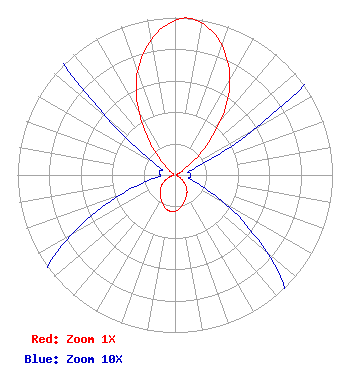 | ||||||||||||||||||
| Azimuth | Ratio | Azimuth | Ratio | Azimuth | Ratio | Azimuth | Ratio | ||||||||||||
| 5 | 1.000 | 15 | 0.937 | 25 | 0.792 | 35 | 0.585 | ||||||||||||
| 45 | 0.320 | 55 | 0.108 | 65 | 0.030 | 75 | 0.010 | ||||||||||||
| 85 | 0.010 | 95 | 0.010 | 105 | 0.010 | 115 | 0.023 | ||||||||||||
| 125 | 0.055 | 135 | 0.097 | 145 | 0.133 | 155 | 0.162 | ||||||||||||
| 165 | 0.192 | 175 | 0.222 | 185 | 0.233 | 195 | 0.222 | ||||||||||||
| 205 | 0.192 | 215 | 0.162 | 225 | 0.133 | 235 | 0.097 | ||||||||||||
| 245 | 0.055 | 255 | 0.023 | 265 | 0.010 | 275 | 0.010 | ||||||||||||
| 285 | 0.010 | 295 | 0.010 | 305 | 0.030 | 315 | 0.108 | ||||||||||||
| 325 | 0.320 | 335 | 0.585 | 345 | 0.792 | 355 | 0.937 | ||||||||||||
Structure Registration Number 1019858 Structure Type: TOWER Registered To: Lowndes County Board of Commissioners Structure Address: 1.5 Mi South Clyatteville, GA County Name: Lowndes County ASR Issued: 05/21/2013 Date Built: 01/01/1995 Site Elevation: 37 m (121 ft.) Structure Height: 152 m (499 ft.) Height Overall: 152 m (499 ft.) Overall Height AMSL: 189 m (620 ft.) FAA Determination: 06/23/1994 FAA Study #: 94-ASO-0051-OE FAA Circular #: 70/7460-1H Paint & Light FAA Chapters: 3, 4, 5, 13 30-40-09.0 N 83-19-31.0 W (NAD 83) 30-40-08.3 N 83-19-31.5 W (Converted to NAD 27) |
1181 Highway 315 Wilkes-barre, PA 18702 Phone: 570-970-5600 Limited Liability Company | Title: Ceo Date: 09/11/2015 Application Certifier NEW AGE MEDIA OF TALLAHASSEE LICENSE, LLC New Age Media Of Tallahassee License, Llc 1181 Highway 315 Wilkes-barre, PA 18702 Applicant Frank R. Jazzo, Esq. Fletcher, Heald & Hildreth, P.l.c. 1300 North 17th Street 11th Floor Arlington, VA 22209 | |||||||||||||||||