
FCCInfo.com
A Service of Cavell, Mertz & Associates, Inc.
(855) FCC-INFO
|
|
WZZM from 07/27/1979 |
Virtual Channel 13 |  |
|
||||||||||||||||||||||||||||||||||||
|
|
Repacking Information: No changes Status: License Application Accepted: 12/29/2015 License Expires: 10/01/2021 File Number: -0000007442 FCC Website Links: LMS Facility Details This Application Other WZZM Applications Including Superseded Applications Mailing Address Correspondence for WZZM Correspondence related to application -0000007442 Service Contour - Open Street Map or USGS Map (36 dBu) Service Contour - KML / Google Earth (36 dBu) Public Inspection Files Rabbit Ears Info Search for WZZM Site Location: 43-18-35.4 N 85-54-44.8 W (NAD 83) Site Location: 43-18-35.3 N 85-54-44.6 W (Converted to NAD 27) ERP: 12.3 kW Polarization: Horizontally polarized HAAT: 225.8 m (741 ft.) Electrical Beam Tilt: 0.5 degrees R/C AGL: 213.4 m (700 ft.) R/C AMSL: 453.3 m (1487 ft.) Site Elevation: 239.9 m. (787 ft.) Height Overall*: 323.1 m (1060 ft.) (* As Filed In This Application, may differ from ASR Data, Below.) Directional Antenna - Antenna Make/Model: DIELECTRIC THB-C2-2H/4UD-1-S Antenna ID: 110391 Polarization: Horizontally polarized | |||||||||||||||||||||||||||||||||||||||
| Antenna Data for Antenna Id: 110391 WZZM DX File: -0000007442 DIELECTRIC - THB-C2-2H/4UD-1-S Service: DX Standard Pattern: Y | 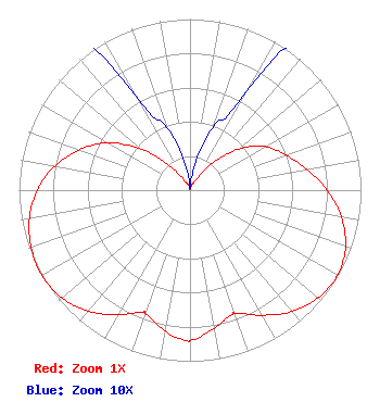 | |||||||||||||||||||||||||||||||||||||||
| Azimuth | Ratio | Azimuth | Ratio | Azimuth | Ratio | Azimuth | Ratio | |||||||||||||||||||||||||||||||||
| 0 | 0.001 | 10 | 0.013 | 20 | 0.039 | 30 | 0.066 | |||||||||||||||||||||||||||||||||
| 40 | 0.204 | 50 | 0.374 | 60 | 0.509 | 70 | 0.597 | |||||||||||||||||||||||||||||||||
| 80 | 0.695 | 90 | 0.802 | 100 | 0.898 | 110 | 0.968 | |||||||||||||||||||||||||||||||||
| 120 | 0.996 | 130 | 0.978 | 140 | 0.927 | 150 | 0.844 | |||||||||||||||||||||||||||||||||
| 160 | 0.767 | 161 | 0.766 | 170 | 0.819 | 180 | 0.879 | |||||||||||||||||||||||||||||||||
| 181 | 0.880 | 190 | 0.837 | 200 | 0.766 | 201 | 0.765 | |||||||||||||||||||||||||||||||||
| 210 | 0.842 | 220 | 0.924 | 230 | 0.978 | 240 | 1.000 | |||||||||||||||||||||||||||||||||
| 250 | 0.988 | 260 | 0.954 | 270 | 0.894 | 280 | 0.804 | |||||||||||||||||||||||||||||||||
| 290 | 0.688 | 300 | 0.553 | 310 | 0.369 | 320 | 0.188 | |||||||||||||||||||||||||||||||||
| 330 | 0.064 | 340 | 0.039 | 350 | 0.015 | |||||||||||||||||||||||||||||||||||
Structure Registration Number 1234009 Structure Type: TOWER Registered To: Combined Communications of Oklahoma, LLC Structure Address: Grand Rapids Grand Rapids, MI County Name: Newaygo County ASR Issued: 02/08/2019 Date Built: 12/19/2002 Site Elevation: 239.9 m (787 ft.) Structure Height: 323.1 m (1060 ft.) Height Overall: 323.1 m (1060 ft.) Overall Height AMSL: 563 m (1847 ft.) FAA Determination: 12/03/2002 FAA Study #: 2002-AGL-6019-OE FAA Circular #: 70/7460-1K Paint & Light FAA Chapters: 4, 7, 12 PRIOR STUDY 2002-AGL-1099-OE 43-18-35.4 N 85-54-44.8 W (NAD 83) 43-18-35.3 N 85-54-44.6 W (Converted to NAD 27) |
Tegna Inc. 8350 Broad Street, Suite 2000 Tysons, VA 22102 Phone: 703-873-6606 Limited Liability Company | Title: Secretary Date: 12/29/2015 Application Certifier Combined Communications Of Oklahoma, Llc C/o Gannett Co., Inc. 7950 Jones Branch Drive Mclean, VA 22107 Applicant LINDA Carducci Tegna Inc. 7950 Jones Branch Drive Tegna Inc. Mclean, VA 22107 | ||||||||||||||||||||||||||||||||||||||
|
| |||||||||||||||||||||||||||||||||||||||