
FCCInfo.com
A Service of Cavell, Mertz & Associates, Inc.
(855) FCC-INFO
|
|
K32LQ-D from 07/19/2004 |
|
|
||||||||||||||||
|
|
Status: License Application Accepted: 11/09/2016 License Expires: 12/01/2022 File Number: -0000017048 FCC Website Links: LMS Facility Details This Application Other K32LQ-D Applications Including Superseded Applications Mailing Address Correspondence for K32LQ-D Correspondence related to application -0000017048 Service Contour - Open Street Map or USGS Map (51 dBu) Service Contour - KML / Google Earth (51 dBu) Rabbit Ears Info Search for K32LQ-D Site Location: 41-43-30.4 N 122-37-35.7 W (NAD 83) Site Location: 41-43-30.9 N 122-37-31.6 W (Converted to NAD 27) ERP: 2.32 kW Polarization: Horizontally polarized Electrical Beam Tilt: 1.5 degrees R/C AGL: 18 m (59 ft.) R/C AMSL: 997.6 m (3273 ft.) Emission Mask: Stringent Site Elevation: 979.6 m. (3214 ft.) Height Overall*: 20.7 m (68 ft.) (* As Filed In This Application, may differ from ASR Data, Below.) Directional Antenna - Antenna Make/Model: DIELECTRIC DLP-8-B Antenna ID: 1000883 Polarization: Horizontally polarized
| ||||||||||||||||||
| Antenna Data for Antenna Id: 1000883 K32LQ-D LD File: -0000017048 DIELECTRIC - DLP-8-B Service: LD Standard Pattern: N Pattern and Field Values Include a 120° Clockwise Rotation | 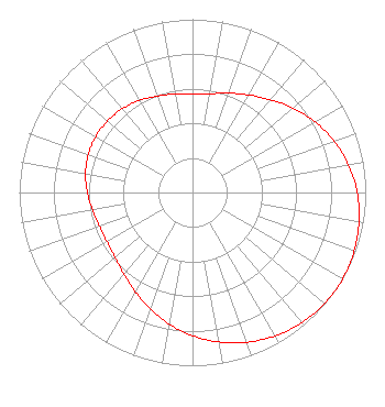 | ||||||||||||||||||
| Azimuth | Ratio | Azimuth | Ratio | Azimuth | Ratio | Azimuth | Ratio | ||||||||||||
| 0 | 0.570 | 10 | 0.579 | 20 | 0.610 | 30 | 0.650 | ||||||||||||
| 40 | 0.699 | 50 | 0.759 | 60 | 0.817 | 70 | 0.869 | ||||||||||||
| 80 | 0.914 | 90 | 0.951 | 100 | 0.975 | 110 | 0.993 | ||||||||||||
| 120 | 1.000 | 130 | 0.996 | 140 | 0.981 | 150 | 0.955 | ||||||||||||
| 160 | 0.920 | 170 | 0.876 | 180 | 0.826 | 190 | 0.771 | ||||||||||||
| 200 | 0.714 | 210 | 0.661 | 220 | 0.615 | 230 | 0.583 | ||||||||||||
| 240 | 0.569 | 250 | 0.571 | 260 | 0.586 | 270 | 0.607 | ||||||||||||
| 280 | 0.627 | 290 | 0.640 | 300 | 0.645 | 310 | 0.641 | ||||||||||||
| 320 | 0.631 | 330 | 0.613 | 340 | 0.592 | 350 | 0.579 | ||||||||||||
Structure Registration Number 1201550 Structure Type: TOWER Registered To: CALIFORNIA OREGON BROADCASTING, INC. Structure Address: Butcher Hill Yreka, CA County Name: Siskiyou County ASR Issued: 08/18/1999 Date Built: 08/20/1999 Site Elevation: 979.6 m (3214 ft.) Structure Height: 15.2 m (50 ft.) Height Overall: 20.7 m (68 ft.) Overall Height AMSL: 1000.3 m (3282 ft.) FAA Determination: 11/01/1993 FAA Study #: 93-AWP-1171-OE Paint & Light FAA Chapters: NONE 41-43-30.4 N 122-37-35.7 W (NAD 83) 41-43-30.9 N 122-37-31.6 W (Converted to NAD 27) |
3000 Worldreach Drive Indian Land, SC 29707 Phone: 803-578-1418 Limited Liability Company | Title: Cto Date: 11/09/2016 Application Certifier BROADCASTING LICENSES, L.P. Broadcasting Licenses, L.p. 2111 University Park Dr Ste 650 Okemos, MI 48864 Applicant Ron Sweatte Broadcasting Licenses, L.p. 4600 S Regal St Spokane, WA 99223 CTO DENNIS P. CORBETT Lerman Senter Pllc 2001 L Street, Nw Suite 400 Washington, DC 20036 COUNSEL Joseph M. Davis, P.E. Chesapeake Rf Consultants, Llc 207 Old Dominion Road Yorktown, VA 23692 Consulting Engineer | |||||||||||||||||