
FCCInfo.com
A Service of Cavell, Mertz & Associates, Inc.
(855) FCC-INFO
|
|
WOCW-LD from 05/26/2006 WOCW-LD from 12/04/2002 WOCW-LD from 10/08/1998 WOCW-LD from 07/01/1997 WOCW-LD from 11/21/1994 |
|
|
||||||||||||||||
|
|
Status: STA – Special Temporary Authority Application Accepted: 12/20/2016 STA Expires: 01/01/2017 File Number: -0000019219 FCC Website Links: LMS Facility Details This Application Other WOCW-LD Applications Including Superseded Applications Mailing Address Correspondence for WOCW-LD Correspondence related to application -0000019219 Service Contour - Open Street Map or USGS Map (74 dBu) Service Contour - KML / Google Earth (74 dBu) Rabbit Ears Info Search for WOCW-LD Site Location: 38-22-34.6 N 81-39-23.5 W (NAD 83) Site Location: 38-22-34.3 N 81-39-24.1 W (Converted to NAD 27) ERP: 25 kW R/C AGL: 76 m (249 ft.) R/C AMSL: 368.6 m (1209 ft.) Site Elevation: 292.6 m. (960 ft.) Height Overall*: 100.6 m (330 ft.) (* As Filed In This Application, may differ from ASR Data, Below.) Directional Antenna - Antenna Make/Model: Jampro JA/LS-DC-16 Antenna ID: 19473 | ||||||||||||||||||
| Antenna Data for Antenna Id: 19473 WOCW-LD TX File: -0000019219 Jampro - JA/LS-DC-16 Service: TX Standard Pattern: Y Pattern and Field Values Include a 270° Clockwise Rotation | 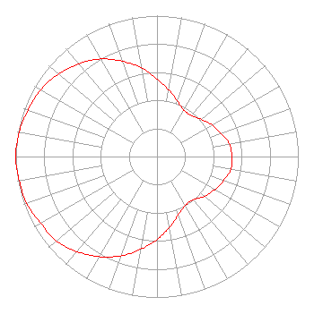 | ||||||||||||||||||
| Azimuth | Ratio | Azimuth | Ratio | Azimuth | Ratio | Azimuth | Ratio | ||||||||||||
| 0 | 0.550 | 10 | 0.480 | 20 | 0.420 | 30 | 0.380 | ||||||||||||
| 40 | 0.380 | 50 | 0.410 | 60 | 0.450 | 70 | 0.480 | ||||||||||||
| 80 | 0.520 | 90 | 0.530 | 100 | 0.530 | 110 | 0.500 | ||||||||||||
| 120 | 0.470 | 130 | 0.440 | 140 | 0.400 | 150 | 0.400 | ||||||||||||
| 160 | 0.440 | 170 | 0.510 | 180 | 0.590 | 190 | 0.670 | ||||||||||||
| 200 | 0.750 | 210 | 0.820 | 220 | 0.880 | 230 | 0.930 | ||||||||||||
| 240 | 0.950 | 250 | 0.980 | 260 | 0.990 | 270 | 1.000 | ||||||||||||
| 280 | 0.990 | 290 | 0.970 | 300 | 0.950 | 310 | 0.910 | ||||||||||||
| 320 | 0.860 | 330 | 0.800 | 340 | 0.720 | 350 | 0.640 | ||||||||||||
Structure Registration Number 1238159 Structure Type: TOWER Registered To: West Virginia Educational Broadcasting Authority Structure Address: 0.3 Mi. Se Of Intersection Of Hwy 622 And Chandlers Drive Charleston, WV County Name: Kanawha County ASR Issued: 03/24/2003 Date Built: 03/15/2004 Site Elevation: 292.6 m (960 ft.) Structure Height: 100.6 m (330 ft.) Height Overall: 100.6 m (330 ft.) Overall Height AMSL: 393.2 m (1290 ft.) FAA Determination: 11/27/2002 FAA Study #: 2002-AEA-1923-OE FAA Circular #: 70/7460-1K Paint & Light FAA Chapters: 3, 4, 5, 12 PRIOR STUDY 1999-AEA-1738-OE 38-22-34.6 N 81-39-23.5 W (NAD 83) 38-22-34.3 N 81-39-24.1 W (Converted to NAD 27) |
295 Madison Avenue, 12th Floor New York, NY 10017 Phone: 954-606-5486 Corporation | Title: President Date: 12/20/2016 Application Certifier DTV AMERICA CORPORATION Dtv America Corporation 13450 W Sunrise Blvd Ste 164 Sunrise, FL 33323 Applicant RENEE ILHARDT Dtv America Corporation 13450 W Sunrise Blvd Ste 164 Sunrise, FL 33323 | |||||||||||||||||