
FCCInfo.com
A Service of Cavell, Mertz & Associates, Inc.
(855) FCC-INFO
|
|
DWLPH-CD from 02/27/2014 DWLPH-CD from 03/24/2011 DWLPH-CD from 07/08/2009 DWLPH-CD from 07/20/2007 DWLPH-CD from 02/01/1996 DWLPH-CD from 11/24/1989 DWLPH-CD from 09/21/1987 |
RF spectrum relinquished in the spectrum auction |  |
|
|||||||||||||||
|
|
Repacking Information: Channel 44 was relinquished in the spectrum auction Status: License Application Accepted: 08/08/2017 License Expires: 02/01/2021 File Number: -0000029193 FCC Website Links: LMS Facility Details This Application Other DWLPH-CD Applications Including Superseded Applications Mailing Address Correspondence for DWLPH-CD Correspondence related to application -0000029193 Service Contour - Open Street Map or USGS Map (51 dBu) Service Contour - KML / Google Earth (51 dBu) Public Inspection Files Rabbit Ears Info Search for DWLPH-CD Site Location: 25-58-16.0 N 80-12-31.0 W (NAD 83) Site Location: 25-58-14.7 N 80-12-31.8 W (Converted to NAD 27) ERP: 15 kW Polarization: Horizontally polarized R/C AGL: 274.3 m (900 ft.) R/C AMSL: 275.8 m (905 ft.) Emission Mask: Simple Site Elevation: 1.5 m. (5 ft.) Height Overall*: 318.2 m (1044 ft.) (* As Filed In This Application, may differ from ASR Data, Below.) Directional Antenna - Antenna Make/Model: DIELECTRIC TUA-M-C3 SPECIAL Antenna ID: 1000824 Polarization: Horizontally polarized | ||||||||||||||||||
| Antenna Data for Antenna Id: 1000824 DWLPH-CD DC File: -0000029193 DIELECTRIC - TUA-M-C3 SPECIAL Service: DC Standard Pattern: N | 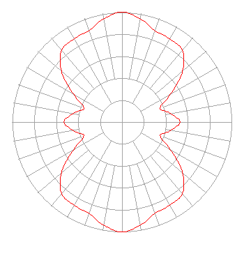 | ||||||||||||||||||
| Azimuth | Ratio | Azimuth | Ratio | Azimuth | Ratio | Azimuth | Ratio | ||||||||||||
| 0 | 1.000 | 10 | 0.954 | 20 | 0.884 | 30 | 0.875 | ||||||||||||
| 40 | 0.853 | 50 | 0.721 | 60 | 0.511 | 70 | 0.370 | ||||||||||||
| 80 | 0.447 | 90 | 0.527 | 100 | 0.447 | 110 | 0.370 | ||||||||||||
| 120 | 0.511 | 130 | 0.721 | 140 | 0.853 | 150 | 0.875 | ||||||||||||
| 160 | 0.884 | 170 | 0.954 | 180 | 1.000 | 190 | 0.954 | ||||||||||||
| 200 | 0.884 | 210 | 0.875 | 220 | 0.853 | 230 | 0.721 | ||||||||||||
| 240 | 0.511 | 250 | 0.370 | 260 | 0.447 | 270 | 0.527 | ||||||||||||
| 280 | 0.447 | 290 | 0.370 | 300 | 0.511 | 310 | 0.721 | ||||||||||||
| 320 | 0.853 | 330 | 0.875 | 340 | 0.884 | 350 | 0.954 | ||||||||||||
Structure Registration Number 1027529 Structure Type: TOWER Registered To: INDUSTRIAL COMMUNICATIONS & ELECTRONICS, INC. Structure Address: 350 Nw 215th Street North Miami, FL County Name: Miami-Dade County ASR Issued: 07/20/2000 Date Built: 07/03/1991 Site Elevation: 1.5 m (5 ft.) Structure Height: 303.5 m (996 ft.) Height Overall: 318.2 m (1044 ft.) Overall Height AMSL: 319.7 m (1049 ft.) FAA Determination: 11/26/1990 FAA Study #: 89-ASO-1111-OE FAA Circular #: 70/7460-1G Paint & Light FAA Chapters: 4, 6, 9 OM&L = 24-HR HI STROBES 25-58-16.0 N 80-12-31.0 W (NAD 83) 25-58-14.7 N 80-12-31.8 W (Converted to NAD 27) |
6200 Stoneridge Mall Road Suite 300 Pleasanton, CA 94588 Phone: 415-307-3528 Limited Liability Company | Title: General Manager - Station Operations Date: 08/08/2017 Application Certifier LOCUSPOINT WLPH LICENSEE, LLC Locuspoint Wlph Licensee, Llc 6200 Stoneridge Mall Road Suite 300 Pleasanton, CA 94588 Applicant Jonathan Cohen Wilkinson, Barker, Knauer, Llp 1800 M Street, Nw Suite 800n Washington, DC 20036 Partner Ian Milne Locuspoint Networks Llc 6200 Stoneridge Mall Road Suite 300 Pleasanton, CA 94588 General Manager - Station Operations | |||||||||||||||||