
FCCInfo.com
A Service of Cavell, Mertz & Associates, Inc.
(855) FCC-INFO
|
|
DW44CV-D from 02/25/2010 |
|
|
||||||||||||||||
|
|
Status: License Application Accepted: 12/07/2017 License Expires: 02/01/2021 File Number: -0000036137 FCC Website Links: LMS Facility Details This Application Other DW44CV-D Applications Including Superseded Applications Mailing Address Correspondence for DW44CV-D Correspondence related to application -0000036137 Service Contour - Open Street Map or USGS Map (51 dBu) Service Contour - KML / Google Earth (51 dBu) Rabbit Ears Info Search for DW44CV-D Site Location: 18-17-22.1 N 66-39-37.3 W (NAD 83) Site Location: 18-17-29.3 N 66-39-38.7 W (Converted to NAD 27) ERP: 15 kW Polarization: Horizontally polarized Electrical Beam Tilt: 0.5 degrees R/C AGL: 40 m (131 ft.) R/C AMSL: 659 m (2162 ft.) Emission Mask: Full Service Site Elevation: 619 m. (2031 ft.) Height Overall*: 69.8 m (229 ft.) (* As Filed In This Application, may differ from ASR Data, Below.) Directional Antenna - Antenna Make/Model: Antenna Concepts Inc. ACS8DR Antenna ID: 17796 Polarization: Horizontally polarized | ||||||||||||||||||
| Antenna Data for Antenna Id: 17796 DW44CV-D LD File: -0000036137 Antenna Concepts Inc. - ACS8DR Service: LD Standard Pattern: Y | 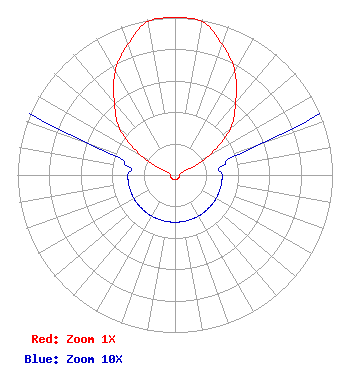 | ||||||||||||||||||
| Azimuth | Ratio | Azimuth | Ratio | Azimuth | Ratio | Azimuth | Ratio | ||||||||||||
| 0 | 1.000 | 10 | 0.990 | 20 | 0.880 | 30 | 0.760 | ||||||||||||
| 40 | 0.600 | 50 | 0.460 | 60 | 0.250 | 70 | 0.060 | ||||||||||||
| 80 | 0.030 | 90 | 0.030 | 100 | 0.030 | 110 | 0.030 | ||||||||||||
| 120 | 0.030 | 130 | 0.030 | 140 | 0.030 | 150 | 0.030 | ||||||||||||
| 160 | 0.030 | 170 | 0.030 | 180 | 0.030 | 190 | 0.030 | ||||||||||||
| 200 | 0.030 | 210 | 0.030 | 220 | 0.030 | 230 | 0.030 | ||||||||||||
| 240 | 0.030 | 250 | 0.030 | 260 | 0.030 | 270 | 0.030 | ||||||||||||
| 280 | 0.030 | 290 | 0.060 | 300 | 0.250 | 310 | 0.460 | ||||||||||||
| 320 | 0.600 | 330 | 0.760 | 340 | 0.880 | 350 | 0.990 | ||||||||||||
Structure Registration Number 1011545 [ASR Heights Differ from DW44CV-D Application] Structure Type: LTOWER Registered To: RADIO REDENTOR INC Structure Address: Road 610, Km. 0.6, Barrio Sabana Grande, Sector San Alonso Utuado, PR County Name: Utuado Municipio ASR Issued: 08/13/2018 Date Built: 01/15/2004 Site Elevation: 615.1 m (2018 ft.) Structure Height: 76 m (249 ft.) Height Overall: 76.8 m (252 ft.) Overall Height AMSL: 691.9 m (2270 ft.) FAA Determination: 08/09/2018 FAA Study #: 2018-ASO-12357-OE FAA Circular #: 70/7460-1L Paint & Light FAA Chapters: 4, 8, 12 Removed expiration date from determination. Scenario 1./jjs/case#635066 18-17-21.9 N 66-39-37.3 W (NAD 83) 18-17-29.1 N 66-39-38.7 W (Converted to NAD 27) |
Po Box 903 Saint Just, PR 00978 Phone: 787-761-2833 Corporation | Title: President Date: 12/07/2017 Application Certifier TV RED DE PUERTO RICO INC Tv Red De Puerto Rico Inc Po Box 903 Saint Just, PR 00978 Applicant JORGE R FIGUEROA Tv Red De Puerto Rico Inc Po Box 903 Saint Just, PR 00978 PRESIDENT GRAFTON I OLIVERA Grafton Olivera, Consulting Engineer 5119 60th Drive E Bradenton, FL 34203 TECHNICAL CONSULTANT | |||||||||||||||||