
FCCInfo.com
A Service of Cavell, Mertz & Associates, Inc.
(855) FCC-INFO
|
|
|
Virtual Channel 10 |  |
|
||||||||||||||||||||||||
|
|
Repacking Information: No changes Status: Construction Permit Application Accepted: 12/06/2017 KSTF CP Expires: 03/05/2023 File Number: -0000036040 FCC Website Links: LMS Facility Details This Application Other KSTF Applications Including Superseded Applications Mailing Address Correspondence for KSTF Correspondence related to application -0000036040 Service Contour - Open Street Map or USGS Map (41 dBu) Service Contour - KML / Google Earth (41 dBu) Public Inspection Files History Cards for KSTF Rabbit Ears Info Search for KSTF Site Location: 41-59-58.4 N 103-40-32.2 W (NAD 83) Site Location: 41-59-58.5 N 103-40-30.4 W (Converted to NAD 27) ERP: 55 kW Polarization: Circularly polarized HAAT: 190.3 m (624 ft.) Electrical Beam Tilt: 0.5 degrees R/C AGL: 145 m (476 ft.) R/C AMSL: 1484.6 m (4871 ft.) Site Elevation: 1339.6 m. (4395 ft.) Height Overall*: 152.1 m (499 ft.) (* As Filed In This Application, may differ from ASR Data, Below.) Directional Antenna - Antenna Make/Model: Electronics Research Inc. ALP16L2-CSOC-29 Antenna ID: 119293 Polarization: Circularly polarized | |||||||||||||||||||||||||||
| Antenna Data for Antenna Id: 119293 KSTF DT File: -0000036040 Electronics Research Inc. - ALP16L2-CSOC-29 Service: DT Standard Pattern: Y | 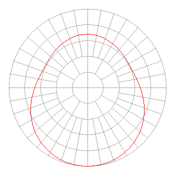 | |||||||||||||||||||||||||||
| Azimuth | Ratio | Azimuth | Ratio | Azimuth | Ratio | Azimuth | Ratio | |||||||||||||||||||||
| 0 | 0.676 | 10 | 0.672 | 20 | 0.659 | 30 | 0.642 | |||||||||||||||||||||
| 40 | 0.623 | 50 | 0.608 | 60 | 0.602 | 70 | 0.609 | |||||||||||||||||||||
| 80 | 0.631 | 90 | 0.668 | 100 | 0.715 | 110 | 0.767 | |||||||||||||||||||||
| 120 | 0.820 | 130 | 0.871 | 140 | 0.915 | 150 | 0.951 | |||||||||||||||||||||
| 160 | 0.978 | 170 | 0.994 | 180 | 1.000 | 190 | 0.994 | |||||||||||||||||||||
| 200 | 0.978 | 210 | 0.951 | 220 | 0.915 | 230 | 0.871 | |||||||||||||||||||||
| 240 | 0.820 | 250 | 0.767 | 260 | 0.715 | 270 | 0.668 | |||||||||||||||||||||
| 280 | 0.631 | 290 | 0.609 | 300 | 0.602 | 310 | 0.608 | |||||||||||||||||||||
| 320 | 0.623 | 330 | 0.642 | 340 | 0.659 | 350 | 0.672 | |||||||||||||||||||||
Structure Registration Number 1025886 Structure Type: GTOWER Registered To: Gray Media Group, Inc. Structure Address: 10141 Highway 71 Scottsbluff, NE County Name: Scotts Bluff County ASR Issued: 09/09/2020 Date Built: 11/03/2014 Site Elevation: 1339.6 m (4395 ft.) Structure Height: 151.5 m (497 ft.) Height Overall: 152.1 m (499 ft.) Overall Height AMSL: 1491.7 m (4894 ft.) FAA Determination: 09/11/2014 FAA Study #: 2014-ACE-3217-OE FAA Circular #: 70/7460-1K Paint & Light FAA Chapters: 4, 6, 12 Removed expiration date from determination. Scenario 1./jjs/case#635066 41-59-58.4 N 103-40-32.2 W (NAD 83) 41-59-58.5 N 103-40-30.4 W (Converted to NAD 27) |
4370 Peachtree Road, Ne Atlanta, GA 30319 Phone: 404-504-9828 Limited Liability Company | Title: Assistant Secretary Date: 12/06/2017 Application Certifier GRAY TELEVISION LICENSEE, LLC Gray Television Licensee, Llc 4370 Peachtree Road, Ne Atlanta, GA 30319 Applicant Joseph M. Davis, P.E. Chesapeake Rf Consultants, Llc 207 Old Dominion Road Yorktown, VA 23692 Consulting Engineer JOAN STEWART Wiley Rein Llp 1776 K Street Nw Washington, DC 20006 | ||||||||||||||||||||||||||
| ||||||||||||||||||||||||||||