
FCCInfo.com
A Service of Cavell, Mertz & Associates, Inc.
(855) FCC-INFO
|
|
WOCW-LD from 05/26/2006 WOCW-LD from 12/04/2002 WOCW-LD from 10/08/1998 WOCW-LD from 07/01/1997 WOCW-LD from 11/21/1994 |
|
|
||||||||||||||||
|
|
Status: STA – Special Temporary Authority Application Accepted: 12/14/2017 STA Expires: 12/25/2017 File Number: -0000036375 FCC Website Links: LMS Facility Details This Application Other WOCW-LD Applications Including Superseded Applications Mailing Address Correspondence for WOCW-LD Correspondence related to application -0000036375 Service Contour - Open Street Map or USGS Map (74 dBu) Service Contour - KML / Google Earth (74 dBu) Rabbit Ears Info Search for WOCW-LD Site Location: 38-22-34.6 N 81-39-23.5 W (NAD 83) Site Location: 38-22-34.3 N 81-39-24.1 W (Converted to NAD 27) ERP: 25 kW R/C AGL: 76 m (249 ft.) R/C AMSL: 368.6 m (1209 ft.) Site Elevation: 292.6 m. (960 ft.) Height Overall*: 100.6 m (330 ft.) (* As Filed In This Application, may differ from ASR Data, Below.) Directional Antenna - Antenna Make/Model: Jampro JA/LS-DC-16 Antenna ID: 19473 | ||||||||||||||||||
| Antenna Data for Antenna Id: 19473 WOCW-LD TX File: -0000036375 Jampro - JA/LS-DC-16 Service: TX Standard Pattern: Y Pattern and Field Values Include a 270° Clockwise Rotation | 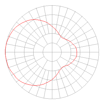 | ||||||||||||||||||
| Azimuth | Ratio | Azimuth | Ratio | Azimuth | Ratio | Azimuth | Ratio | ||||||||||||
| 0 | 0.550 | 10 | 0.480 | 20 | 0.420 | 30 | 0.380 | ||||||||||||
| 40 | 0.380 | 50 | 0.410 | 60 | 0.450 | 70 | 0.480 | ||||||||||||
| 80 | 0.520 | 90 | 0.530 | 100 | 0.530 | 110 | 0.500 | ||||||||||||
| 120 | 0.470 | 130 | 0.440 | 140 | 0.400 | 150 | 0.400 | ||||||||||||
| 160 | 0.440 | 170 | 0.510 | 180 | 0.590 | 190 | 0.670 | ||||||||||||
| 200 | 0.750 | 210 | 0.820 | 220 | 0.880 | 230 | 0.930 | ||||||||||||
| 240 | 0.950 | 250 | 0.980 | 260 | 0.990 | 270 | 1.000 | ||||||||||||
| 280 | 0.990 | 290 | 0.970 | 300 | 0.950 | 310 | 0.910 | ||||||||||||
| 320 | 0.860 | 330 | 0.800 | 340 | 0.720 | 350 | 0.640 | ||||||||||||
Structure Registration Number 1238159 Structure Type: TOWER Registered To: West Virginia Educational Broadcasting Authority Structure Address: 0.3 Mi. Se Of Intersection Of Hwy 622 And Chandlers Drive Charleston, WV County Name: Kanawha County ASR Issued: 03/24/2003 Date Built: 03/15/2004 Site Elevation: 292.6 m (960 ft.) Structure Height: 100.6 m (330 ft.) Height Overall: 100.6 m (330 ft.) Overall Height AMSL: 393.2 m (1290 ft.) FAA Determination: 11/27/2002 FAA Study #: 2002-AEA-1923-OE FAA Circular #: 70/7460-1K Paint & Light FAA Chapters: 3, 4, 5, 12 PRIOR STUDY 1999-AEA-1738-OE 38-22-34.6 N 81-39-23.5 W (NAD 83) 38-22-34.3 N 81-39-24.1 W (Converted to NAD 27) |
295 Madison Avenue, 12th Floor New York, NY 10017 Phone: 954-606-5486 Corporation | Title: Chief Legal Officer And Corporate Secretary Date: 12/14/2017 Application Certifier Dtv America Corporation 1671 Nw 144th Terrace, Suite 110 Sunrise, FL 33323 Applicant C. Sean Spivey Hogan Lovells Us Llp 555 13th St, Nw Washington, DC 20004 RENEE ILHARDT Dtv America Corporation 1671 Nw 144th Terrace, Suite 110 Sunrise, FL 33323 | |||||||||||||||||