
FCCInfo.com
A Service of Cavell, Mertz & Associates, Inc.
(855) FCC-INFO
|
|
KWTC-LD from 08/17/1998 KWTC-LD from 11/30/1984 |
|
|
||||||||||||||||
|
|
Status: License Application Accepted: 12/12/2017 License Expires: 08/01/2022 File Number: -0000036258 FCC Website Links: LMS Facility Details This Application Other KWTC-LD Applications Including Superseded Applications Mailing Address Correspondence for KWTC-LD Correspondence related to application -0000036258 Service Contour - Open Street Map or USGS Map (51 dBu) Service Contour - KML / Google Earth (51 dBu) Rabbit Ears Info Search for KWTC-LD Site Location: 30-12-14.0 N 98-46-43.0 W (NAD 83) Site Location: 30-12-13.3 N 98-46-41.9 W (Converted to NAD 27) ERP: 15 kW Polarization: Horizontally polarized R/C AGL: 70 m (230 ft.) R/C AMSL: 611.3 m (2006 ft.) Emission Mask: Full Service Site Elevation: 541.3 m. (1776 ft.) Height Overall*: 97.5 m (320 ft.) (* As Filed In This Application, may differ from ASR Data, Below.) Directional Antenna - Antenna Make/Model: Scala PR-450 Array Antenna ID: 1002744 Polarization: Horizontally polarized
| ||||||||||||||||||
| Antenna Data for Antenna Id: 1002744 KWTC-LD LD File: -0000036258 Scala - PR-450 Array Service: LD Standard Pattern: N Pattern and Field Values Include a 60° Clockwise Rotation | 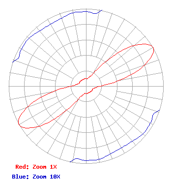 | ||||||||||||||||||
| Azimuth | Ratio | Azimuth | Ratio | Azimuth | Ratio | Azimuth | Ratio | ||||||||||||
| 0 | 0.096 | 10 | 0.097 | 20 | 0.125 | 30 | 0.190 | ||||||||||||
| 40 | 0.447 | 50 | 0.814 | 60 | 1.000 | 70 | 0.814 | ||||||||||||
| 80 | 0.447 | 90 | 0.190 | 100 | 0.125 | 110 | 0.097 | ||||||||||||
| 120 | 0.096 | 130 | 0.096 | 140 | 0.093 | 150 | 0.092 | ||||||||||||
| 160 | 0.093 | 170 | 0.096 | 180 | 0.096 | 190 | 0.097 | ||||||||||||
| 200 | 0.125 | 210 | 0.190 | 220 | 0.447 | 230 | 0.814 | ||||||||||||
| 240 | 1.000 | 250 | 0.814 | 260 | 0.447 | 270 | 0.190 | ||||||||||||
| 280 | 0.125 | 290 | 0.097 | 300 | 0.096 | 310 | 0.096 | ||||||||||||
| 320 | 0.093 | 330 | 0.092 | 340 | 0.093 | 350 | 0.096 | ||||||||||||
Structure Registration Number 1215628 Structure Type: TOWER Registered To: Global Tower, LLC. through American Towers, LLC Structure Address: 705 Arlit Road Fredericksburg, TX County Name: Gillespie County ASR Issued: 09/02/2014 Date Built: 07/05/2000 Site Elevation: 541.3 m (1776 ft.) Structure Height: 79.2 m (260 ft.) Height Overall: 97.5 m (320 ft.) Overall Height AMSL: 638.8 m (2096 ft.) FAA Determination: 04/04/2000 FAA Study #: 00-ASW-0562-OE FAA Circular #: 70/7460-1K Paint & Light FAA Chapters: 4, 8, 12 Removed expiration date from determination. Scenario 1./jjs/case#635066 30-12-14.0 N 98-46-43.0 W (NAD 83) 30-12-13.3 N 98-46-41.9 W (Converted to NAD 27) |
Hurst, TX 76054-4025 Phone: 214-770-7770 Corporation | Title: Director Date: 12/12/2017 Application Certifier THE EDGE SPECTRUM, INC. The Edge Spectrum, Inc. 7829 Center Blvd. Se No. 190 Snoqualmie, WA 98065 Applicant Byron W St. Clair B.w. St. Clair 2355 Ranch Drive Westminster, CO 80234 Engineering Consultant | |||||||||||||||||