
FCCInfo.com
A Service of Cavell, Mertz & Associates, Inc.
(855) FCC-INFO
|
|
DWOTH-CD from 07/01/2013 DWOTH-CD from 02/07/2011 DWOTH-CD from 04/02/2010 DWOTH-CD from 08/13/2007 |
RF spectrum relinquished in the spectrum auction |  |
|
|||||||||||||||
|
|
Repacking Information: Channel 20 was relinquished in the spectrum auction Status: License Application Accepted: 02/20/2018 License Expires: 10/01/2021 File Number: -0000042552 FCC Website Links: LMS Facility Details This Application Other DWOTH-CD Applications Including Superseded Applications Mailing Address Correspondence for DWOTH-CD Correspondence related to application -0000042552 Service Contour - Open Street Map or USGS Map (51 dBu) Service Contour - KML / Google Earth (51 dBu) Public Inspection Files Rabbit Ears Info Search for DWOTH-CD Site Location: 39-07-30.4 N 84-29-56.0 W (NAD 83) Site Location: 39-07-30.2 N 84-29-56.2 W (Converted to NAD 27) ERP: 15 kW Electrical Beam Tilt: 1 degree R/C AGL: 207 m (679 ft.) R/C AMSL: 464.3 m (1523 ft.) Emission Mask: Stringent Site Elevation: 257.3 m. (844 ft.) Height Overall*: 263.9 m (866 ft.) (* As Filed In This Application, may differ from ASR Data, Below.) Directional Antenna - Antenna Make/Model: Scala SL-8 Antenna ID: 23503 | ||||||||||||||||||
| Antenna Data for Antenna Id: 23503 DWOTH-CD DC File: -0000042552 Scala - SL-8 Service: DC Standard Pattern: Y | 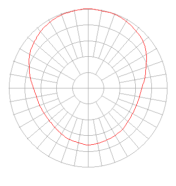 | ||||||||||||||||||
| Azimuth | Ratio | Azimuth | Ratio | Azimuth | Ratio | Azimuth | Ratio | ||||||||||||
| 0 | 1.000 | 10 | 0.990 | 20 | 0.990 | 30 | 0.970 | ||||||||||||
| 40 | 0.940 | 50 | 0.910 | 60 | 0.850 | 70 | 0.780 | ||||||||||||
| 80 | 0.730 | 90 | 0.680 | 100 | 0.660 | 110 | 0.650 | ||||||||||||
| 120 | 0.650 | 130 | 0.660 | 140 | 0.680 | 150 | 0.690 | ||||||||||||
| 160 | 0.700 | 170 | 0.710 | 180 | 0.720 | 190 | 0.700 | ||||||||||||
| 200 | 0.690 | 210 | 0.670 | 220 | 0.650 | 230 | 0.640 | ||||||||||||
| 240 | 0.640 | 250 | 0.650 | 260 | 0.660 | 270 | 0.690 | ||||||||||||
| 280 | 0.740 | 290 | 0.790 | 300 | 0.850 | 310 | 0.890 | ||||||||||||
| 320 | 0.930 | 330 | 0.960 | 340 | 0.980 | 350 | 0.990 | ||||||||||||
Structure Registration Number 1013618 Structure Type: TOWER Registered To: SCRIPPS MEDIA, INC. Structure Address: 2345 Symmes St Cincinnati, OH County Name: Hamilton County ASR Issued: 09/11/2013 Date Built: 12/16/2010 Site Elevation: 257.3 m (844 ft.) Structure Height: 241.1 m (791 ft.) Height Overall: 263.9 m (866 ft.) Overall Height AMSL: 521.2 m (1710 ft.) FAA Determination: 07/01/2011 FAA Study #: 2011-AGL-3332-OE FAA Circular #: 70/7460-1J Paint & Light FAA Chapters: 3, 4, 5, 13 OM&L to remain the same as prior study = PAINT/RED LIGHTS 39-07-30.4 N 84-29-56.0 W (NAD 83) 39-07-30.2 N 84-29-56.2 W (Converted to NAD 27) |
Cincinnati, OH 45222 Phone: 513-631-8825 Individual | Title: Station Manager Date: 02/19/2018 Application Certifier ELLIOTT B. BLOCK P.o. Box 37770 Cincinnati, OH 45222 Applicant Matthew Gray Block Broadcasting Company Cincinnati, OH 45222 JEFFREY REYNOLDS Dutreil, Lundin & Rackley, Inc. 201 Fletcher Ave. Sarasota, FL 34237 CONSULTING ENGINEER KATHLEEN VICTORY Fletcher, Heald & Hildreth, P.l.c. 1300 N. 17th St. 11th Floor Arlington, VA 22209 ATTORNEY | |||||||||||||||||