
FCCInfo.com
A Service of Cavell, Mertz & Associates, Inc.
(855) FCC-INFO
|
|
WVGN-LD from 08/18/2003 WVGN-LD from 10/04/2001 |
|
|
||||||||||||||||
|
|
Status: License Application Accepted: 03/15/2018 License Expires: 02/01/2021 File Number: -0000048749 FCC Website Links: LMS Facility Details This Application Other WVGN-LD Applications Including Superseded Applications Mailing Address Correspondence for WVGN-LD Correspondence related to application -0000048749 Service Contour - Open Street Map or USGS Map (51 dBu) Service Contour - KML / Google Earth (51 dBu) Rabbit Ears Info Search for WVGN-LD Site Location: 18-21-19.0 N 64-56-49.0 W (NAD 83) Site Location: 18-21-26.2 N 64-56-50.5 W (Converted to NAD 27) ERP: 3.25 kW Polarization: Horizontally polarized Electrical Beam Tilt: 0.25 degrees R/C AGL: 12.5 m (41 ft.) R/C AMSL: 463.6 m (1521 ft.) Emission Mask: Stringent Site Elevation: 451.1 m. (1480 ft.) Height Overall*: 35.1 m (115 ft.) (* As Filed In This Application, may differ from ASR Data, Below.) Directional Antenna - Antenna Make/Model: Electronics Research Inc. ALP8L1-HSMR-19 Antenna ID: 102362 Polarization: Horizontally polarized | ||||||||||||||||||
| Antenna Data for Antenna Id: 102362 WVGN-LD LD File: -0000048749 Electronics Research Inc. - ALP8L1-HSMR-19 Service: LD Standard Pattern: Y Pattern and Field Values Include a 100° Clockwise Rotation | 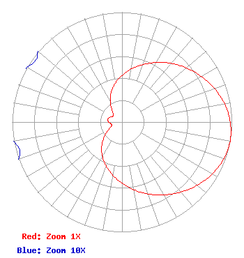 | ||||||||||||||||||
| Azimuth | Ratio | Azimuth | Ratio | Azimuth | Ratio | Azimuth | Ratio | ||||||||||||
| 0 | 0.425 | 10 | 0.490 | 20 | 0.556 | 30 | 0.626 | ||||||||||||
| 40 | 0.698 | 50 | 0.767 | 60 | 0.832 | 70 | 0.895 | ||||||||||||
| 80 | 0.949 | 90 | 0.985 | 100 | 1.000 | 110 | 0.985 | ||||||||||||
| 120 | 0.949 | 130 | 0.895 | 140 | 0.832 | 150 | 0.767 | ||||||||||||
| 160 | 0.698 | 170 | 0.626 | 180 | 0.556 | 190 | 0.490 | ||||||||||||
| 200 | 0.425 | 210 | 0.358 | 220 | 0.287 | 230 | 0.212 | ||||||||||||
| 240 | 0.141 | 250 | 0.101 | 260 | 0.100 | 270 | 0.122 | ||||||||||||
| 280 | 0.132 | 290 | 0.122 | 300 | 0.100 | 310 | 0.101 | ||||||||||||
| 320 | 0.141 | 330 | 0.212 | 340 | 0.287 | 350 | 0.358 | ||||||||||||
Structure Registration Number 1024797 Structure Type: TOWER Registered To: VIRGIN ISLANDS PUBLIC TELEVISION SYSTEM Structure Address: Signal Hill Charlotte Amalie, VI County Name: St. Thomas Island ASR Issued: 08/07/1997 Date Built: 01/01/1972 Site Elevation: 451.1 m (1480 ft.) Structure Height: 30.5 m (100 ft.) Height Overall: 35.1 m (115 ft.) Overall Height AMSL: 486.2 m (1595 ft.) FAA Determination: 11/02/1985 FAA Study #: 85-SJU-37-OE Paint & Light FAA Chapters: 1, 2 RED LIGHTS/PAINT 18-21-19.0 N 64-56-49.0 W (NAD 83) 18-21-26.2 N 64-56-50.5 W (Converted to NAD 27) |
6380 Wilshire Blvd. Suite 1604 Los Angeles, CA 90048 Phone: 323-930-1908 Corporation | Title: President Date: 03/15/2018 Application Certifier LKK GROUP CORPORATION Lkk Group Corporation 6380 Wilshire Blvd. Suite 1604 Los Angeles, CA 90048 Applicant Stephen Hartzell Brooks, Pierce Et Al. 150 Fayetteville Street Suite 1700 Raleigh, NC 27601 Timothy G Nelson Brooks, Pierce Et Al. 150 Fayetteville Street Suite 1700 Raleigh, NC 27601 | |||||||||||||||||