
FCCInfo.com
A Service of Cavell, Mertz & Associates, Inc.
(855) FCC-INFO
|
|
K26NL-D from 01/12/2007 |
|
|
||||||||||||||||
|
|
Status: License Application Accepted: 07/13/2018 License Expires: 10/03/2022 File Number: -0000058315 FCC Website Links: LMS Facility Details This Application Other K26NL-D Applications Including Superseded Applications Mailing Address Correspondence for K26NL-D Correspondence related to application -0000058315 Service Contour - Open Street Map or USGS Map (51 dBu) Service Contour - KML / Google Earth (51 dBu) Rabbit Ears Info Search for K26NL-D Site Location: 44-18-17.0 N 105-33-55.0 W (NAD 83) Site Location: 44-18-17.1 N 105-33-53.0 W (Converted to NAD 27) ERP: 5.8 kW Polarization: Horizontally polarized Electrical Beam Tilt: 1.75 degrees R/C AGL: 18 m (59 ft.) R/C AMSL: 1509.7 m (4953 ft.) Emission Mask: Simple Site Elevation: 1491.7 m. (4894 ft.) Height Overall*: 21.3 m (70 ft.) (* As Filed In This Application, may differ from ASR Data, Below.) Directional Antenna - Antenna Make/Model: Scala SL-8 Antenna ID: 1003937 Polarization: Horizontally polarized
| ||||||||||||||||||
| Antenna Data for Antenna Id: 1003937 K26NL-D LD File: -0000058315 Scala - SL-8 Service: LD Standard Pattern: N Pattern and Field Values Include a 90° Clockwise Rotation | 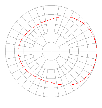 | ||||||||||||||||||
| Azimuth | Ratio | Azimuth | Ratio | Azimuth | Ratio | Azimuth | Ratio | ||||||||||||
| 0 | 0.690 | 10 | 0.740 | 20 | 0.790 | 30 | 0.850 | ||||||||||||
| 40 | 0.890 | 50 | 0.930 | 60 | 0.960 | 70 | 0.980 | ||||||||||||
| 80 | 0.990 | 90 | 1.000 | 100 | 0.990 | 110 | 0.990 | ||||||||||||
| 120 | 0.970 | 130 | 0.940 | 140 | 0.910 | 150 | 0.850 | ||||||||||||
| 160 | 0.780 | 170 | 0.730 | 180 | 0.680 | 190 | 0.660 | ||||||||||||
| 200 | 0.650 | 210 | 0.650 | 220 | 0.660 | 230 | 0.680 | ||||||||||||
| 240 | 0.690 | 250 | 0.700 | 260 | 0.710 | 270 | 0.720 | ||||||||||||
| 280 | 0.700 | 290 | 0.690 | 300 | 0.670 | 310 | 0.650 | ||||||||||||
| 320 | 0.640 | 330 | 0.640 | 340 | 0.650 | 350 | 0.660 | ||||||||||||
Structure Registration Number 1008911 Structure Type: TOWER Registered To: CENTRAL WYOMING COLLEGE DBA = WYOMING PUBLIC TELEVISION Structure Address: .67 Mi N Of I-90 1.75 Mi E Of Us 14 & 16 Gillette, WY County Name: Campbell County ASR Issued: 12/19/2006 Date Built: 01/13/1991 Site Elevation: 1491.7 m (4894 ft.) Structure Height: 15.2 m (50 ft.) Height Overall: 21.3 m (70 ft.) Overall Height AMSL: 1513 m (4964 ft.) FAA Determination: 12/08/1988 FAA Study #: 88-ANM-0295-OE FAA Circular #: 70/7460-1G Paint & Light FAA Chapters: 5, 9 44-18-17.0 N 105-33-55.0 W (NAD 83) 44-18-17.1 N 105-33-53.0 W (Converted to NAD 27) |
2660 Peck Ave Riverton, WY 82501 Phone: 307-856-6944 Applicant | Title: General Manager Date: 07/13/2018 Application Certifier CENTRAL WYOMING COLLEGE Central Wyoming College 2660 Peck Ave Riverton, WY 82501 Applicant ANNE GOODWIN CRUMP Fletcher, Heald & Hildreth, P.l.c. 1300 N 17th St Eleventh Flr Arlington, VA 22209 COMMUNICATIONS COUNSEL LONNY FAIRFIELD Central Wyoming College - Wyoming Public Tv 2660 Peck Ave Riverton, WY 82501 ERIK C SWANSON, PE Hatfield & Dawson 9500 Greenwood Ave N Seattle, WA 98103 CONSULTING ENGINEER | |||||||||||||||||