
FCCInfo.com
A Service of Cavell, Mertz & Associates, Inc.
(855) FCC-INFO
|
|
K15LB-D from 10/26/2010 K15LB-D from 07/14/2004 |
|
|
||||||||||||||||
|
|
Status: License Application Accepted: 10/02/2018 License Expires: 04/01/2022 File Number: -0000060222 FCC Website Links: LMS Facility Details This Application Other K15LB-D Applications Including Superseded Applications Mailing Address Correspondence for K15LB-D Correspondence related to application -0000060222 Service Contour - Open Street Map or USGS Map (51 dBu) Service Contour - KML / Google Earth (51 dBu) Rabbit Ears Info Search for K15LB-D Site Location: 45-07-18.8 N 109-16-13.6 W (NAD 83) Site Location: 45-07-19.0 N 109-16-11.0 W (Converted to NAD 27) ERP: 0.076 kW Polarization: Horizontally polarized R/C AGL: 7 m (23 ft.) R/C AMSL: 2098.2 m (6884 ft.) Emission Mask: Simple Site Elevation: 2091.2 m. (6861 ft.) Height Overall*: 13.7 m (45 ft.) (* As Filed In This Application, may differ from ASR Data, Below.) Directional Antenna - Antenna Make/Model: Scala 1X3K723147 Antenna ID: 1004192 Polarization: Horizontally polarized
| ||||||||||||||||||
| Antenna Data for Antenna Id: 1004192 K15LB-D LD File: -0000060222 Scala - 1X3K723147 Service: LD Standard Pattern: N | 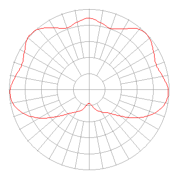 | ||||||||||||||||||
| Azimuth | Ratio | Azimuth | Ratio | Azimuth | Ratio | Azimuth | Ratio | ||||||||||||
| 0 | 0.885 | 10 | 0.843 | 20 | 0.805 | 30 | 0.871 | ||||||||||||
| 40 | 0.975 | 50 | 0.986 | 60 | 0.930 | 70 | 0.892 | ||||||||||||
| 80 | 0.932 | 90 | 0.987 | 100 | 0.970 | 110 | 0.869 | ||||||||||||
| 120 | 0.706 | 130 | 0.518 | 140 | 0.383 | 150 | 0.327 | ||||||||||||
| 160 | 0.273 | 170 | 0.204 | 180 | 0.172 | 190 | 0.206 | ||||||||||||
| 200 | 0.275 | 210 | 0.325 | 220 | 0.392 | 230 | 0.527 | ||||||||||||
| 240 | 0.712 | 250 | 0.872 | 260 | 0.969 | 270 | 0.983 | ||||||||||||
| 280 | 0.932 | 290 | 0.892 | 300 | 0.931 | 310 | 0.998 | ||||||||||||
| 312 | 1.000 | 320 | 0.977 | 330 | 0.881 | 340 | 0.813 | ||||||||||||
| 350 | 0.848 | ||||||||||||||||||
Structure Registration Number 1244479 Structure Type: TOWER Registered To: Montana State University Billings Structure Address: Yellowstone-bighorn Research Assn Permanent Campsite Red Lodge, MT County Name: Carbon County ASR Issued: 11/20/2012 Date Built: 09/01/2005 Site Elevation: 2091.2 m (6861 ft.) Structure Height: 6.1 m (20 ft.) Height Overall: 13.7 m (45 ft.) Overall Height AMSL: 2104.9 m (6906 ft.) FAA Determination: 06/06/2007 FAA Study #: 2007-ANM-1448-OE Paint & Light FAA Chapters: NONE PRIOR STUDY 2004-ANM-344-OE 45-07-18.8 N 109-16-13.6 W (NAD 83) 45-07-19.0 N 109-16-11.0 W (Converted to NAD 27) |
C/o Scripps Media, Inc. 312 Walnut St 28th Floor Cincinnati, OH 45202 Limited Liability Company | Title: Vice President And Manager Date: 10/02/2018 Application Certifier KTVQ COMMUNICATIONS, LLC Ktvq Communications, Llc 3203 Third Avenue North Billings, MT 59101 Applicant Christina H. Burrow Cooley Llp 1299 Pennsylvania Avenue, Nw Suite 700 Washington, DC 20004 Legal Representative Donald G. Everist Cohen, Dippell And Everist, P.c. 1420 N. Street, Nw Suite One Washington, DC 20005 Technical Representative Mark Huller Ktvq Communications, Llc 3203 Third Avenue Billings, MT 59101 CHIEF ENGINEER | |||||||||||||||||