
FCCInfo.com
A Service of Cavell, Mertz & Associates, Inc.
(855) FCC-INFO
|
|
W19EN-D from 10/16/2018 W19EN-D from 11/10/2008 W19EN-D from 06/04/2004 |
|
|
||||||||||||||||
|
|
Status: License Application Accepted: 10/04/2018 License Expires: 12/01/2021 File Number: -0000060427 FCC Website Links: LMS Facility Details This Application Other W19EN-D Applications Including Superseded Applications Mailing Address Correspondence for W19EN-D Correspondence related to application -0000060427 Service Contour - Open Street Map or USGS Map (51 dBu) Service Contour - KML / Google Earth (51 dBu) Rabbit Ears Info Search for W19EN-D Site Location: 44-54-10.0 N 92-41-28.0 W (NAD 83) Site Location: 44-54-10.1 N 92-41-27.3 W (Converted to NAD 27) ERP: 6 kW Polarization: Horizontally polarized Electrical Beam Tilt: 0.25 degrees R/C AGL: 99 m (325 ft.) R/C AMSL: 416 m (1365 ft.) Emission Mask: Full Service Site Elevation: 317 m. (1040 ft.) Height Overall*: 112.2 m (368 ft.) (* As Filed In This Application, may differ from ASR Data, Below.) Directional Antenna - Antenna Make/Model: Electronics Research Inc. ALP8L1-HSH-19 Antenna ID: 1004196 Polarization: Horizontally polarized
| ||||||||||||||||||
| Antenna Data for Antenna Id: 1004196 W19EN-D LD File: -0000060427 Electronics Research Inc. - ALP8L1-HSH-19 Service: LD Standard Pattern: N | 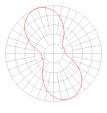 | ||||||||||||||||||
| Azimuth | Ratio | Azimuth | Ratio | Azimuth | Ratio | Azimuth | Ratio | ||||||||||||
| 0 | 0.889 | 10 | 0.764 | 20 | 0.600 | 30 | 0.432 | ||||||||||||
| 40 | 0.302 | 50 | 0.242 | 60 | 0.237 | 70 | 0.242 | ||||||||||||
| 80 | 0.237 | 90 | 0.242 | 100 | 0.302 | 110 | 0.432 | ||||||||||||
| 120 | 0.600 | 130 | 0.764 | 140 | 0.889 | 150 | 0.967 | ||||||||||||
| 160 | 1.000 | 170 | 0.974 | 180 | 0.897 | 190 | 0.781 | ||||||||||||
| 200 | 0.622 | 210 | 0.451 | 220 | 0.324 | 230 | 0.258 | ||||||||||||
| 240 | 0.248 | 250 | 0.256 | 260 | 0.248 | 270 | 0.258 | ||||||||||||
| 280 | 0.324 | 290 | 0.451 | 300 | 0.622 | 310 | 0.781 | ||||||||||||
| 320 | 0.897 | 330 | 0.974 | 340 | 1.000 | 350 | 0.967 | ||||||||||||
Structure Registration Number 1042738 Structure Type: GTOWER Registered To: Great Rivers Wireless, LLC Structure Address: 1.9 Mi N Of Cty Rd Mm 1.6 Mi W Of Hwy 35 River Falls, WI County Name: St. Croix County ASR Issued: 12/23/2021 Date Built: 03/21/2020 Site Elevation: 317 m (1040 ft.) Structure Height: 106.7 m (350 ft.) Height Overall: 112.2 m (368 ft.) Overall Height AMSL: 429.2 m (1408 ft.) FAA Determination: 12/18/2019 FAA Study #: 2019-AGL-18200-OE Paint & Light FAA Chapters: 1, 3, 12, 21 PRIOR STUDY 2019-AGL-14982-OE 44-54-10.0 N 92-41-23.8 W (NAD 83) 44-54-10.1 N 92-41-23.1 W (Converted to NAD 27) |
3319 W. Beltline Hwy. Madison, WI 53713 Phone: 608-264-9600 Government Entity | Title: Executive Director Date: 10/04/2018 Application Certifier STATE OF WISCONSIN - EDUCATIONAL COMMUNICATIONS BOARD State Of Wisconsin - Educational Communications Board 3319 W. Beltline Hwy. Madison, WI 53713 Applicant Jeffrey D Ohnstad State Of Wisconsin - Educational 3319 W. Beltline Hwy. Madison, WI 53713 STAFF ENGINEER Barry S Persh Gray Miller Persh Llp 1200 New Hampshire Av Nw Washington, DC 20036 Dennis Wallace Meintel, Sgrignoli, & Wallace, Llc 1282 Smallwood Drive Suite 372 Waldorf, MD 20603 Technical Consultant | |||||||||||||||||