
FCCInfo.com
A Service of Cavell, Mertz & Associates, Inc.
(855) FCC-INFO
|
|
K31OQ-D from 11/13/2018 K31OQ-D from 10/27/2009 K31OQ-D from 09/17/1991 K31OQ-D from 12/18/1989 K31OQ-D from 12/04/1987 |
|
|
||||||||||||||||
|
|
Status: License Application Accepted: 11/01/2018 License Expires: 02/01/2023 File Number: -0000063274 FCC Website Links: LMS Facility Details This Application Other K31OQ-D Applications Including Superseded Applications Mailing Address Correspondence for K31OQ-D Correspondence related to application -0000063274 Service Contour - Open Street Map or USGS Map (51 dBu) Service Contour - KML / Google Earth (51 dBu) Rabbit Ears Info Search for K31OQ-D Site Location: 42-24-42.5 N 123-16-58.5 W (NAD 83) Site Location: 42-24-43.1 N 123-16-54.3 W (Converted to NAD 27) ERP: 1.5 kW Polarization: Horizontally polarized Electrical Beam Tilt: 3 degrees R/C AGL: 21.3 m (70 ft.) R/C AMSL: 855.2 m (2806 ft.) Emission Mask: Full Service Site Elevation: 833.9 m. (2736 ft.) Height Overall*: 38.1 m (125 ft.) (* As Filed In This Application, may differ from ASR Data, Below.) Directional Antenna - Antenna Make/Model: Kathrein SL-8 (SP-12681) Antenna ID: 1004295 Polarization: Horizontally polarized
| ||||||||||||||||||
| Antenna Data for Antenna Id: 1004295 K31OQ-D LD File: -0000063274 Kathrein - SL-8 (SP-12681) Service: LD Standard Pattern: N Pattern and Field Values Include a 330° Clockwise Rotation | 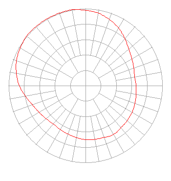 | ||||||||||||||||||
| Azimuth | Ratio | Azimuth | Ratio | Azimuth | Ratio | Azimuth | Ratio | ||||||||||||
| 0 | 0.977 | 10 | 0.955 | 20 | 0.912 | 30 | 0.861 | ||||||||||||
| 40 | 0.794 | 50 | 0.733 | 60 | 0.696 | 70 | 0.668 | ||||||||||||
| 80 | 0.649 | 90 | 0.657 | 100 | 0.668 | 110 | 0.684 | ||||||||||||
| 120 | 0.700 | 130 | 0.708 | 140 | 0.716 | 150 | 0.733 | ||||||||||||
| 160 | 0.716 | 170 | 0.708 | 180 | 0.700 | 190 | 0.684 | ||||||||||||
| 200 | 0.668 | 210 | 0.657 | 220 | 0.649 | 230 | 0.668 | ||||||||||||
| 240 | 0.696 | 250 | 0.733 | 260 | 0.794 | 270 | 0.861 | ||||||||||||
| 280 | 0.912 | 290 | 0.955 | 300 | 0.977 | 310 | 1.000 | ||||||||||||
| 320 | 1.000 | 330 | 1.000 | 340 | 1.000 | 350 | 1.000 | ||||||||||||
Structure Registration Number 1229002 Structure Type: TOWER Registered To: CALIFORNIA OREGON BROADCASTING, INC Structure Address: Town Of Applegate, Or Applegate, OR County Name: Josephine County ASR Issued: 08/20/2008 Date Built: 10/16/2000 Site Elevation: 833.9 m (2736 ft.) Structure Height: 38.1 m (125 ft.) Height Overall: 38.1 m (125 ft.) Overall Height AMSL: 872 m (2861 ft.) FAA Determination: 08/15/2001 FAA Study #: 01-ANM-2583-OE FAA Circular #: 70/7460-1K Paint & Light FAA Chapters: 4, 5, 12 Removed expiration date from determination. Scenario 1./jjs/case#635066 42-24-42.5 N 123-16-58.5 W (NAD 83) 42-24-43.1 N 123-16-54.3 W (Converted to NAD 27) |
P. O. Box 1489 Medford, OR 97501 Phone: 541-779-5555 Corporation | Title: President Date: 11/01/2018 Application Certifier California Oregon Broadcasting, Inc. P. O. Box 1489 Medford, OR 97501 Applicant Kathleen Kirby Wiley Rein Llp 1776 K Street, Nw Washington, DC 20006 KARL SARGENT California Oregon Broadcasting, Inc. California Oregon Broadcasting, Inc. 125 S. Fir Street Medford, OR 97501 DIRECTOR OF ENGINEERING Scott Turpie Lohnes & Culver Llc Silver Spring, MD 20918 Technical Consultant | |||||||||||||||||