
FCCInfo.com
A Service of Cavell, Mertz & Associates, Inc.
(855) FCC-INFO
|
|
K18MB-D from 12/13/2018 K18MB-D from 08/09/2010 K18MB-D from 03/22/1988 |
|
|
||||||||||||||||
|
|
Status: License Application Accepted: 11/30/2018 License Expires: 04/01/2022 File Number: -0000063839 FCC Website Links: LMS Facility Details This Application Other K18MB-D Applications Including Superseded Applications Mailing Address Correspondence for K18MB-D Correspondence related to application -0000063839 Service Contour - Open Street Map or USGS Map (51 dBu) Service Contour - KML / Google Earth (51 dBu) Rabbit Ears Info Search for K18MB-D Site Location: 48-34-22.8 N 93-19-21.5 W (NAD 83) Site Location: 48-34-23.0 N 93-19-21.0 W (Converted to NAD 27) ERP: 0.442 kW Polarization: Horizontally polarized R/C AGL: 90.4 m (297 ft.) R/C AMSL: 463.8 m (1522 ft.) Emission Mask: Simple Site Elevation: 373.4 m. (1225 ft.) Height Overall*: 95.1 m (312 ft.) (* As Filed In This Application, may differ from ASR Data, Below.) Directional Antenna - Antenna Make/Model: Scala 4X4K723147 Antenna ID: 93771 Polarization: Horizontally polarized
| ||||||||||||||||||
| Antenna Data for Antenna Id: 93771 K18MB-D LD File: -0000063839 Scala - 4X4K723147 Service: LD Standard Pattern: Y Pattern and Field Values Include a 125° Clockwise Rotation | 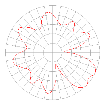 | ||||||||||||||||||
| Azimuth | Ratio | Azimuth | Ratio | Azimuth | Ratio | Azimuth | Ratio | ||||||||||||
| 5 | 0.737 | 15 | 0.620 | 25 | 0.649 | 35 | 0.789 | ||||||||||||
| 45 | 0.635 | 55 | 0.749 | 65 | 0.872 | 75 | 0.650 | ||||||||||||
| 85 | 0.259 | 95 | 0.535 | 105 | 0.881 | 115 | 1.000 | ||||||||||||
| 125 | 0.936 | 135 | 1.000 | 145 | 0.881 | 155 | 0.535 | ||||||||||||
| 165 | 0.259 | 175 | 0.650 | 185 | 0.872 | 195 | 0.749 | ||||||||||||
| 205 | 0.635 | 215 | 0.789 | 225 | 0.649 | 235 | 0.620 | ||||||||||||
| 245 | 0.737 | 255 | 0.855 | 265 | 0.791 | 275 | 0.578 | ||||||||||||
| 285 | 0.578 | 295 | 0.754 | 305 | 0.873 | 315 | 0.754 | ||||||||||||
| 325 | 0.578 | 335 | 0.578 | 345 | 0.791 | 355 | 0.855 | ||||||||||||
Structure Registration Number 1023497 Structure Type: TOWER Registered To: KOOCHICHING, COUNTY OF Structure Address: 3.7 Km East Of Junction Of County Rd 24 And Mn Hwy 332 International Falls, MN County Name: Koochiching County ASR Issued: 10/14/1999 Date Built: 01/01/1959 Site Elevation: 373.4 m (1225 ft.) Structure Height: 94.2 m (309 ft.) Height Overall: 95.1 m (312 ft.) Overall Height AMSL: 468.5 m (1537 ft.) FAA Determination: 12/26/1980 FAA Study #: 80-GL-1452-OE FAA Circular #: 70/7460-1F Paint & Light FAA Chapters: 3, 4, 5, 9 48-34-22.8 N 93-19-21.5 W (NAD 83) 48-34-23.0 N 93-19-21.0 W (Converted to NAD 27) |
715 4th Street International Falls, MN 56649 Phone: 218-283-1152 Government Entity | Title: Operating Engineer Date: 11/30/2018 Application Certifier COUNTY OF KOOCHICHING County Of Koochiching 715 4th Street International Falls, MN 56649 Applicant LEROY HERVEY Voyageurs Comtronics Corporation International Falls, MN 56649 OPERATING ENGINEER | |||||||||||||||||