
FCCInfo.com
A Service of Cavell, Mertz & Associates, Inc.
(855) FCC-INFO
|
|
KLSV-LD from 12/26/2018 KLSV-LD from 10/27/2009 KLSV-LD from 04/10/2001 KLSV-LD from 09/30/1993 KLSV-LD from 09/01/1993 KLSV-LD from 01/07/1993 |
|
|
||||||||||||||||
|
|
Status: License Application Accepted: 12/10/2018 License Expires: 10/03/2022 File Number: -0000064058 FCC Website Links: LMS Facility Details This Application Other KLSV-LD Applications Including Superseded Applications Mailing Address Correspondence for KLSV-LD Correspondence related to application -0000064058 Service Contour - Open Street Map or USGS Map (51 dBu) Service Contour - KML / Google Earth (51 dBu) Rabbit Ears Info Search for KLSV-LD Site Location: 36-00-30.9 N 115-00-21.7 W (NAD 83) Site Location: 36-00-31.0 N 115-00-18.7 W (Converted to NAD 27) ERP: 10 kW Polarization: Horizontally polarized Electrical Beam Tilt: 0.5 degrees R/C AGL: 28.5 m (94 ft.) R/C AMSL: 995.9 m (3267 ft.) Emission Mask: Full Service Site Elevation: 967.4 m. (3174 ft.) Height Overall*: 49.1 m (161 ft.) (* As Filed In This Application, may differ from ASR Data, Below.) Directional Antenna - Antenna Make/Model: Propagation System Inc PSILP8BB Antenna ID: 20484 Polarization: Horizontally polarized | ||||||||||||||||||
| Antenna Data for Antenna Id: 20484 KLSV-LD LD File: -0000064058 Propagation System Inc - PSILP8BB Service: LD Standard Pattern: Y | 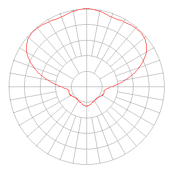 | ||||||||||||||||||
| Azimuth | Ratio | Azimuth | Ratio | Azimuth | Ratio | Azimuth | Ratio | ||||||||||||
| 0 | 1.000 | 10 | 0.980 | 20 | 0.950 | 30 | 0.960 | ||||||||||||
| 40 | 0.980 | 50 | 0.970 | 60 | 0.890 | 70 | 0.720 | ||||||||||||
| 80 | 0.520 | 90 | 0.330 | 100 | 0.240 | 110 | 0.240 | ||||||||||||
| 120 | 0.230 | 130 | 0.210 | 140 | 0.200 | 150 | 0.210 | ||||||||||||
| 160 | 0.220 | 170 | 0.240 | 180 | 0.250 | 190 | 0.240 | ||||||||||||
| 200 | 0.220 | 210 | 0.210 | 220 | 0.200 | 230 | 0.210 | ||||||||||||
| 240 | 0.230 | 250 | 0.240 | 260 | 0.240 | 270 | 0.330 | ||||||||||||
| 280 | 0.520 | 290 | 0.720 | 300 | 0.890 | 310 | 0.970 | ||||||||||||
| 320 | 0.980 | 330 | 0.960 | 340 | 0.950 | 350 | 0.980 | ||||||||||||
Structure Registration Number 1009986 Structure Type: LTOWER Registered To: American Towers LLC Structure Address: Black Mountain Road .7 Miles West Of I-515 (090345 / Black Mountain - Twr 1 Nv) Henderson, NV County Name: Clark County ASR Issued: 06/01/2016 Date Built: 09/29/2002 Site Elevation: 967.4 m (3174 ft.) Structure Height: 47.5 m (156 ft.) Height Overall: 49.1 m (161 ft.) Overall Height AMSL: 1016.5 m (3335 ft.) FAA Determination: 04/19/2016 FAA Study #: 2016-AWP-1630-OE Paint & Light FAA Chapters: NONE PRIOR STUDY 2012-AWP-3011-OE 36-00-30.9 N 115-00-21.7 W (NAD 83) 36-00-31.0 N 115-00-18.7 W (Converted to NAD 27) |
2323 Corinth Avenue West Los Angeles, CA 90064 Phone: 310-943-5288 Corporation | Title: Vice President Date: 12/10/2018 Application Certifier Biltmore Broadcasting Las Vegas, Inc. 2323 Corinth Avenue West Los Angeles, CA 90064 Applicant Jim McDonald B. W. St. Clair 117 East Eleventh St. Loveland, CO 80537 ENGINEERING CONSULTANT BARRY A. FRIEDMAN Thompson Hine Llp Suite 7001 1919 M Street, N.w. Washington, DC 20036 EDDIE HERNANDEZ Kjla, Llc 2323 Corinth Avenue West Los Angeles, CA 90064 DIRECTOR OF ENGINEERING | |||||||||||||||||