
FCCInfo.com
A Service of Cavell, Mertz & Associates, Inc.
(855) FCC-INFO
|
|
W15EE-D from 02/04/2019 W15EE-D from 12/05/2016 W15EE-D from 12/10/2002 |
|
|
|||||||||||||||||||||
|
|
Status: License Application Accepted: 02/01/2019 License Expires: 12/01/2021 File Number: -0000067621 FCC Website Links: LMS Facility Details This Application Other W15EE-D Applications Including Superseded Applications Mailing Address Correspondence for W15EE-D Correspondence related to application -0000067621 Service Contour - Open Street Map or USGS Map (51 dBu) Service Contour - KML / Google Earth (51 dBu) Rabbit Ears Info Search for W15EE-D Site Location: 46-35-23.3 N 90-50-13.3 W (NAD 83) Site Location: 46-35-23.5 N 90-50-12.6 W (Converted to NAD 27) ERP: 4.93 kW Polarization: Horizontally polarized Electrical Beam Tilt: 1.5 degrees R/C AGL: 71.6 m (235 ft.) R/C AMSL: 285 m (935 ft.) Emission Mask: Simple Site Elevation: 213.4 m. (700 ft.) Height Overall*: 126.8 m (416 ft.) (* As Filed In This Application, may differ from ASR Data, Below.) Directional Antenna - Antenna Make/Model: DIELECTRIC DLP8B-15 Antenna ID: 1004605 Polarization: Horizontally polarized
| |||||||||||||||||||||||
| Antenna Data for Antenna Id: 1004605 W15EE-D LD File: -0000067621 DIELECTRIC - DLP8B-15 Service: LD Standard Pattern: N | 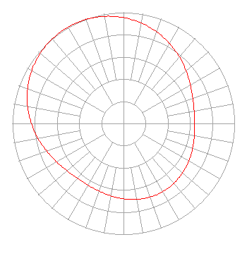 | |||||||||||||||||||||||
| Azimuth | Ratio | Azimuth | Ratio | Azimuth | Ratio | Azimuth | Ratio | |||||||||||||||||
| 0 | 0.953 | 10 | 0.918 | 20 | 0.876 | 30 | 0.829 | |||||||||||||||||
| 40 | 0.781 | 50 | 0.734 | 60 | 0.694 | 70 | 0.663 | |||||||||||||||||
| 80 | 0.645 | 90 | 0.641 | 100 | 0.647 | 110 | 0.661 | |||||||||||||||||
| 120 | 0.679 | 130 | 0.694 | 140 | 0.705 | 150 | 0.709 | |||||||||||||||||
| 160 | 0.705 | 170 | 0.694 | 180 | 0.678 | 190 | 0.661 | |||||||||||||||||
| 200 | 0.647 | 210 | 0.641 | 220 | 0.645 | 230 | 0.663 | |||||||||||||||||
| 240 | 0.694 | 250 | 0.734 | 260 | 0.781 | 270 | 0.829 | |||||||||||||||||
| 280 | 0.876 | 290 | 0.918 | 300 | 0.953 | 310 | 0.979 | |||||||||||||||||
| 320 | 0.995 | 330 | 1.000 | 340 | 0.995 | 350 | 0.979 | |||||||||||||||||
Structure Registration Number 1200096 Structure Type: TOWER Registered To: American Towers LLC Structure Address: Rte 2 Box 74a (ashland #91399) Ashland, WI County Name: Ashland County ASR Issued: 01/15/2013 Date Built: 09/24/2001 Site Elevation: 213.4 m (700 ft.) Structure Height: 121.9 m (400 ft.) Height Overall: 126.8 m (416 ft.) Overall Height AMSL: 340.2 m (1116 ft.) FAA Determination: 10/23/2008 FAA Study #: 2008-AGL-6138-OE FAA Circular #: 70/7460-1K Paint & Light FAA Chapters: 4, 8, 12 PRIOR STUDY 2007-AGL-2248-OE 46-35-23.3 N 90-50-13.3 W (NAD 83) 46-35-23.5 N 90-50-12.6 W (Converted to NAD 27) |
2750 Luberon Lane Cumming, GA 30041 Phone: 678-777-8659 Limited Liability Company | Title: Chief Operating Officer Date: 02/01/2019 Application Certifier KQDS ACQUISITION CORP. Kqds Acquisition Corp. P. O. Box 9115 Fargo, ND 58106 Applicant CHARLES NAFTALIN, ESQ Holland & Knight Llp 800 17th Street, Nw, Suite 1100 Washington, DC 20006 FCC LEGAL COUNSEL | ||||||||||||||||||||||