
FCCInfo.com
A Service of Cavell, Mertz & Associates, Inc.
(855) FCC-INFO
|
|
K26NN-D from 02/12/2019 K26NN-D from 06/02/2010 |
|
|
|||||||||||||||||||||
|
|
Status: License Application Accepted: 02/08/2019 License Expires: 04/01/2022 File Number: -0000067771 FCC Website Links: LMS Facility Details This Application Other K26NN-D Applications Including Superseded Applications Mailing Address Correspondence for K26NN-D Correspondence related to application -0000067771 Service Contour - Open Street Map or USGS Map (51 dBu) Service Contour - KML / Google Earth (51 dBu) Rabbit Ears Info Search for K26NN-D Site Location: 45-17-10.2 N 108-56-03.1 W (NAD 83) Site Location: 45-17-10.4 N 108-56-00.6 W (Converted to NAD 27) ERP: 1 kW Polarization: Horizontally polarized R/C AGL: 27.4 m (90 ft.) R/C AMSL: 1318.5 m (4326 ft.) Emission Mask: Stringent Site Elevation: 1291.1 m. (4236 ft.) Height Overall*: 30.5 m (100 ft.) (* As Filed In This Application, may differ from ASR Data, Below.) Directional Antenna - Antenna Make/Model: Scala SL-8 Antenna ID: 23503 Polarization: Horizontally polarized
| |||||||||||||||||||||||
| Antenna Data for Antenna Id: 23503 K26NN-D LD File: -0000067771 Scala - SL-8 Service: LD Standard Pattern: Y Pattern and Field Values Include a 90° Clockwise Rotation | 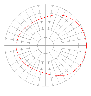 | |||||||||||||||||||||||
| Azimuth | Ratio | Azimuth | Ratio | Azimuth | Ratio | Azimuth | Ratio | |||||||||||||||||
| 0 | 0.690 | 10 | 0.740 | 20 | 0.790 | 30 | 0.850 | |||||||||||||||||
| 40 | 0.890 | 50 | 0.930 | 60 | 0.960 | 70 | 0.980 | |||||||||||||||||
| 80 | 0.990 | 90 | 1.000 | 100 | 0.990 | 110 | 0.990 | |||||||||||||||||
| 120 | 0.970 | 130 | 0.940 | 140 | 0.910 | 150 | 0.850 | |||||||||||||||||
| 160 | 0.780 | 170 | 0.730 | 180 | 0.680 | 190 | 0.660 | |||||||||||||||||
| 200 | 0.650 | 210 | 0.650 | 220 | 0.660 | 230 | 0.680 | |||||||||||||||||
| 240 | 0.690 | 250 | 0.700 | 260 | 0.710 | 270 | 0.720 | |||||||||||||||||
| 280 | 0.700 | 290 | 0.690 | 300 | 0.670 | 310 | 0.650 | |||||||||||||||||
| 320 | 0.640 | 330 | 0.640 | 340 | 0.650 | 350 | 0.660 | |||||||||||||||||
Structure Registration Number 1273045 Structure Type: TOWER Registered To: Clarks Fork Valley TV District #1 Structure Address: 0.7 Miles Sw Of Bridger Municipal Airport Bridger, MT County Name: Carbon County ASR Issued: 02/10/2010 Site Elevation: 1291.1 m (4236 ft.) Structure Height: 30.5 m (100 ft.) Height Overall: 30.5 m (100 ft.) Overall Height AMSL: 1321.6 m (4336 ft.) FAA Determination: 01/07/2010 FAA Study #: 2009-ANM-2219-OE FAA Circular #: 70/7460-1K Paint & Light FAA Chapters: 4, 5, 12 PRIOR STUDY 2007-ANM-186-OE 45-17-10.2 N 108-56-03.1 W (NAD 83) 45-17-10.4 N 108-56-00.6 W (Converted to NAD 27) |
101 W. Broadway Ave. Bridger, MT 59014 Phone: 406-668-7633 Government Entity | Title: Secretary/treasurer Date: 02/08/2019 Application Certifier CLARKS FORK VALLEY TV DISTRICT NO. 1 Clarks Fork Valley Tv District No. 1 101 W. Broadway Ave. Bridger, MT 59014 Applicant LAURA j. CHAMBERS Clarks Fork Valley Tv District No. 1 Po Box 30 Bridger, MT 59014 Susan Hansen B. W. St. Clair 6868 Vivian St. Arvada, CO 80004 ENGINEER | ||||||||||||||||||||||