
FCCInfo.com
A Service of Cavell, Mertz & Associates, Inc.
(855) FCC-INFO
|
|
KILM from 02/07/1992 KILM from 04/10/1985 KILM from 01/18/1984 |
RF spectrum relinquished in the spectrum auction Virtual Channel 64 |  |
|
|||||||||||||||||||||
|
|
KILM is a channel sharing guest of KPXN-TV, San Bernardino, California Repacking Information: Channel 44 was relinquished in the spectrum auction Status: License Application Accepted: 03/26/2019 License Expires: 12/01/2022 File Number: -0000068683 FCC Website Links: LMS Facility Details This Application Other KILM Applications Including Superseded Applications Mailing Address Correspondence for KILM Correspondence related to application -0000068683 Service Contour - Open Street Map or USGS Map (41 dBu) Service Contour - KML / Google Earth (41 dBu) Public Inspection Files Rabbit Ears Info Search for KILM Site Location: 34-13-36.0 N 118-04-02.2 W (NAD 83) Site Location: 34-13-36.0 N 118-03-59.0 W (Converted to NAD 27) ERP: 1000 kW Polarization: Elliptically polarized HAAT: 900 m (2953 ft.) Electrical Beam Tilt: 1.15 degrees R/C AGL: 56.4 m (185 ft.) R/C AMSL: 1790.7 m (5875 ft.) Site Elevation: 1734.3 m. (5690 ft.) Height Overall*: 64 m (210 ft.) (* As Filed In This Application, may differ from ASR Data, Below.) Directional Antenna - Antenna Make/Model: DIELECTRIC TFU-26DSC-R C170 Antenna ID: 1004739 Polarization: Elliptically polarized
| ||||||||||||||||||||||||
| Antenna Data for Antenna Id: 1004739 KILM DT File: -0000068683 DIELECTRIC - TFU-26DSC-R C170 Service: DT Standard Pattern: N | 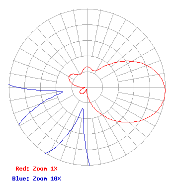 | ||||||||||||||||||||||||
| Azimuth | Ratio | Azimuth | Ratio | Azimuth | Ratio | Azimuth | Ratio | ||||||||||||||||||
| 0 | 0.256 | 10 | 0.246 | 20 | 0.223 | 30 | 0.243 | ||||||||||||||||||
| 40 | 0.342 | 50 | 0.492 | 60 | 0.657 | 70 | 0.810 | ||||||||||||||||||
| 80 | 0.927 | 90 | 0.991 | 95 | 1.000 | 100 | 0.993 | ||||||||||||||||||
| 110 | 0.935 | 120 | 0.832 | 130 | 0.699 | 140 | 0.561 | ||||||||||||||||||
| 150 | 0.422 | 160 | 0.295 | 170 | 0.180 | 180 | 0.086 | ||||||||||||||||||
| 190 | 0.029 | 200 | 0.057 | 210 | 0.095 | 220 | 0.113 | ||||||||||||||||||
| 230 | 0.116 | 240 | 0.103 | 250 | 0.063 | 260 | 0.032 | ||||||||||||||||||
| 270 | 0.089 | 280 | 0.168 | 290 | 0.235 | 300 | 0.265 | ||||||||||||||||||
| 305 | 0.262 | 310 | 0.253 | 320 | 0.211 | 330 | 0.180 | ||||||||||||||||||
| 340 | 0.196 | 350 | 0.235 | ||||||||||||||||||||||
Structure Registration Number 1036897 Structure Type: Registered To: American Towers LLC Structure Address: Tower 19, Mt. Wilson Antenna Farm/25 Km Ne Of Los Angeles, CA County Name: Los Angeles County ASR Issued: 01/05/2021 Date Built: 09/30/1999 Site Elevation: 1734.3 m (5690 ft.) Structure Height: 46 m (151 ft.) Height Overall: 64 m (210 ft.) Overall Height AMSL: 1798.3 m (5900 ft.) FAA Determination: 12/10/1997 FAA Study #: 97-AWP-2875-OE Paint & Light FAA Chapters: NONE 34-13-36.0 N 118-04-02.2 W (NAD 83) 34-13-36.0 N 118-03-59.0 W (Converted to NAD 27) |
312 Walnut Street 28th Floor Cincinnati, OH 45202 Phone: 513-977-3000 Limited Liability Company | Application Certifier KAZN-TV LICENSEE LLC Kazn-tv Licensee Llc 40 Exchange Place 11th Floor New York, NY 10005 Applicant Mark Lipp Fletcher Heald & Hildreth, Plc 1300 North 17th Street 11th Floor Arlington, VA 22209 | |||||||||||||||||||||||