
FCCInfo.com
A Service of Cavell, Mertz & Associates, Inc.
(855) FCC-INFO
|
|
KTBU from 06/22/1995 |
Post-repack Channel 33 Virtual Channel 55 |  |
|
|||||||||||||||
|
|
Repacking Information: Pre-Repack Channel: 42 Post-Repack Channel: 33 Post-Repack ERP: 838 kW Phase: 3 Completion Deadline: 6/21/2019 Find nearby TV Facilities Status: License Application Accepted: 05/01/2019 License Expires: 08/01/2022 File Number: -0000072275 FCC Website Links: LMS Facility Details This Application Other KTBU Applications Including Superseded Applications Mailing Address Correspondence for KTBU Correspondence related to application -0000072275 Service Contour - Open Street Map or USGS Map (41 dBu) Service Contour - KML / Google Earth (41 dBu) Public Inspection Files Rabbit Ears Info Search for KTBU Site Location: 29-33-45.2 N 95-30-35.9 W (NAD 83) Site Location: 29-33-44.4 N 95-30-35.1 W (Converted to NAD 27) ERP: 1000 kW Polarization: Elliptically polarized HAAT: 597 m (1959 ft.) Electrical Beam Tilt: 0.75 degrees R/C AGL: 593.2 m (1946 ft.) R/C AMSL: 615.8 m (2020 ft.) Site Elevation: 22.6 m. (74 ft.) Height Overall*: 601.7 m (1974 ft.) (* As Filed In This Application, may differ from ASR Data, Below.) Directional Antenna - Antenna Make/Model: R.F. Systems PEPL42C Antenna ID: 1004964 Polarization: Elliptically polarized | ||||||||||||||||||
| Antenna Data for Antenna Id: 1004964 KTBU DT File: -0000072275 R.F. Systems - PEPL42C Service: DT Standard Pattern: N | 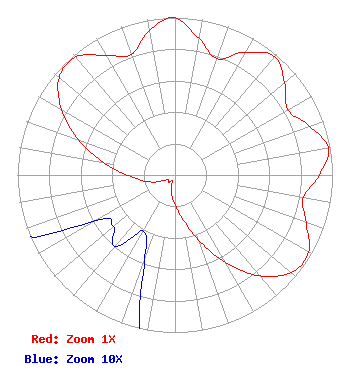 | ||||||||||||||||||
| Azimuth | Ratio | Azimuth | Ratio | Azimuth | Ratio | Azimuth | Ratio | ||||||||||||
| 0 | 0.998 | 10 | 0.878 | 20 | 0.786 | 30 | 0.900 | ||||||||||||
| 40 | 0.981 | 50 | 0.909 | 60 | 0.827 | 70 | 0.908 | ||||||||||||
| 80 | 0.988 | 90 | 0.917 | 100 | 0.827 | 110 | 0.886 | ||||||||||||
| 120 | 0.980 | 130 | 0.963 | 140 | 0.834 | 150 | 0.641 | ||||||||||||
| 160 | 0.440 | 170 | 0.284 | 180 | 0.188 | 190 | 0.123 | ||||||||||||
| 200 | 0.056 | 210 | 0.041 | 220 | 0.059 | 230 | 0.051 | ||||||||||||
| 240 | 0.058 | 250 | 0.130 | 260 | 0.209 | 270 | 0.302 | ||||||||||||
| 280 | 0.462 | 290 | 0.650 | 300 | 0.831 | 310 | 0.961 | ||||||||||||
| 320 | 0.979 | 330 | 0.876 | 340 | 0.811 | 350 | 0.931 | ||||||||||||
| 358 | 1.000 | 359 | 1.000 | ||||||||||||||||
Structure Registration Number 1059622 Structure Type: GTOWER Registered To: American Towers LLC Structure Address: 2945 Senior Rd (30285 / Missouri City) Missouri City, TX County Name: Fort Bend County ASR Issued: 11/16/2022 Date Built: 08/30/2000 Site Elevation: 22.6 m (74 ft.) Structure Height: 562.1 m (1844 ft.) Height Overall: 601.7 m (1974 ft.) Overall Height AMSL: 624.3 m (2048 ft.) FAA Determination: 11/08/2022 FAA Study #: 2021-ASW-19989-OE FAA Circular #: 70/7460-1K Paint & Light FAA Chapters: 4, 7, 12 OM&L to remain the same as prior study = 24-HR HI-STROBES 29-33-45.2 N 95-30-35.9 W (NAD 83) 29-33-44.4 N 95-30-35.1 W (Converted to NAD 27) |
Tegna Inc. 8350 Broad Street, Suite 2000 Tysons, VA 22102 Phone: 703-873-6606 Corporation | Title: Secretary Date: 05/01/2019 Application Certifier KTBU LICENSING, INC. Ktbu Licensing, Inc. 7007 Nw 77th Ave. Miami, FL 33166 Applicant Carl Gluck Carl T. Jones Corp Carl T Jones Corp 7901 Yarnwood Court Springfield, VA 22153 Consultant Pierre Jaspar Spanish Broadcasting System, Inc. 7007 Nw 77th Avenue Miami, FL 33166 VP OF ENGINEERING Nancy A Ory, Esq Lerman Senter Pllc 2001 L St Nw Suite 400 Washington, DC 20036 | |||||||||||||||||