
FCCInfo.com
A Service of Cavell, Mertz & Associates, Inc.
(855) FCC-INFO
|
|
W27EF-D from 06/19/2003 W27EF-D from 12/08/1994 |
|
|
||||||||||||||||
|
|
Status: STA – Special Temporary Authority Application Accepted: 05/03/2019 STA Expires: 05/06/2019 File Number: -0000072337 FCC Website Links: LMS Facility Details This Application Other W27EF-D Applications Including Superseded Applications Mailing Address Correspondence for W27EF-D Correspondence related to application -0000072337 Service Contour - Open Street Map or USGS Map (74 dBu) Service Contour - KML / Google Earth (74 dBu) Rabbit Ears Info Search for W27EF-D Site Location: 38-22-31.0 N 81-39-20.0 W (NAD 83) Site Location: 38-22-30.7 N 81-39-20.6 W (Converted to NAD 27) ERP: 22.9 kW R/C AGL: 50 m (164 ft.) R/C AMSL: 357.9 m (1174 ft.) Site Elevation: 307.9 m. (1010 ft.) Height Overall*: 59.4 m (195 ft.) (* As Filed In This Application, may differ from ASR Data, Below.) Directional Antenna - Antenna Make/Model: Andrew ALP16L4-HSBR Antenna ID: 16553
| ||||||||||||||||||
| Antenna Data for Antenna Id: 16553 W27EF-D TX File: -0000072337 Andrew - ALP16L4-HSBR Service: TX Standard Pattern: Y | 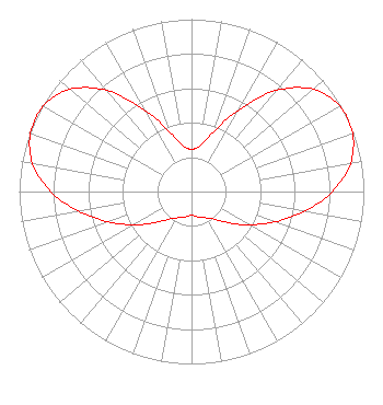 | ||||||||||||||||||
| Azimuth | Ratio | Azimuth | Ratio | Azimuth | Ratio | Azimuth | Ratio | ||||||||||||
| 0 | 0.246 | 10 | 0.269 | 20 | 0.364 | 30 | 0.549 | ||||||||||||
| 40 | 0.765 | 50 | 0.923 | 60 | 0.992 | 70 | 0.994 | ||||||||||||
| 80 | 0.936 | 90 | 0.818 | 100 | 0.664 | 110 | 0.513 | ||||||||||||
| 120 | 0.386 | 130 | 0.282 | 140 | 0.211 | 150 | 0.177 | ||||||||||||
| 160 | 0.161 | 170 | 0.146 | 180 | 0.137 | 190 | 0.146 | ||||||||||||
| 200 | 0.161 | 210 | 0.177 | 220 | 0.211 | 230 | 0.282 | ||||||||||||
| 240 | 0.386 | 250 | 0.513 | 260 | 0.664 | 270 | 0.818 | ||||||||||||
| 280 | 0.936 | 290 | 0.994 | 300 | 0.992 | 310 | 0.923 | ||||||||||||
| 320 | 0.765 | 330 | 0.549 | 340 | 0.364 | 350 | 0.269 | ||||||||||||
Structure Registration Number 1061555 Structure Type: TOWER Registered To: Gray Media Group, Inc. Structure Address: End Of Garfield Street Charleston, WV County Name: Kanawha County ASR Issued: 09/09/2020 Date Built: 03/01/1993 Site Elevation: 307.9 m (1010 ft.) Structure Height: 55.3 m (181 ft.) Height Overall: 59.4 m (195 ft.) Overall Height AMSL: 367.3 m (1205 ft.) FAA Determination: 05/27/1998 FAA Study #: 98-AEA-0941-OE Paint & Light FAA Chapters: None 38-22-31.0 N 81-39-20.0 W (NAD 83) 38-22-30.7 N 81-39-20.6 W (Converted to NAD 27) |
645 Fifth Avenue Huntington, WV 25701 Phone: 304-697-4780 Limited Liability Company | Title: Assistant Secretary Date: 05/03/2019 Application Certifier Gray Television Licensee, Llc 645 Fifth Avenue Huntington, WV 25701 Applicant Joseph M. Davis, P.E. Chesapeake Rf Consultants, Llc 207 Old Dominion Road Yorktown, VA 23692 Consulting Engineer JOAN STEWART Wiley Rein Llp 1776 K Street, Nw Washington, DC 20006 | |||||||||||||||||