
FCCInfo.com
A Service of Cavell, Mertz & Associates, Inc.
(855) FCC-INFO
|
|
K17DL-D from 03/03/1993 |
|
|
|||||||||||||||||||
|
|
Status: License Application Accepted: 05/16/2019 License Expires: 02/01/2022 File Number: -0000072816 FCC Website Links: LMS Facility Details This Application Other K17DL-D Applications Including Superseded Applications Mailing Address Correspondence for K17DL-D Correspondence related to application -0000072816 Service Contour - Open Street Map or USGS Map (51 dBu) Service Contour - KML / Google Earth (51 dBu) Rabbit Ears Info Search for K17DL-D Site Location: 36-44-53.5 N 93-16-38.0 W (NAD 83) Site Location: 36-44-53.3 N 93-16-37.3 W (Converted to NAD 27) ERP: 2.1 kW Polarization: Circularly polarized R/C AGL: 145 m (476 ft.) R/C AMSL: 556 m (1824 ft.) Emission Mask: Full Service Site Elevation: 411 m. (1348 ft.) Height Overall*: 152 m (499 ft.) (* As Filed In This Application, may differ from ASR Data, Below.) Directional Antenna - Antenna Make/Model: Systems With Reliability Inc. SWMP16EC/17CP Antenna ID: 89740 Polarization: Circularly polarized | |||||||||||||||||||||
| Antenna Data for Antenna Id: 89740 K17DL-D LD File: -0000072816 Systems With Reliability Inc. - SWMP16EC/17CP Service: LD Standard Pattern: Y Pattern and Field Values Include a 140° Clockwise Rotation | 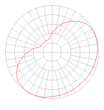 | |||||||||||||||||||||
| Azimuth | Ratio | Azimuth | Ratio | Azimuth | Ratio | Azimuth | Ratio | |||||||||||||||
| 0 | 0.400 | 10 | 0.510 | 20 | 0.640 | 30 | 0.750 | |||||||||||||||
| 40 | 0.850 | 50 | 0.940 | 60 | 0.980 | 70 | 0.990 | |||||||||||||||
| 80 | 0.980 | 90 | 0.970 | 100 | 0.950 | 110 | 0.940 | |||||||||||||||
| 120 | 0.930 | 130 | 0.920 | 140 | 0.910 | 150 | 0.920 | |||||||||||||||
| 160 | 0.930 | 170 | 0.940 | 180 | 0.950 | 190 | 0.980 | |||||||||||||||
| 200 | 0.990 | 210 | 1.000 | 220 | 0.980 | 230 | 0.950 | |||||||||||||||
| 240 | 0.870 | 250 | 0.770 | 260 | 0.640 | 270 | 0.510 | |||||||||||||||
| 280 | 0.400 | 290 | 0.300 | 300 | 0.270 | 310 | 0.270 | |||||||||||||||
| 320 | 0.270 | 330 | 0.270 | 340 | 0.270 | 350 | 0.300 | |||||||||||||||
Structure Registration Number 1060435 Structure Type: TOWER Registered To: Branson Visitors TV, LLC Structure Address: 0.5 Km Ne Of Us Rte. 160 And Sr 248 Irma, MO County Name: Taney County ASR Issued: 09/01/2010 Date Built: 09/10/2010 Site Elevation: 411 m (1348 ft.) Structure Height: 152 m (499 ft.) Height Overall: 152 m (499 ft.) Overall Height AMSL: 563 m (1847 ft.) FAA Determination: 08/25/2010 FAA Study #: 2010-ACE-1979-OE FAA Circular #: 70/7460-1K Paint & Light FAA Chapters: 4, 6, 12 PRIOR STUDY 1998-ACE-1506-OE 36-44-53.5 N 93-16-38.0 W (NAD 83) 36-44-53.3 N 93-16-37.3 W (Converted to NAD 27) |
P.o. Box 3500 Springfield, MO 65808 Phone: 417-268-3010 Limited Liability Company | Title: Authorized Signatory Date: 05/16/2019 Application Certifier Branson Visitors Tv, Llc P.o. Box 3500 Springfield, MO 65808 Applicant Joseph M. Davis, P.E. Chesapeake Rf Consultants, Llc 207 Old Dominion Road Yorktown, VA 23692 Consulting Engineer Joan Stewart Wiley Rein Llp 1776 K Street, Nw Washington, DC 20006 | ||||||||||||||||||||
| ||||||||||||||||||||||