
FCCInfo.com
A Service of Cavell, Mertz & Associates, Inc.
(855) FCC-INFO
|
|
|
Virtual Channel 21 |  |
|
|||||||||||||||
|
|
Repacking Information: No changes Status: License Application Accepted: 07/16/2019 License Expires: 12/01/2021 File Number: -0000078129 FCC Website Links: LMS Facility Details This Application Other WHA-TV Applications Including Superseded Applications Mailing Address Correspondence for WHA-TV Correspondence related to application -0000078129 Service Contour - Open Street Map or USGS Map (41 dBu) Service Contour - KML / Google Earth (41 dBu) Public Inspection Files History Cards for WHA-TV Rabbit Ears Info Search for WHA-TV Site Location: 43-03-21.0 N 89-32-06.0 W (NAD 83) Site Location: 43-03-21.0 N 89-32-05.6 W (Converted to NAD 27) ERP: 200 kW Polarization: Horizontally polarized HAAT: 408 m (1339 ft.) Electrical Beam Tilt: 0.75 degrees R/C AGL: 365.2 m (1198 ft.) R/C AMSL: 708.4 m (2324 ft.) Site Elevation: 343.2 m. (1126 ft.) Height Overall*: 433.7 m (1423 ft.) (* As Filed In This Application, may differ from ASR Data, Below.) Directional Antenna - Antenna Make/Model: DIELECTRIC TUP-C3-8-1 Antenna ID: 43177 Polarization: Horizontally polarized | ||||||||||||||||||
| Antenna Data for Antenna Id: 43177 WHA-TV DX File: -0000078129 DIELECTRIC - TUP-C3-8-1 Service: DX Standard Pattern: Y Pattern and Field Values Include a 90° Clockwise Rotation | 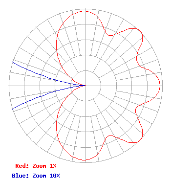 | ||||||||||||||||||
| Azimuth | Ratio | Azimuth | Ratio | Azimuth | Ratio | Azimuth | Ratio | ||||||||||||
| 0 | 0.966 | 10 | 0.907 | 20 | 0.751 | 25 | 0.720 | ||||||||||||
| 30 | 0.770 | 40 | 0.964 | 45 | 1.000 | 50 | 0.964 | ||||||||||||
| 60 | 0.770 | 70 | 0.751 | 80 | 0.907 | 90 | 0.966 | ||||||||||||
| 100 | 0.907 | 110 | 0.751 | 115 | 0.720 | 120 | 0.770 | ||||||||||||
| 130 | 0.964 | 135 | 1.000 | 140 | 0.964 | 150 | 0.770 | ||||||||||||
| 155 | 0.720 | 160 | 0.751 | 170 | 0.907 | 180 | 0.966 | ||||||||||||
| 190 | 0.938 | 200 | 0.858 | 210 | 0.735 | 220 | 0.582 | ||||||||||||
| 230 | 0.417 | 240 | 0.259 | 250 | 0.126 | 260 | 0.035 | ||||||||||||
| 270 | 0.001 | 280 | 0.035 | 290 | 0.126 | 300 | 0.259 | ||||||||||||
| 310 | 0.417 | 320 | 0.582 | 330 | 0.735 | 340 | 0.858 | ||||||||||||
| 350 | 0.938 | ||||||||||||||||||
Structure Registration Number 1033919 Structure Type: GTOWER Registered To: UNIVERSITY OF WISCONSIN MADISON (DBA MADISON CANDELABRA TOWER) Structure Address: 451 S. Pleasant View Road Verona, WI County Name: Dane County ASR Issued: 05/22/2018 Date Built: 01/01/2019 Site Elevation: 343.2 m (1126 ft.) Structure Height: 402.2 m (1320 ft.) Height Overall: 433.7 m (1423 ft.) Overall Height AMSL: 776.9 m (2549 ft.) FAA Determination: 05/02/2018 FAA Study #: 2018-AGL-8179-OE FAA Circular #: 70/7460-1L Paint & Light FAA Chapters: 4, 9, 12 PRIOR STUDY 2009-AGL-2049-OE 43-03-21.0 N 89-32-06.0 W (NAD 83) 43-03-21.0 N 89-32-05.6 W (Converted to NAD 27) |
1860 Van Hise Hall 1220 Linden Drive Madison, WI 53706 Phone: 608-262-2324 Government Entity | Title: Executive Director And Corporate Secretary Date: 07/16/2019 Application Certifier BOARD OF REGENTS OF THE UNIVERSITY OF WISCONSIN SYSTEM Board Of Regents Of The University Of Wisconsin System 1860 Van Hise Hall 1220 Linden Drive Madison, WI 53706 Applicant Derek Teslik Gray Miller Persh Llp 2233 Wisconsin Ave Nw Ste 226 Washington, DC 20007-4119 | |||||||||||||||||
|
| ||||||||||||||||||