
FCCInfo.com
A Service of Cavell, Mertz & Associates, Inc.
(855) FCC-INFO
|
|
W26FA-D from 06/16/2009 |
|
|
|||||||||||||||||
|
|
Status: License Application Accepted: 06/24/2019 License Expires: 12/01/2020 File Number: -0000074929 FCC Website Links: LMS Facility Details This Application Other W26FA-D Applications Including Superseded Applications Mailing Address Correspondence for W26FA-D Correspondence related to application -0000074929 Service Contour - Open Street Map or USGS Map (51 dBu) Service Contour - KML / Google Earth (51 dBu) Rabbit Ears Info Search for W26FA-D Site Location: 35-42-33.0 N 81-31-31.9 W (NAD 83) Site Location: 35-42-32.5 N 81-31-32.6 W (Converted to NAD 27) ERP: 14 kW Polarization: Horizontally polarized Electrical Beam Tilt: 1.25 degrees R/C AGL: 84 m (276 ft.) R/C AMSL: 725 m (2379 ft.) Emission Mask: Full Service Site Elevation: 641 m. (2103 ft.) Height Overall*: 106.1 m (348 ft.) (* As Filed In This Application, may differ from ASR Data, Below.) Directional Antenna - Antenna Make/Model: Electronics Research Inc. ALP12L5-HSNR-26 Antenna ID: 1003649 Polarization: Horizontally polarized
| |||||||||||||||||||
| Antenna Data for Antenna Id: 1003649 W26FA-D LD File: -0000074929 Electronics Research Inc. - ALP12L5-HSNR-26 Service: LD Standard Pattern: N Pattern and Field Values Include a 257° Clockwise Rotation | 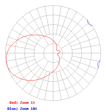 | |||||||||||||||||||
| Azimuth | Ratio | Azimuth | Ratio | Azimuth | Ratio | Azimuth | Ratio | |||||||||||||
| 7 | 0.237 | 17 | 0.205 | 27 | 0.172 | 37 | 0.130 | |||||||||||||
| 47 | 0.099 | 57 | 0.103 | 67 | 0.133 | 77 | 0.151 | |||||||||||||
| 87 | 0.133 | 97 | 0.103 | 107 | 0.099 | 117 | 0.130 | |||||||||||||
| 127 | 0.172 | 137 | 0.205 | 147 | 0.237 | 157 | 0.276 | |||||||||||||
| 167 | 0.323 | 177 | 0.375 | 187 | 0.438 | 197 | 0.520 | |||||||||||||
| 207 | 0.617 | 217 | 0.721 | 227 | 0.822 | 237 | 0.912 | |||||||||||||
| 247 | 0.976 | 257 | 1.000 | 267 | 0.976 | 277 | 0.912 | |||||||||||||
| 287 | 0.822 | 297 | 0.721 | 307 | 0.617 | 317 | 0.520 | |||||||||||||
| 327 | 0.438 | 337 | 0.375 | 347 | 0.323 | 357 | 0.276 | |||||||||||||
Structure Registration Number 1008484 Structure Type: TOWER Registered To: Pinnacle Towers LLC Structure Address: End Of Coldwater St Valdese, NC County Name: Burke County ASR Issued: 05/06/2016 Date Built: 02/01/1985 Site Elevation: 641 m (2103 ft.) Structure Height: 103.6 m (340 ft.) Height Overall: 106.1 m (348 ft.) Overall Height AMSL: 747.1 m (2451 ft.) FAA Determination: 12/16/2009 FAA Study #: 2009-ASO-6342-OE FAA Circular #: 70/7460-1K Paint & Light FAA Chapters: 4, 6, 12 PRIOR STUDY 2009-ASO-3519-OE 35-42-33.0 N 81-31-31.9 W (NAD 83) 35-42-32.5 N 81-31-32.6 W (Converted to NAD 27) |
1601 W. Peachtree Street, Ne Atlanta, GA 30309 Phone: 404-897-7000 Limited Liability Company | Title: Vice President And General Manager Date: 06/24/2019 Application Certifier WSOC TELEVISION, LLC Wsoc Television, Llc P.o. Box 34665 Charlotte, NC 28234 Applicant Christina H Burrow Cooley Llp 1299 Pennsylvania Avenue, Nw Suite 700 Washington, DC 20004 Legal Counsel Ted Hand Wsoc Television, Llc P.o. Box 34665 Charlotte, NC 28234 Chief Engineer S Merrill Weiss Merrill Weiss Group Llc 227 Central Avenue Metuchen, NJ 08840 President | ||||||||||||||||||