
FCCInfo.com
A Service of Cavell, Mertz & Associates, Inc.
(855) FCC-INFO
|
|
KDTX-TV from 01/15/1985 |
Post-repack Channel 21 Virtual Channel 58 |
|
||||||||||||||||
|
|
Repacking Information: Pre-Repack Channel: 45 Post-Repack Channel: 21 Post-Repack ERP: 611 kW Phase: 3 Completion Deadline: 6/21/2019 Find nearby TV Facilities Status: License Application Accepted: 07/01/2019 License Expires: 08/01/2022 File Number: -0000075181 FCC Website Links: LMS Facility Details This Application Other KDTX-TV Applications Including Superseded Applications Mailing Address Correspondence for KDTX-TV Correspondence related to application -0000075181 Service Contour - Open Street Map or USGS Map (41 dBu) Service Contour - KML / Google Earth (41 dBu) Public Inspection Files Rabbit Ears Info Search for KDTX-TV Site Location: 32-35-22.0 N 96-58-12.9 W (NAD 83) Site Location: 32-35-21.5 N 96-58-11.9 W (Converted to NAD 27) ERP: 735 kW Polarization: Horizontally polarized HAAT: 494 m (1621 ft.) Electrical Beam Tilt: 0.7 degrees R/C AGL: 462.7 m (1518 ft.) R/C AMSL: 715.6 m (2348 ft.) Site Elevation: 252.9 m. (830 ft.) Height Overall*: 487.7 m (1600 ft.) (* As Filed In This Application, may differ from ASR Data, Below.) Directional Antenna - Antenna Make/Model: Dielectric TUM-AP-C4-14/48H-2-R-B Antenna ID: 1005180 Polarization: Horizontally polarized | ||||||||||||||||||
| Antenna Data for Antenna Id: 1005180 KDTX-TV DT File: -0000075181 Dielectric - TUM-AP-C4-14/48H-2-R-B Service: DT Standard Pattern: N | 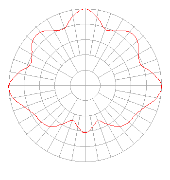 | ||||||||||||||||||
| Azimuth | Ratio | Azimuth | Ratio | Azimuth | Ratio | Azimuth | Ratio | ||||||||||||
| 0 | 0.993 | 10 | 0.900 | 20 | 0.777 | 30 | 0.818 | ||||||||||||
| 40 | 0.905 | 50 | 0.895 | 60 | 0.805 | 70 | 0.777 | ||||||||||||
| 80 | 0.897 | 90 | 0.997 | 100 | 0.952 | 110 | 0.834 | ||||||||||||
| 120 | 0.767 | 130 | 0.750 | 140 | 0.704 | 150 | 0.590 | ||||||||||||
| 160 | 0.494 | 170 | 0.558 | 180 | 0.622 | 190 | 0.550 | ||||||||||||
| 200 | 0.487 | 210 | 0.590 | 220 | 0.705 | 230 | 0.747 | ||||||||||||
| 240 | 0.766 | 250 | 0.838 | 260 | 0.957 | 268 | 1.000 | ||||||||||||
| 270 | 0.995 | 280 | 0.888 | 290 | 0.767 | 300 | 0.801 | ||||||||||||
| 310 | 0.894 | 320 | 0.903 | 330 | 0.819 | 340 | 0.787 | ||||||||||||
| 350 | 0.910 | ||||||||||||||||||
Structure Registration Number 1055009 Structure Type: GTOWER Registered To: American Towers LLC Structure Address: 1360 W. Belt Line Rd. (075253) Cedar Hill, TX County Name: Dallas County ASR Issued: 12/19/2017 Date Built: 11/04/2008 Site Elevation: 252.9 m (830 ft.) Structure Height: 442.9 m (1453 ft.) Height Overall: 487.7 m (1600 ft.) Overall Height AMSL: 740.6 m (2430 ft.) FAA Determination: 12/13/2017 FAA Study #: 2017-ASW-18744-OE Paint & Light FAA Chapters: 1, 3, 10.1, 19.1, 21 PRIOR STUDY 2012-ASW-2206-OE 32-35-22.0 N 96-58-12.9 W (NAD 83) 32-35-21.5 N 96-58-11.9 W (Converted to NAD 27) |
13600 Heritage Parkway Suite 200 Fort Worth, TX 76177 Phone: 855-826-2255 Not-for-Profit | Title: Assistant Secretary Date: 07/01/2019 Application Certifier Trinity Broadcasting Network Trinity Broadcasting Of Texas, Inc. 13600 Heritage Parkway Fort Worth, TX 76177 Applicant Kevin T. Fisher Smith & Fisher 4791 Wintergreen Court Woodbridge, VA 22192 Broadcast Consultant Coby M May, Esq. Colby M. May, Esq., P.c. P. O. Box 15473 Washington, DC 20003 Attorney | |||||||||||||||||
|
| ||||||||||||||||||