
FCCInfo.com
A Service of Cavell, Mertz & Associates, Inc.
(855) FCC-INFO
|
|
K33OQ-D from 01/12/2007 |
|
|
||||||||||||||||
|
|
Status: License Application Accepted: 07/05/2019 License Expires: 10/03/2022 File Number: -0000075947 FCC Website Links: LMS Facility Details This Application Other K33OQ-D Applications Including Superseded Applications Mailing Address Correspondence for K33OQ-D Correspondence related to application -0000075947 Service Contour - Open Street Map or USGS Map (51 dBu) Service Contour - KML / Google Earth (51 dBu) Rabbit Ears Info Search for K33OQ-D Site Location: 37-47-10.5 N 111-35-39.9 W (NAD 83) Site Location: 37-47-10.5 N 111-35-37.3 W (Converted to NAD 27) ERP: 0.09 kW Polarization: Horizontally polarized R/C AGL: 15 m (49 ft.) R/C AMSL: 1834.6 m (6019 ft.) Emission Mask: Simple Site Elevation: 1819.6 m. (5970 ft.) Height Overall*: 18.3 m (60 ft.) (* As Filed In This Application, may differ from ASR Data, Below.) Directional Antenna - Antenna Make/Model: Kathrein K72314 Antenna ID: 19753 Polarization: Horizontally polarized
| ||||||||||||||||||
| Antenna Data for Antenna Id: 19753 K33OQ-D LD File: -0000075947 Kathrein - K72314 Service: LD Standard Pattern: Y Pattern and Field Values Include a 200° Clockwise Rotation | 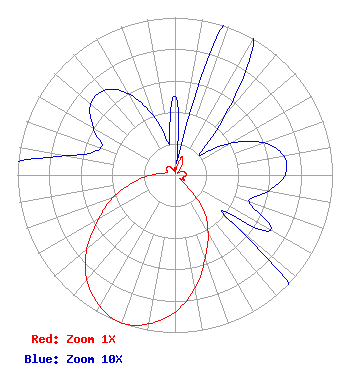 | ||||||||||||||||||
| Azimuth | Ratio | Azimuth | Ratio | Azimuth | Ratio | Azimuth | Ratio | ||||||||||||
| 0 | 0.050 | 10 | 0.010 | 20 | 0.120 | 30 | 0.100 | ||||||||||||
| 40 | 0.050 | 50 | 0.020 | 60 | 0.040 | 70 | 0.060 | ||||||||||||
| 80 | 0.070 | 90 | 0.070 | 100 | 0.060 | 110 | 0.050 | ||||||||||||
| 120 | 0.070 | 130 | 0.050 | 140 | 0.270 | 150 | 0.420 | ||||||||||||
| 160 | 0.560 | 170 | 0.730 | 180 | 0.870 | 190 | 0.960 | ||||||||||||
| 200 | 1.000 | 210 | 0.960 | 220 | 0.870 | 230 | 0.730 | ||||||||||||
| 240 | 0.560 | 250 | 0.420 | 260 | 0.270 | 270 | 0.150 | ||||||||||||
| 280 | 0.070 | 290 | 0.050 | 300 | 0.060 | 310 | 0.070 | ||||||||||||
| 320 | 0.070 | 330 | 0.060 | 340 | 0.040 | 350 | 0.020 | ||||||||||||
Structure Registration Number 1272620 Structure Type: TOWER Registered To: Garfield County Structure Address: 2.2 Miles Northwest Of Escalante, Ut Escalante, UT County Name: Garfield County ASR Issued: 01/15/2010 Date Built: 07/20/2009 Site Elevation: 1819.6 m (5970 ft.) Structure Height: 18.3 m (60 ft.) Height Overall: 18.3 m (60 ft.) Overall Height AMSL: 1837.9 m (6030 ft.) FAA Determination: 08/27/2009 FAA Study #: 2009-ANM-1382-OE Paint & Light FAA Chapters: NONE 37-47-10.5 N 111-35-39.9 W (NAD 83) 37-47-10.5 N 111-35-37.3 W (Converted to NAD 27) |
55 South Main Courthouse Building Panguitch, UT 84759 Phone: 435-676-1120 Government Entity | Title: Technical Representative Date: 07/05/2019 Application Certifier GARFIELD COUNTY Garfield County 55 South Main Courthouse Building Panguitch, UT 84759 Applicant Camille Moore Garfield County 55 South Main Street Courthouse Building Panguitch, UT 84759 Auditor/Clerk MAURI KENT PARSONS Garfield County 371 South 460 East Monroe, UT 84754 Technical Representative | |||||||||||||||||