
FCCInfo.com
A Service of Cavell, Mertz & Associates, Inc.
(855) FCC-INFO
|
|
WSKC-CD from 10/19/2005 WSKC-CD from 02/01/1995 WSKC-CD from 04/04/1996 WSKC-CD from 09/28/1995 WSKC-CD from 09/24/1984 |
Post-repack Channel 14 |  |
|
|||||||||||||||
|
|
Repacking Information: Pre-Repack Channel: 22 Post-Repack Channel: 14 Post-Repack ERP: 12.3 kW Phase: 5 Completion Deadline: 9/11/2019 Upstream/Downstream Dependencies Other Linked Stations Find nearby TV Facilities Status: License Application Accepted: 09/06/2019 License Expires: 04/01/2021 File Number: -0000080978 FCC Website Links: LMS Facility Details This Application Other WSKC-CD Applications Including Superseded Applications Mailing Address Correspondence for WSKC-CD Correspondence related to application -0000080978 Service Contour - Open Street Map or USGS Map (51 dBu) Service Contour - KML / Google Earth (51 dBu) Public Inspection Files Rabbit Ears Info Search for WSKC-CD Site Location: 33-58-38.3 N 84-09-23.3 W (NAD 83) Site Location: 33-58-37.9 N 84-09-23.6 W (Converted to NAD 27) ERP: 15 kW Polarization: Elliptically polarized R/C AGL: 80.4 m (264 ft.) R/C AMSL: 404.7 m (1328 ft.) Emission Mask: Stringent Site Elevation: 324.3 m. (1064 ft.) Height Overall*: 88.7 m (291 ft.) (* As Filed In This Application, may differ from ASR Data, Below.) Directional Antenna - Antenna Make/Model: Propagation System Inc PSIL8CUS-14-CP Antenna ID: 1005505 Polarization: Elliptically polarized | ||||||||||||||||||
| Antenna Data for Antenna Id: 1005505 WSKC-CD DC File: -0000080978 Propagation System Inc - PSIL8CUS-14-CP Service: DC Standard Pattern: N Pattern and Field Values Include a 240° Clockwise Rotation | 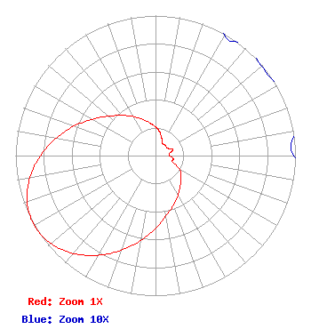 | ||||||||||||||||||
| Azimuth | Ratio | Azimuth | Ratio | Azimuth | Ratio | Azimuth | Ratio | ||||||||||||
| 0 | 0.205 | 10 | 0.172 | 20 | 0.130 | 30 | 0.099 | ||||||||||||
| 40 | 0.103 | 50 | 0.099 | 60 | 0.103 | 70 | 0.133 | ||||||||||||
| 80 | 0.103 | 90 | 0.099 | 100 | 0.130 | 110 | 0.130 | ||||||||||||
| 120 | 0.205 | 130 | 0.237 | 140 | 0.276 | 150 | 0.323 | ||||||||||||
| 160 | 0.375 | 170 | 0.438 | 180 | 0.520 | 190 | 0.617 | ||||||||||||
| 200 | 0.721 | 210 | 0.822 | 220 | 0.912 | 230 | 0.976 | ||||||||||||
| 240 | 1.000 | 250 | 0.976 | 260 | 0.912 | 270 | 0.822 | ||||||||||||
| 280 | 0.721 | 290 | 0.617 | 300 | 0.520 | 310 | 0.438 | ||||||||||||
| 320 | 0.375 | 330 | 0.323 | 340 | 0.276 | 350 | 0.237 | ||||||||||||
Structure Registration Number 1020086 Structure Type: LTOWER Registered To: Crown Castle South LLC Structure Address: 2963 Pleasant Hill Rd Duluth, GA County Name: Gwinnett County ASR Issued: 05/06/2016 Date Built: 11/23/1988 Site Elevation: 324.3 m (1064 ft.) Structure Height: 86.3 m (283 ft.) Height Overall: 88.7 m (291 ft.) Overall Height AMSL: 413 m (1355 ft.) FAA Determination: 05/18/2010 FAA Study #: 2010-ASO-2010-OE Paint & Light FAA Chapters: A1, H PRIOR STUDY 2009-ASO-2555-OE 33-58-38.3 N 84-09-23.3 W (NAD 83) 33-58-37.9 N 84-09-23.6 W (Converted to NAD 27) |
3654 West Jarvis Avenue Skokie, IL 60076 Phone: 847-674-0864 Limited Liability Company | Title: President Date: 09/06/2019 Application Certifier KM LPTV OF ATLANTA, L.L.C. Km Lptv Of Atlanta, L.l.c. 3654 West Jarvis Avenue Skokie, IL 60076 Applicant Sid Khanna Smith Khanna And Guill, Inc. 1203 Woodlea Mill Court Mclean, VA 22102 Consulting Engineer Jeffrey L. Timmons, Esq. Jeffrey L. Timmons, Esq. 974 Branford Lane Nw Lilburn, GA 30047 FCC Counsel | |||||||||||||||||