
FCCInfo.com
A Service of Cavell, Mertz & Associates, Inc.
(855) FCC-INFO
|
|
|
Post-repack Channel 28 Virtual Channel 24 |  |
|
|||||||||||||||
|
|
Repacking Information: Pre-Repack Channel: 24 Post-Repack Channel: 28 Post-Repack ERP: 571 kW Phase: 4 Completion Deadline: 8/2/2019 Upstream/Downstream Dependencies Other Linked Stations Find nearby TV Facilities Status: License Application Accepted: 08/28/2019 License Expires: 08/01/2023 File Number: -0000080704 FCC Website Links: LMS Facility Details This Application Other WJET-TV Applications Including Superseded Applications Mailing Address Correspondence for WJET-TV Correspondence related to application -0000080704 Service Contour - Open Street Map or USGS Map (41 dBu) Service Contour - KML / Google Earth (41 dBu) Public Inspection Files History Cards for WJET-TV Rabbit Ears Info Search for WJET-TV Site Location: 42-02-25.0 N 80-04-08.0 W (NAD 83) Site Location: 42-02-24.8 N 80-04-08.8 W (Converted to NAD 27) ERP: 650 kW Polarization: Elliptically polarized HAAT: 304.9 m (1000 ft.) Electrical Beam Tilt: 1.0 degree R/C AGL: 238.3 m (782 ft.) R/C AMSL: 636.1 m (2087 ft.) Site Elevation: 397.8 m. (1305 ft.) Height Overall*: 248.9 m (817 ft.) (* As Filed In This Application, may differ from ASR Data, Below.) Directional Antenna - Antenna Make/Model: Dielectric TFU-29JTH/VP-R C170 Antenna ID: 1005474 Polarization: Elliptically polarized | ||||||||||||||||||
| Antenna Data for Antenna Id: 1005474 WJET-TV DT File: -0000080704 Dielectric - TFU-29JTH/VP-R C170 Service: DT Standard Pattern: N | 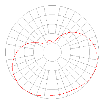 | ||||||||||||||||||
| Azimuth | Ratio | Azimuth | Ratio | Azimuth | Ratio | Azimuth | Ratio | ||||||||||||
| 0 | 0.220 | 5 | 0.210 | 10 | 0.220 | 20 | 0.290 | ||||||||||||
| 30 | 0.410 | 40 | 0.540 | 50 | 0.650 | 60 | 0.750 | ||||||||||||
| 70 | 0.830 | 80 | 0.900 | 90 | 0.950 | 100 | 0.980 | ||||||||||||
| 110 | 1.000 | 120 | 0.990 | 130 | 0.980 | 140 | 0.950 | ||||||||||||
| 150 | 0.930 | 160 | 0.920 | 170 | 0.920 | 180 | 0.930 | ||||||||||||
| 190 | 0.950 | 200 | 0.980 | 210 | 0.990 | 220 | 1.000 | ||||||||||||
| 230 | 0.980 | 240 | 0.950 | 250 | 0.900 | 260 | 0.830 | ||||||||||||
| 270 | 0.750 | 280 | 0.650 | 290 | 0.540 | 300 | 0.410 | ||||||||||||
| 310 | 0.290 | 320 | 0.220 | 325 | 0.210 | 330 | 0.220 | ||||||||||||
| 340 | 0.250 | 350 | 0.250 | ||||||||||||||||
Structure Registration Number 1033280 Structure Type: TOWER Registered To: Nexstar Media Inc. Structure Address: 8455 Peach St Erie, PA County Name: Erie County ASR Issued: 05/28/2021 Date Built: 01/01/1997 Site Elevation: 397.8 m (1305 ft.) Structure Height: 228.9 m (751 ft.) Height Overall: 248.9 m (817 ft.) Overall Height AMSL: 646.7 m (2122 ft.) FAA Determination: 09/19/1997 FAA Study #: 97-AEA-2333-OE FAA Circular #: 70/7460-1J Paint & Light FAA Chapters: 3, 4, 5, 13 42-02-25.0 N 80-04-08.0 W (NAD 83) 42-02-24.8 N 80-04-08.8 W (Converted to NAD 27) |
545 E. John Carpenter Freeway Suite 700 Irving, TX 75062 Phone: 214-765-4229 Corporation | Title: General Counsel Date: 08/28/2019 Application Certifier Nexstar Broadcasting, Inc. 545 E. John Carpenter Freeway Suite 700 Irving, TX 75062 Applicant William T. Godfrey, Jr Kessler And Gehman Associates, Inc. Kessler And Gehman Associates, Inc. 507-d Nw 60th Street Gainesville, FL 32607 Consulting Engineers Elizabeth Ryder Nexstar Broadcasting, Inc. 545 E John Carpenter Freeway Suite 700 Irving, TX 75062 General Counsel | |||||||||||||||||
|
| ||||||||||||||||||