
FCCInfo.com
A Service of Cavell, Mertz & Associates, Inc.
(855) FCC-INFO
|
|
W35DK-D from 08/25/2015 W36AZ from 01/04/1989 |
|
|
||||||||||||||||
|
|
Status: License Application Accepted: 08/08/2019 License Expires: 06/01/2023 File Number: -0000080129 FCC Website Links: LMS Facility Details This Application Other W23EX-D Applications Including Superseded Applications Mailing Address Correspondence for W23EX-D Correspondence related to application -0000080129 Service Contour - Open Street Map or USGS Map (51 dBu) Service Contour - KML / Google Earth (51 dBu) Rabbit Ears Info Search for W23EX-D Site Location: 41-08-37.0 N 74-32-17.0 W (NAD 83) Site Location: 41-08-36.7 N 74-32-18.4 W (Converted to NAD 27) ERP: 3.87 kW Polarization: Horizontally polarized Electrical Beam Tilt: 1.75 degrees R/C AGL: 52 m (171 ft.) R/C AMSL: 448 m (1470 ft.) Emission Mask: Full Service Site Elevation: 396 m. (1299 ft.) Height Overall*: 61 m (200 ft.) (* As Filed In This Application, may differ from ASR Data, Below.) Directional Antenna - Antenna Make/Model: Scala SL-8 Antenna ID: 23503 Polarization: Horizontally polarized
| ||||||||||||||||||
| Antenna Data for Antenna Id: 23503 W23EX-D LD File: -0000080129 Scala - SL-8 Service: LD Standard Pattern: Y Pattern and Field Values Include a 135° Clockwise Rotation | 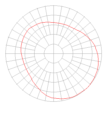 | ||||||||||||||||||
| Azimuth | Ratio | Azimuth | Ratio | Azimuth | Ratio | Azimuth | Ratio | ||||||||||||
| 5 | 0.640 | 15 | 0.640 | 25 | 0.650 | 35 | 0.660 | ||||||||||||
| 45 | 0.690 | 55 | 0.740 | 65 | 0.790 | 75 | 0.850 | ||||||||||||
| 85 | 0.890 | 95 | 0.930 | 105 | 0.960 | 115 | 0.980 | ||||||||||||
| 125 | 0.990 | 135 | 1.000 | 145 | 0.990 | 155 | 0.990 | ||||||||||||
| 165 | 0.970 | 175 | 0.940 | 185 | 0.910 | 195 | 0.850 | ||||||||||||
| 205 | 0.780 | 215 | 0.730 | 225 | 0.680 | 235 | 0.660 | ||||||||||||
| 245 | 0.650 | 255 | 0.650 | 265 | 0.660 | 275 | 0.680 | ||||||||||||
| 285 | 0.690 | 295 | 0.700 | 305 | 0.710 | 315 | 0.720 | ||||||||||||
| 325 | 0.700 | 335 | 0.690 | 345 | 0.670 | 355 | 0.650 | ||||||||||||
Structure Registration Number 1045122 Structure Type: TOWER Registered To: NEW JERSEY PUBLIC BROADCASTING AUTHORITY DBA = NEW JERSEY NETWORK Structure Address: .8 Km Se Of Nj Rt 517 & Sand Pond Rd Int Hardistonville, NJ County Name: Sussex County ASR Issued: 04/27/1998 Date Built: 07/08/1998 Site Elevation: 396 m (1299 ft.) Structure Height: 54.9 m (180 ft.) Height Overall: 61 m (200 ft.) Overall Height AMSL: 457 m (1499 ft.) FAA Determination: 03/27/1998 FAA Study #: 97-AEA-3038-OE Paint & Light FAA Chapters: NONE Removed expiration date from determination. Scenario 1./jjs/case#635066 41-08-37.0 N 74-32-17.0 W (NAD 83) 41-08-36.7 N 74-32-18.4 W (Converted to NAD 27) |
25 South Stockton St. Trenton, NJ 08608 Phone: 609-777-5257 Government Entity | Title: Acting Executive Director, Njpba Date: 08/08/2019 Application Certifier NEW JERSEY PUBLIC BROADCASTING AUTHORITY New Jersey Public Broadcasting Authority 25 South Stockton St. Trenton, NJ 08608 Applicant Jeffrey J DePolo Broadcast Sciences Llc 1240 Horse Shoe Trl Malvern, PA 19355 Sr. Engineer Margaret L Miller Gray Miller Persh Llp 1200 New Hampshire Ave., Nw Suite 410 Washington, DC 20036 RICHARD WILLIAMS New Jersey Public Broadcasting Authority 25 South Stockton St Trenton, NJ 08608 DIRECTOR OF ENGINEERING | |||||||||||||||||