
FCCInfo.com
A Service of Cavell, Mertz & Associates, Inc.
(855) FCC-INFO
|
|
|
RF spectrum relinquished in the spectrum auction Virtual Channel 65 |  |
|
||||||||||||||||||
|
|
WEDY is a channel sharing guest of WEDH, Hartford, Connecticut Repacking Information: Channel 41 was relinquished in the spectrum auction Status: License Application Accepted: 08/16/2019 License Expires: 04/01/2023 File Number: -0000080386 FCC Website Links: LMS Facility Details This Application Other WEDY Applications Including Superseded Applications Mailing Address Correspondence for WEDY Correspondence related to application -0000080386 Service Contour - Open Street Map or USGS Map (41 dBu) Service Contour - KML / Google Earth (41 dBu) Public Inspection Files History Cards for WEDY Rabbit Ears Info Search for WEDY Site Location: 41-42-13.0 N 72-49-55.0 W (NAD 83) Site Location: 41-42-12.6 N 72-49-56.6 W (Converted to NAD 27) ERP: 497 kW Polarization: Elliptically polarized HAAT: 506 m (1660 ft.) Electrical Beam Tilt: 1 degree R/C AGL: 388 m (1273 ft.) R/C AMSL: 604.4 m (1983 ft.) Site Elevation: 216.4 m. (710 ft.) Height Overall*: 408.1 m (1339 ft.) (* As Filed In This Application, may differ from ASR Data, Below.) Directional Antenna - Antenna Make/Model: DIELECTRIC TFU-16DSC/VP-R C170 Antenna ID: 1002375 Polarization: Elliptically polarized | |||||||||||||||||||||
| Antenna Data for Antenna Id: 1002375 WEDY DT File: -0000080386 DIELECTRIC - TFU-16DSC/VP-R C170 Service: DT Standard Pattern: Y | 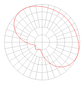 | |||||||||||||||||||||
| Azimuth | Ratio | Azimuth | Ratio | Azimuth | Ratio | Azimuth | Ratio | |||||||||||||||
| 0 | 0.936 | 10 | 0.917 | 20 | 0.905 | 30 | 0.900 | |||||||||||||||
| 40 | 0.899 | 50 | 0.900 | 60 | 0.905 | 70 | 0.917 | |||||||||||||||
| 80 | 0.936 | 90 | 0.963 | 100 | 0.988 | 110 | 1.000 | |||||||||||||||
| 120 | 0.987 | 130 | 0.940 | 140 | 0.854 | 150 | 0.733 | |||||||||||||||
| 160 | 0.588 | 170 | 0.437 | 180 | 0.302 | 190 | 0.218 | |||||||||||||||
| 200 | 0.207 | 210 | 0.232 | 220 | 0.245 | 230 | 0.232 | |||||||||||||||
| 240 | 0.207 | 250 | 0.218 | 260 | 0.302 | 270 | 0.437 | |||||||||||||||
| 280 | 0.588 | 290 | 0.733 | 300 | 0.854 | 310 | 0.940 | |||||||||||||||
| 320 | 0.987 | 330 | 1.000 | 340 | 0.988 | 350 | 0.963 | |||||||||||||||
Structure Registration Number 1041624 Structure Type: Registered To: COMMUNICATIONS SITE MANAGEMENT, LLC Structure Address: 200 Colt Highway Rt. 6 Farmington, CT County Name: Hartford County ASR Issued: 08/24/2015 Date Built: 09/01/1984 Site Elevation: 216.4 m (710 ft.) Structure Height: 393.8 m (1292 ft.) Height Overall: 408.1 m (1339 ft.) Overall Height AMSL: 624.5 m (2049 ft.) FAA Determination: 01/17/1984 FAA Study #: 83-ANE-0395-OE FAA Circular #: 70/7460-1F Paint & Light FAA Chapters: 4, 6, 9 41-42-13.0 N 72-49-55.0 W (NAD 83) 41-42-12.6 N 72-49-56.6 W (Converted to NAD 27) |
1049 Asylum Avenue Hartford, CT 06105 Phone: 860-278-5310 Not-for-Profit | Application Certifier CONNECTICUT PUBLIC TELEVISION Connecticut Public Broadcasting, Inc. 1049 Asylum Avenue Hartford, CT 06105 Applicant STEVEN C SCHAFFER, ESQ Garvey Schubert Barer 1000 Potomac Street, Nw Suite 200 Washington, DC 20007 | ||||||||||||||||||||
| ||||||||||||||||||||||