
FCCInfo.com
A Service of Cavell, Mertz & Associates, Inc.
(855) FCC-INFO
|
|
WYTU-LD from 03/16/2007 |
|
|
||||||||||||||||
|
|
Status: License Application Accepted: 10/07/2019 License Expires: 12/01/2021 File Number: -0000084618 FCC Website Links: LMS Facility Details This Application Other WYTU-LD Applications Including Superseded Applications Mailing Address Correspondence for WYTU-LD Correspondence related to application -0000084618 Service Contour - Open Street Map or USGS Map (51 dBu) Service Contour - KML / Google Earth (51 dBu) Rabbit Ears Info Search for WYTU-LD Site Location: 43-06-42.0 N 87-55-50.0 W (NAD 83) Site Location: 43-06-42.0 N 87-55-49.7 W (Converted to NAD 27) ERP: 7 kW Polarization: Horizontally polarized Electrical Beam Tilt: 1.5 degrees R/C AGL: 313.9 m (1030 ft.) R/C AMSL: 503.8 m (1653 ft.) Emission Mask: Stringent Site Elevation: 189.9 m. (623 ft.) Height Overall*: 373.7 m (1226 ft.) (* As Filed In This Application, may differ from ASR Data, Below.) Directional Antenna - Antenna Make/Model: ATC ATC-BCH616CM-16 Antenna ID: 1005669 Polarization: Horizontally polarized | ||||||||||||||||||
| Antenna Data for Antenna Id: 1005669 WYTU-LD LD File: -0000084618 ATC - ATC-BCH616CM-16 Service: LD Standard Pattern: N Pattern and Field Values Include a 270° Clockwise Rotation | 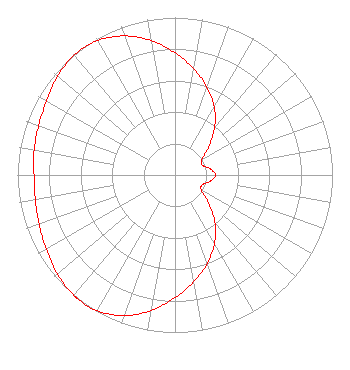 | ||||||||||||||||||
| Azimuth | Ratio | Azimuth | Ratio | Azimuth | Ratio | Azimuth | Ratio | ||||||||||||
| 0 | 0.775 | 10 | 0.684 | 20 | 0.593 | 30 | 0.497 | ||||||||||||
| 40 | 0.392 | 50 | 0.280 | 60 | 0.197 | 70 | 0.184 | ||||||||||||
| 80 | 0.226 | 90 | 0.257 | 100 | 0.227 | 110 | 0.183 | ||||||||||||
| 120 | 0.194 | 130 | 0.278 | 140 | 0.393 | 150 | 0.502 | ||||||||||||
| 160 | 0.599 | 170 | 0.688 | 180 | 0.778 | 190 | 0.873 | ||||||||||||
| 200 | 0.951 | 210 | 0.993 | 217 | 1.000 | 220 | 0.998 | ||||||||||||
| 230 | 0.976 | 240 | 0.944 | 250 | 0.918 | 260 | 0.901 | ||||||||||||
| 270 | 0.895 | 280 | 0.908 | 290 | 0.921 | 300 | 0.942 | ||||||||||||
| 310 | 0.974 | 320 | 0.995 | 330 | 0.985 | 340 | 0.940 | ||||||||||||
| 350 | 0.865 | ||||||||||||||||||
Structure Registration Number 1047092 Structure Type: GTOWER Registered To: WEIGEL BROADCASTING CO. Structure Address: 5201 N Milwaukee River Parkway Milwaukee, WI County Name: Milwaukee County ASR Issued: 09/22/2023 Date Built: 10/03/2023 Site Elevation: 189.6 m (622 ft.) Structure Height: 357 m (1171 ft.) Height Overall: 373.7 m (1226 ft.) Overall Height AMSL: 563.3 m (1848 ft.) FAA Determination: 09/19/2023 FAA Study #: 2023-AGL-15180-OE FAA Circular #: 70/7460-1M Paint & Light FAA Chapters: 3, 4, 5, 15 PRIOR STUDY 1995-AGL-1121-OE 43-06-42.0 N 87-55-50.0 W (NAD 83) 43-06-42.0 N 87-55-49.7 W (Converted to NAD 27) |
26 North Halsted Street Chicago, IL 60661 Phone: 312-705-2600 Limited Partnership | Title: Pres. Sec. Treas. Of General Partner Date: 10/07/2019 Application Certifier CHANNEL 41 AND 63 LIMITED PARTNERSHIP Channel 41 And 63 Limited Partnership 26 North Halsted Street Chicago, IL 60661 Applicant Matthew S. DelNero Covington & Burling Llp One Citycenter, 850 Tenth Street, N.w. Washington, DC 20001 Legal Representative Louis R duTreil, Jr Dutreil Lundin & Rackley Inc 3135 Southgate Circle Sarasota, FL 34239 Technical Consultant | |||||||||||||||||
| |||||||||||||||||||