
FCCInfo.com
A Service of Cavell, Mertz & Associates, Inc.
(855) FCC-INFO
|
|
WILT-LD from 02/25/2010 |
|
|
|||||||||||||||||
|
|
Status: License Application Accepted: 09/13/2019 License Expires: 12/01/2020 File Number: -0000081348 FCC Website Links: LMS Facility Details This Application Other WILT-LD Applications Including Superseded Applications Mailing Address Correspondence for WILT-LD Correspondence related to application -0000081348 Service Contour - Open Street Map or USGS Map (51 dBu) Service Contour - KML / Google Earth (51 dBu) Rabbit Ears Info Search for WILT-LD Site Location: 34-05-52.3 N 77-58-17.2 W (NAD 83) Site Location: 34-05-51.7 N 77-58-18.2 W (Converted to NAD 27) ERP: 15 kW Polarization: Horizontally polarized Electrical Beam Tilt: 1.75 degrees R/C AGL: 133 m (436 ft.) R/C AMSL: 139.7 m (458 ft.) Emission Mask: Full Service Site Elevation: 6.7 m. (22 ft.) Height Overall*: 184.5 m (605 ft.) (* As Filed In This Application, may differ from ASR Data, Below.) Directional Antenna - Antenna Make/Model: Electronics Research Inc. AL8W-33 Antenna ID: 1005549 Polarization: Horizontally polarized
| |||||||||||||||||||
| Antenna Data for Antenna Id: 1005549 WILT-LD LD File: -0000081348 Electronics Research Inc. - AL8W-33 Service: LD Standard Pattern: N | 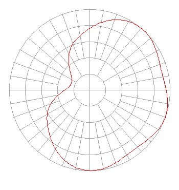 | |||||||||||||||||||
| Azimuth | Ratio | Azimuth | Ratio | Azimuth | Ratio | Azimuth | Ratio | |||||||||||||
| 0 | 0.758 | 10 | 0.845 | 20 | 0.922 | 30 | 0.975 | |||||||||||||
| 40 | 0.997 | 50 | 0.990 | 60 | 0.959 | 70 | 0.929 | |||||||||||||
| 80 | 0.925 | 90 | 0.951 | 100 | 0.985 | 110 | 1.000 | |||||||||||||
| 120 | 0.985 | 130 | 0.951 | 140 | 0.925 | 150 | 0.929 | |||||||||||||
| 160 | 0.959 | 170 | 0.990 | 180 | 0.997 | 190 | 0.975 | |||||||||||||
| 200 | 0.922 | 210 | 0.845 | 220 | 0.758 | 230 | 0.680 | |||||||||||||
| 240 | 0.605 | 250 | 0.510 | 260 | 0.397 | 270 | 0.302 | |||||||||||||
| 280 | 0.253 | 290 | 0.241 | 300 | 0.253 | 310 | 0.302 | |||||||||||||
| 320 | 0.397 | 330 | 0.510 | 340 | 0.605 | 350 | 0.680 | |||||||||||||
Structure Registration Number 1285012 Structure Type: GTOWER Registered To: Capitol Broadcasting Company, Inc. Structure Address: 9016 Funston Road Winnabow, NC County Name: Brunswick County ASR Issued: 09/08/2016 Date Built: 04/05/2013 Site Elevation: 6.7 m (22 ft.) Structure Height: 183.5 m (602 ft.) Height Overall: 184.5 m (605 ft.) Overall Height AMSL: 191.2 m (627 ft.) FAA Determination: 08/28/2012 FAA Study #: 2012-ASO-8272-OE Paint & Light FAA Chapters: CONTINUE AS IS PRIOR STUDY 2011-ASO-516-OE. CHAPTERS 3,4,5,12 CIRCULAR 1K. ADD SPECIAL CONDITION FOR RED LIGHT DEVIATION. 34-05-52.3 N 77-58-17.2 W (NAD 83) 34-05-51.7 N 77-58-18.2 W (Converted to NAD 27) |
2619 Western Blvd Raleigh, NC 27606 Phone: 919-821-8933 Corporation | Title: Vice President Date: 09/13/2019 Application Certifier Capitol Broadcasting Company, Inc. 2619 Western Blvd Raleigh, NC 27606 Applicant Louis R duTreil, Jr Dutreil Lundin & Rackley Inc 3135 Southgate Circle Sarasota, FL 34239 Technical Consultant David A. O'Connor Wilkinson Barker Knauer, Llp 1800 M Street, Nw Suite 800n Washington, DC 20036 Partner | ||||||||||||||||||