
FCCInfo.com
A Service of Cavell, Mertz & Associates, Inc.
(855) FCC-INFO
|
|
WPXR-TV from 01/13/1998 WPXR-TV from 07/11/1983 |
Post-repack Channel 27 Virtual Channel 38 |  |
|
|||||||||||||||
|
|
Repacking Information: Pre-Repack Channel: 36 Post-Repack Channel: 27 Post-Repack ERP: 580 kW Phase: 5 Completion Deadline: 9/11/2019 Upstream/Downstream Dependencies Other Linked Stations Find nearby TV Facilities Status: License Application Accepted: 09/16/2019 License Expires: 10/01/2020 File Number: -0000081460 FCC Website Links: LMS Facility Details This Application Other WPXR-TV Applications Including Superseded Applications Mailing Address Correspondence for WPXR-TV Correspondence related to application -0000081460 Service Contour - Open Street Map or USGS Map (41 dBu) Service Contour - KML / Google Earth (41 dBu) Public Inspection Files Rabbit Ears Info Search for WPXR-TV Site Location: 37-11-56.0 N 80-09-00.0 W (NAD 83) Site Location: 37-11-55.5 N 80-09-00.9 W (Converted to NAD 27) ERP: 609 kW Polarization: Elliptically polarized HAAT: 623.6 m (2046 ft.) Electrical Beam Tilt: 1 degree R/C AGL: 61.8 m (203 ft.) R/C AMSL: 1207.8 m (3963 ft.) Site Elevation: 1146 m. (3760 ft.) Height Overall*: 74.5 m (244 ft.) (* As Filed In This Application, may differ from ASR Data, Below.) Directional Antenna - Antenna Make/Model: DIELECTRIC TFU-24GTH/VP-R S180 Antenna ID: 1005553 Polarization: Elliptically polarized | ||||||||||||||||||
| Antenna Data for Antenna Id: 1005553 WPXR-TV DT File: -0000081460 DIELECTRIC - TFU-24GTH/VP-R S180 Service: DT Standard Pattern: N | 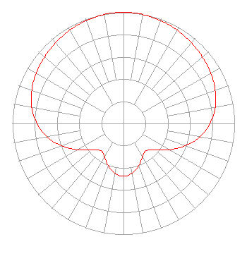 | ||||||||||||||||||
| Azimuth | Ratio | Azimuth | Ratio | Azimuth | Ratio | Azimuth | Ratio | ||||||||||||
| 0 | 1.000 | 10 | 0.996 | 20 | 0.985 | 30 | 0.968 | ||||||||||||
| 40 | 0.949 | 50 | 0.928 | 60 | 0.906 | 70 | 0.878 | ||||||||||||
| 80 | 0.839 | 90 | 0.780 | 100 | 0.697 | 110 | 0.591 | ||||||||||||
| 120 | 0.474 | 130 | 0.369 | 140 | 0.319 | 150 | 0.343 | ||||||||||||
| 160 | 0.403 | 170 | 0.455 | 180 | 0.475 | 190 | 0.455 | ||||||||||||
| 200 | 0.403 | 210 | 0.343 | 220 | 0.319 | 230 | 0.369 | ||||||||||||
| 240 | 0.474 | 250 | 0.591 | 260 | 0.697 | 270 | 0.780 | ||||||||||||
| 280 | 0.839 | 290 | 0.878 | 300 | 0.906 | 310 | 0.928 | ||||||||||||
| 320 | 0.949 | 330 | 0.968 | 340 | 0.985 | 350 | 0.996 | ||||||||||||
Structure Registration Number 1028319 Structure Type: Registered To: ION Station Properties, LLC Structure Address: Atop Poor Mountain Roanoke, VA County Name: Roanoke County ASR Issued: 12/20/2019 Date Built: 10/06/1986 Site Elevation: 1146 m (3760 ft.) Structure Height: 54.7 m (179 ft.) Height Overall: 74.5 m (244 ft.) Overall Height AMSL: 1220.5 m (4004 ft.) FAA Determination: 07/29/1997 FAA Study #: 97-AEA-0748-OE FAA Circular #: 70/7460-1J Paint & Light FAA Chapters: 3, 4, 5, 13 37-11-56.0 N 80-09-00.0 W (NAD 83) 37-11-55.5 N 80-09-00.9 W (Converted to NAD 27) |
312 Walnut Street 28th Floor Cincinnati, OH 45202 Phone: 513-977-3000 Limited Liability Company | Title: Vp, Engineering Date: 09/16/2019 Application Certifier ION MEDIA LICENSE COMPANY, LLC Ion Media License Company, Llc 601 Clearwater Park Road West Palm Beach, FL 33401 Applicant Shea Clark Ion Media Networks, Inc. 14444 66th Street N Clearwater, FL 33764 VP, Engineering Bianca Frye Ion Media Networks, Inc. 601 Clearwater Park Road West Palm Beach, FL 33401 Paralegal | |||||||||||||||||