
FCCInfo.com
A Service of Cavell, Mertz & Associates, Inc.
(855) FCC-INFO
|
|
|
|
|
|||||||||||||||||
|
|
Status: License Application Accepted: 11/08/2019 License Expires: 08/01/2022 File Number: -0000088509 FCC Website Links: LMS Facility Details This Application Other KLBB-LD Applications Including Superseded Applications Mailing Address Correspondence for KLBB-LD Correspondence related to application -0000088509 Service Contour - Open Street Map or USGS Map (51 dBu) Service Contour - KML / Google Earth (51 dBu) Rabbit Ears Info Search for KLBB-LD Site Location: 33-30-08.3 N 101-52-21.3 W (NAD 83) Site Location: 33-30-08.0 N 101-52-19.7 W (Converted to NAD 27) ERP: 15 kW Polarization: Horizontally polarized Electrical Beam Tilt: 1.5 degrees R/C AGL: 271.3 m (890 ft.) R/C AMSL: 1248.8 m (4097 ft.) Emission Mask: Full Service Site Elevation: 977.5 m. (3207 ft.) Height Overall*: 297.2 m (975 ft.) (* As Filed In This Application, may differ from ASR Data, Below.) Directional Antenna - Antenna Make/Model: R.F. Systems SBB-16C160 Antenna ID: 1005923 Polarization: Horizontally polarized
| |||||||||||||||||||
| Antenna Data for Antenna Id: 1005923 KLBB-LD LD File: -0000088509 R.F. Systems - SBB-16C160 Service: LD Standard Pattern: N | 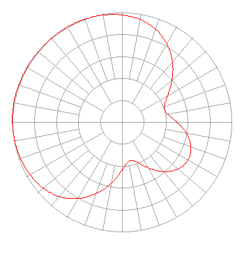 | |||||||||||||||||||
| Azimuth | Ratio | Azimuth | Ratio | Azimuth | Ratio | Azimuth | Ratio | |||||||||||||
| 0 | 0.976 | 10 | 0.949 | 20 | 0.898 | 30 | 0.819 | |||||||||||||
| 40 | 0.714 | 50 | 0.595 | 60 | 0.481 | 70 | 0.410 | |||||||||||||
| 80 | 0.420 | 90 | 0.499 | 100 | 0.595 | 110 | 0.668 | |||||||||||||
| 120 | 0.694 | 130 | 0.666 | 140 | 0.589 | 150 | 0.482 | |||||||||||||
| 160 | 0.385 | 170 | 0.362 | 180 | 0.439 | 190 | 0.566 | |||||||||||||
| 200 | 0.695 | 210 | 0.805 | 220 | 0.886 | 230 | 0.937 | |||||||||||||
| 240 | 0.965 | 250 | 0.981 | 260 | 0.992 | 270 | 0.998 | |||||||||||||
| 280 | 1.000 | 290 | 0.998 | 300 | 0.996 | 310 | 0.996 | |||||||||||||
| 320 | 0.997 | 330 | 0.998 | 340 | 0.995 | 350 | 0.989 | |||||||||||||
Structure Registration Number 1248244 Structure Type: GTOWER Registered To: FLP Ramar, Ltd. Structure Address: 100th & University Lubbock, TX County Name: Lubbock County ASR Issued: 10/27/2017 Date Built: 12/08/2006 Site Elevation: 977.5 m (3207 ft.) Structure Height: 295.7 m (970 ft.) Height Overall: 297.2 m (975 ft.) Overall Height AMSL: 1274.7 m (4182 ft.) FAA Determination: 08/02/2017 FAA Study #: 2017-ASW-7973-OE FAA Circular #: 70/7460-1K Paint & Light FAA Chapters: 4, 9, 12 OM&L to remain the same as prior study = A HIGH-DUAL SYSTEM 33-30-08.3 N 101-52-21.3 W (NAD 83) 33-30-08.0 N 101-52-19.7 W (Converted to NAD 27) |
4370 Peachtree Road, Ne Atlanta, GA 30319 Phone: 404-504-9828 Corporation | Title: President Date: 11/08/2019 Application Certifier Ramar Communications, Inc. P.o. Box 3757 Lubbock, TX 79452 Applicant Winn Boedeker Ramar Communications, Inc. Po Box 3757 Lubbock, TX 79452 Director of Engineering DENNIS P CORBETT, ESQ Telecommunications Law Professionals Pllc 1025 Connecticut Ave, Nw Suite 1011 Washington, DC 20036 Joseph M. Davis, P.E. Chesapeake Rf Consultants, Llc 207 Old Dominion Road Yorktown, VA 23692 Consulting Engineer | ||||||||||||||||||