
FCCInfo.com
A Service of Cavell, Mertz & Associates, Inc.
(855) FCC-INFO
|
|
WNGX-LD from 07/13/1998 WNGX-LD from 01/18/1996 |
|
|
||||||||||||||||
|
|
Status: License Application Accepted: 09/26/2019 License Expires: 06/01/2023 File Number: -0000082224 FCC Website Links: LMS Facility Details This Application Other WNGX-LD Applications Including Superseded Applications Mailing Address Correspondence for WNGX-LD Correspondence related to application -0000082224 Service Contour - Open Street Map or USGS Map (51 dBu) Service Contour - KML / Google Earth (51 dBu) Rabbit Ears Info Search for WNGX-LD Site Location: 43-01-12.2 N 73-31-26.4 W (NAD 83) Site Location: 43-01-11.9 N 73-31-28.0 W (Converted to NAD 27) ERP: 15 kW Polarization: Horizontally polarized R/C AGL: 20 m (66 ft.) R/C AMSL: 451.3 m (1481 ft.) Emission Mask: Full Service Site Elevation: 431.3 m. (1415 ft.) Height Overall*: 34.7 m (114 ft.) (* As Filed In This Application, may differ from ASR Data, Below.) Directional Antenna - Antenna Make/Model: NIC (4) BKU 2@50 2@310 Antenna ID: 1002599 Polarization: Horizontally polarized | ||||||||||||||||||
| Antenna Data for Antenna Id: 1002599 WNGX-LD LD File: -0000082224 NIC - (4) BKU 2@50 2@310 Service: LD Standard Pattern: Y Pattern and Field Values Include a 270° Clockwise Rotation | 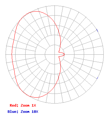 | ||||||||||||||||||
| Azimuth | Ratio | Azimuth | Ratio | Azimuth | Ratio | Azimuth | Ratio | ||||||||||||
| 0 | 0.650 | 10 | 0.480 | 20 | 0.350 | 30 | 0.250 | ||||||||||||
| 40 | 0.170 | 50 | 0.130 | 60 | 0.100 | 70 | 0.120 | ||||||||||||
| 80 | 0.170 | 90 | 0.200 | 100 | 0.170 | 110 | 0.120 | ||||||||||||
| 120 | 0.100 | 130 | 0.130 | 140 | 0.170 | 150 | 0.250 | ||||||||||||
| 160 | 0.350 | 170 | 0.480 | 180 | 0.650 | 190 | 0.810 | ||||||||||||
| 200 | 0.930 | 210 | 0.990 | 220 | 1.000 | 230 | 0.970 | ||||||||||||
| 240 | 0.920 | 250 | 0.880 | 260 | 0.870 | 270 | 0.870 | ||||||||||||
| 280 | 0.870 | 290 | 0.880 | 300 | 0.920 | 310 | 0.970 | ||||||||||||
| 320 | 1.000 | 330 | 0.990 | 340 | 0.930 | 350 | 0.810 | ||||||||||||
Structure Registration Number 1211139 Structure Type: TOWER Registered To: Adirondack Two-Way Radio, Inc. Structure Address: Willard Mountain 1.5 Mi Ne Of Easton, NY County Name: Washington County ASR Issued: 04/03/2000 Date Built: 05/15/2001 Site Elevation: 431.3 m (1415 ft.) Structure Height: 30.5 m (100 ft.) Height Overall: 34.7 m (114 ft.) Overall Height AMSL: 466 m (1529 ft.) FAA Determination: 12/07/1999 FAA Study #: 99-AEA-3475-OE Paint & Light FAA Chapters: NONE 43-01-12.2 N 73-31-26.4 W (NAD 83) 43-01-11.9 N 73-31-28.0 W (Converted to NAD 27) |
Buskirk, NY 12028 Phone: 518-686-0975 Individual | Title: Licensee Date: 09/26/2019 Application Certifier 65 King Road Buskirk, NY 12028 Applicant Lee G Petro Pillsbury Winthrop Shaw Pittman 1200 Seventeenth Street, N.w. Washington, DC 20036 Richard C Goetz R & L Media Systems 135 N Country Club Dr Hendersonville, TN 37075 Broadcast Consultant | |||||||||||||||||