
FCCInfo.com
A Service of Cavell, Mertz & Associates, Inc.
(855) FCC-INFO
|
|
|
Post-repack Channel 20 Virtual Channel 55 |  |
|
|||||||||||||||
|
|
Repacking Information: Pre-Repack Channel: 36 Post-Repack Channel: 20 Post-Repack ERP: 707 kW Phase: 6 Completion Deadline: 10/18/2019 Upstream/Downstream Dependencies Other Linked Stations Find nearby TV Facilities Status: License Application Accepted: 10/21/2019 License Expires: 08/01/2021 File Number: -0000086952 FCC Website Links: LMS Facility Details This Application Other WFFT-TV Applications Including Superseded Applications Mailing Address Correspondence for WFFT-TV Correspondence related to application -0000086952 Service Contour - Open Street Map or USGS Map (41 dBu) Service Contour - KML / Google Earth (41 dBu) Public Inspection Files History Cards for WFFT-TV Rabbit Ears Info Search for WFFT-TV Site Location: 41-06-33.4 N 85-11-42.2 W (NAD 83) Site Location: 41-06-33.2 N 85-11-42.3 W (Converted to NAD 27) ERP: 550 kW Polarization: Elliptically polarized HAAT: 239.9 m (787 ft.) Electrical Beam Tilt: 0.75 degrees R/C AGL: 239.3 m (785 ft.) R/C AMSL: 489.5 m (1606 ft.) Site Elevation: 250.2 m. (821 ft.) Height Overall*: 245.7 m (806 ft.) (* As Filed In This Application, may differ from ASR Data, Below.) Directional Antenna - Antenna Make/Model: Electronics Research Inc. ATW15H3-ETTX-20H Antenna ID: 1005800 Polarization: Elliptically polarized | ||||||||||||||||||
| Antenna Data for Antenna Id: 1005800 WFFT-TV DT File: -0000086952 Electronics Research Inc. - ATW15H3-ETTX-20H Service: DT Standard Pattern: N | 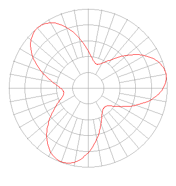 | ||||||||||||||||||
| Azimuth | Ratio | Azimuth | Ratio | Azimuth | Ratio | Azimuth | Ratio | ||||||||||||
| 0 | 0.470 | 10 | 0.360 | 20 | 0.320 | 30 | 0.360 | ||||||||||||
| 40 | 0.470 | 50 | 0.640 | 60 | 0.820 | 70 | 0.950 | ||||||||||||
| 80 | 1.000 | 90 | 0.950 | 100 | 0.820 | 110 | 0.640 | ||||||||||||
| 120 | 0.470 | 130 | 0.350 | 140 | 0.320 | 150 | 0.360 | ||||||||||||
| 160 | 0.480 | 170 | 0.650 | 180 | 0.820 | 190 | 0.950 | ||||||||||||
| 200 | 0.990 | 210 | 0.940 | 220 | 0.810 | 230 | 0.640 | ||||||||||||
| 240 | 0.470 | 250 | 0.350 | 260 | 0.310 | 270 | 0.350 | ||||||||||||
| 280 | 0.460 | 290 | 0.630 | 300 | 0.810 | 310 | 0.940 | ||||||||||||
| 320 | 0.990 | 330 | 0.950 | 340 | 0.820 | 350 | 0.640 | ||||||||||||
Structure Registration Number 1034986 Structure Type: GTOWER Registered To: American Towers LLC Structure Address: 3707 Hillegas Road (#051402) Fort Wayne, IN County Name: Allen County ASR Issued: 01/11/2023 Date Built: 08/28/1979 Site Elevation: 250.2 m (821 ft.) Structure Height: 234.4 m (769 ft.) Height Overall: 245.7 m (806 ft.) Overall Height AMSL: 495.9 m (1627 ft.) FAA Determination: 01/03/2023 FAA Study #: 2022-AGL-4781-OE FAA Circular #: 70/7460-1M Paint & Light FAA Chapters: 4, 9, 15 OM&L to remain the same as prior study = A HIGH-DUAL SYSTEM 41-06-33.4 N 85-11-42.2 W (NAD 83) 41-06-33.2 N 85-11-42.3 W (Converted to NAD 27) |
300 Interstate N. Parkway Atlanta, GA 30339 Phone: 770-226-2000 Limited Liability Company | Title: Ceo Date: 10/21/2019 Application Certifier Ft. Wayne Tv License Company, Llc 3282 Northside Parkway Suite 275 Atlanta, GA 30327 Applicant John M. Burgett Wiley Rein Llp 1776 K Street, N.w. Washington, DC 20006 FCC Counsel Joseph M. Davis, P.E Chesapeake Rf Consultants, Llc 207 Old Dominion Road Yorktown, VA 23692 Consulting Engineer | |||||||||||||||||