
FCCInfo.com
A Service of Cavell, Mertz & Associates, Inc.
(855) FCC-INFO
|
|
WUVN from 08/29/1979 |
RF spectrum relinquished in the spectrum auction Virtual Channel 18 |
|
||||||||||||||||
|
|
WUVN is a channel sharing guest of WUTH-CD, Hartford, Connecticut Repacking Information: Channel 46 was relinquished in the spectrum auction Status: License Application Accepted: 10/18/2019 License Expires: 04/01/2023 File Number: -0000086825 FCC Website Links: LMS Facility Details This Application Other WUVN Applications Including Superseded Applications Mailing Address Correspondence for WUVN Correspondence related to application -0000086825 Service Contour - Open Street Map or USGS Map (41 dBu) Service Contour - KML / Google Earth (41 dBu) Public Inspection Files History Cards for WUVN Rabbit Ears Info Search for WUVN Site Location: 41-42-30.0 N 72-28-32.0 W (NAD 83) Site Location: 41-42-29.6 N 72-28-33.7 W (Converted to NAD 27) ERP: 15 kW Polarization: Horizontally polarized R/C AGL: 38 m (125 ft.) R/C AMSL: 274.7 m (901 ft.) Emission Mask: Full Service Site Elevation: 236.7 m. (777 ft.) Height Overall*: 71 m (233 ft.) (* As Filed In This Application, may differ from ASR Data, Below.) Directional Antenna - Antenna Make/Model: DIELECTRIC TUA-C4SP-4/7M-1-SM Antenna ID: 1002324 Polarization: Horizontally polarized | ||||||||||||||||||
| Antenna Data for Antenna Id: 1002324 WUVN DT File: -0000086825 DIELECTRIC - TUA-C4SP-4/7M-1-SM Service: DT Standard Pattern: Y Pattern and Field Values Include a 295° Clockwise Rotation | 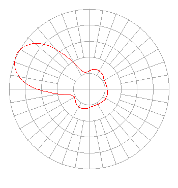 | ||||||||||||||||||
| Azimuth | Ratio | Azimuth | Ratio | Azimuth | Ratio | Azimuth | Ratio | ||||||||||||
| 5 | 0.235 | 15 | 0.255 | 25 | 0.260 | 35 | 0.255 | ||||||||||||
| 45 | 0.245 | 55 | 0.225 | 65 | 0.220 | 75 | 0.220 | ||||||||||||
| 85 | 0.225 | 95 | 0.230 | 105 | 0.240 | 115 | 0.240 | ||||||||||||
| 125 | 0.240 | 135 | 0.230 | 145 | 0.225 | 155 | 0.220 | ||||||||||||
| 165 | 0.220 | 175 | 0.225 | 185 | 0.245 | 195 | 0.255 | ||||||||||||
| 205 | 0.260 | 215 | 0.255 | 225 | 0.235 | 235 | 0.215 | ||||||||||||
| 245 | 0.215 | 255 | 0.280 | 265 | 0.500 | 275 | 0.790 | ||||||||||||
| 285 | 0.950 | 295 | 1.000 | 305 | 0.950 | 315 | 0.790 | ||||||||||||
| 325 | 0.500 | 335 | 0.280 | 345 | 0.215 | 355 | 0.215 | ||||||||||||
Structure Registration Number 1206978 Structure Type: TOWER Registered To: M&R Gassner Family III, LLC Structure Address: 50 Birchmountain Rd Glastonbury, CT County Name: Hartford County ASR Issued: 02/01/2017 Date Built: 12/03/1999 Site Elevation: 236.7 m (777 ft.) Structure Height: 67 m (220 ft.) Height Overall: 71 m (233 ft.) Overall Height AMSL: 307.7 m (1010 ft.) FAA Determination: 11/24/1999 FAA Study #: 99-ANE-0572-OE FAA Circular #: 70/7460-1J Paint & Light FAA Chapters: 3, 4, 5, 13 PRIOR FAA 96-ANE-0318-OE 41-42-30.0 N 72-28-32.0 W (NAD 83) 41-42-29.6 N 72-28-33.7 W (Converted to NAD 27) |
2425 Olympic Blvd Ste 6000 W Santa Monica, CA 90404 Phone: 310-447-3870 Limited Liability Company | Application Certifier Entravision Holdings, Llc 2425 Olympic Blvd Ste 6000 W Santa Monica, CA 90404 Applicant W JEFFREY REYNOLDS Du Treil, Lundin & Rackley, Inc. 3135 Southgate Circle Sarasota, FL 34239 TECHNICAL CONSULTANT | |||||||||||||||||