
FCCInfo.com
A Service of Cavell, Mertz & Associates, Inc.
(855) FCC-INFO
|
|
K18NE-D from 08/17/2009 K18NE-D from 12/07/2004 |
|
|
||||||||||||||||
|
|
Status: License Application Accepted: 11/06/2019 License Expires: 04/01/2022 File Number: -0000088224 FCC Website Links: LMS Facility Details This Application Other K18NE-D Applications Including Superseded Applications Mailing Address Correspondence for K18NE-D Correspondence related to application -0000088224 Service Contour - Open Street Map or USGS Map (51 dBu) Service Contour - KML / Google Earth (51 dBu) Rabbit Ears Info Search for K18NE-D Site Location: 44-06-28.0 N 94-35-56.0 W (NAD 83) Site Location: 44-06-28.1 N 94-35-55.1 W (Converted to NAD 27) ERP: 0.6 kW Polarization: Horizontally polarized R/C AGL: 181 m (594 ft.) R/C AMSL: 495.6 m (1626 ft.) Emission Mask: Stringent Site Elevation: 314.6 m. (1032 ft.) Height Overall*: 186.5 m (612 ft.) (* As Filed In This Application, may differ from ASR Data, Below.) Directional Antenna - Antenna Make/Model: MICRO COMMUNICATIONS INC 955116 Antenna ID: 20051 Polarization: Horizontally polarized | ||||||||||||||||||
| Antenna Data for Antenna Id: 20051 K18NE-D LD File: -0000088224 MICRO COMMUNICATIONS INC - 955116 Service: LD Standard Pattern: Y | 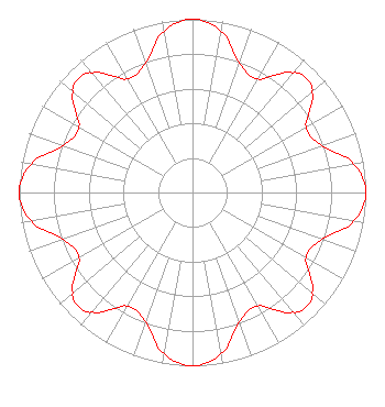 | ||||||||||||||||||
| Azimuth | Ratio | Azimuth | Ratio | Azimuth | Ratio | Azimuth | Ratio | ||||||||||||
| 0 | 1.000 | 10 | 0.947 | 20 | 0.793 | 30 | 0.756 | ||||||||||||
| 40 | 0.902 | 45 | 0.933 | 50 | 0.902 | 60 | 0.756 | ||||||||||||
| 70 | 0.793 | 80 | 0.947 | 90 | 1.000 | 100 | 0.947 | ||||||||||||
| 110 | 0.793 | 120 | 0.756 | 130 | 0.902 | 135 | 0.933 | ||||||||||||
| 140 | 0.902 | 150 | 0.756 | 160 | 0.793 | 170 | 0.947 | ||||||||||||
| 180 | 1.000 | 190 | 0.947 | 200 | 0.793 | 210 | 0.756 | ||||||||||||
| 220 | 0.902 | 225 | 0.933 | 230 | 0.902 | 240 | 0.756 | ||||||||||||
| 250 | 0.793 | 260 | 0.947 | 270 | 1.000 | 280 | 0.947 | ||||||||||||
| 290 | 0.793 | 300 | 0.756 | 310 | 0.902 | 315 | 0.933 | ||||||||||||
| 320 | 0.902 | 330 | 0.756 | 340 | 0.793 | 350 | 0.947 | ||||||||||||
Structure Registration Number 1024448 Structure Type: 2TOWER Registered To: COOPERATIVE TELEVISION OF SOUTHERN MINNESOTA DBA = BROWN COUNTY RURAL ELECTRIC ASSOCIATION Structure Address: 3.2 Km E Godahl, MN County Name: Watonwan County ASR Issued: 07/28/1997 Date Built: 01/01/1980 Site Elevation: 314.6 m (1032 ft.) Structure Height: 186.5 m (612 ft.) Height Overall: 186.5 m (612 ft.) Overall Height AMSL: 501.1 m (1644 ft.) FAA Determination: 09/24/1980 FAA Study #: 80-GL-1233-OE Paint & Light FAA Chapters: 1, 3, 5, 14, 21 RED LIGHTS/PAINT 44-06-28.0 N 94-35-56.0 W (NAD 83) 44-06-28.1 N 94-35-55.1 W (Converted to NAD 27) |
Mankato, MN 56002 Phone: 507-387-7963 Not-for-Profit | Title: Manager Date: 11/06/2019 Application Certifier Cooperative Television Association Of Southern Minnesota Mankato, MN 56002 Applicant Darryl K. DeLawder Delawder Communications, Inc. Ashburn, VA 20146 President Shelley Sadowsky Shelley Sadowsky, Llc 5938 Dorchester Way Rockville, MD 20852 Counsel Tom Uppman Uppman Technical Services, Inc. 27408 Scenic Byway Rd. Belle Plaine, MN 56011 TECHNICAL CONSULTANT Thomas Uppman Uppman Technical Services, Inc. 27408 Scenic Byway Road Belle Plaine, MN 56011 Technical Consultant | |||||||||||||||||
| |||||||||||||||||||