
FCCInfo.com
A Service of Cavell, Mertz & Associates, Inc.
(855) FCC-INFO
|
|
WANN-CD from 07/31/2007 |
Post-repack Channel 20 |
|
||||||||||||||||
|
|
Repacking Information: Pre-Repack Channel: 29 Post-Repack Channel: 20 Post-Repack ERP: 11.4 kW Phase: 5 Completion Deadline: 9/11/2019 Upstream/Downstream Dependencies Other Linked Stations Find nearby TV Facilities Status: License Application Accepted: 12/04/2019 License Expires: 04/01/2021 File Number: -0000092680 FCC Website Links: LMS Facility Details This Application Other WANN-CD Applications Including Superseded Applications Mailing Address Correspondence for WANN-CD Correspondence related to application -0000092680 Service Contour - Open Street Map or USGS Map (51 dBu) Service Contour - KML / Google Earth (51 dBu) Public Inspection Files Rabbit Ears Info Search for WANN-CD Site Location: 33-48-26.4 N 84-20-21.5 W (NAD 83) Site Location: 33-48-26.0 N 84-20-21.8 W (Converted to NAD 27) ERP: 11.4 kW Polarization: Horizontally polarized Electrical Beam Tilt: 0.75 degrees R/C AGL: 351 m (1152 ft.) R/C AMSL: 615.3 m (2019 ft.) Emission Mask: Stringent Site Elevation: 264.3 m. (867 ft.) Height Overall*: 360.3 m (1182 ft.) (* As Filed In This Application, may differ from ASR Data, Below.) Directional Antenna - Antenna Make/Model: R.F. Systems RD280 Antenna ID: 94292 Polarization: Horizontally polarized | ||||||||||||||||||
| Antenna Data for Antenna Id: 94292 WANN-CD DC File: -0000092680 R.F. Systems - RD280 Service: DC Standard Pattern: Y | 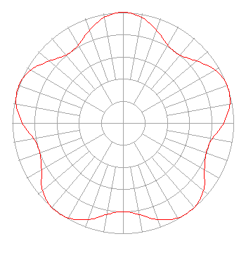 | ||||||||||||||||||
| Azimuth | Ratio | Azimuth | Ratio | Azimuth | Ratio | Azimuth | Ratio | ||||||||||||
| 0 | 1.000 | 10 | 0.970 | 20 | 0.890 | 30 | 0.810 | ||||||||||||
| 40 | 0.800 | 50 | 0.870 | 60 | 0.960 | 70 | 1.000 | ||||||||||||
| 80 | 0.980 | 90 | 0.910 | 100 | 0.820 | 110 | 0.800 | ||||||||||||
| 120 | 0.850 | 130 | 0.950 | 140 | 1.000 | 150 | 0.990 | ||||||||||||
| 160 | 0.930 | 170 | 0.840 | 180 | 0.800 | 190 | 0.840 | ||||||||||||
| 200 | 0.930 | 210 | 0.990 | 220 | 1.000 | 230 | 0.950 | ||||||||||||
| 240 | 0.850 | 250 | 0.800 | 260 | 0.820 | 270 | 0.910 | ||||||||||||
| 280 | 0.980 | 290 | 1.000 | 300 | 0.960 | 310 | 0.870 | ||||||||||||
| 320 | 0.800 | 330 | 0.810 | 340 | 0.890 | 350 | 0.970 | ||||||||||||
Structure Registration Number 1223132 Structure Type: GTOWER Registered To: American Towers LLC Structure Address: 1800 Briarcliff Road Ne (#282650) Atlanta, GA County Name: DeKalb County ASR Issued: 07/11/2023 Date Built: 03/27/2002 Site Elevation: 264.3 m (867 ft.) Structure Height: 321.9 m (1056 ft.) Height Overall: 360.3 m (1182 ft.) Overall Height AMSL: 624.6 m (2049 ft.) FAA Determination: 11/02/2021 FAA Study #: 2021-ASO-36490-OE FAA Circular #: 70/7460-1M Paint & Light FAA Chapters: 4, 9, 15 33-48-26.4 N 84-20-21.5 W (NAD 83) 33-48-26.0 N 84-20-21.8 W (Converted to NAD 27) |
1498 Buford Hwy Ste C 275 Sugar Hill, GA 30518 Phone: 770-771-1644 Corporation | Title: President Date: 12/04/2019 Application Certifier PRISM BROADCASTING NETWORK, INC. Prism Broadcasting Network, Inc. 7742 Spalding Dr. Suite 475 Norcross, GA 30092 Applicant Susan Hansen B. W. St. Clair 2305 Vida Shaw Rd New Iberia, LA 70563 CONSULTANT | |||||||||||||||||