
FCCInfo.com
A Service of Cavell, Mertz & Associates, Inc.
(855) FCC-INFO
|
|
WZTD-LD from 01/16/2008 WZTD-LD from 02/22/2000 WZTD-LD from 12/09/1991 |
|
|
||||||||||||||||
|
|
Status: License Application Accepted: 12/12/2019 License Expires: 10/01/2020 File Number: -0000093220 FCC Website Links: LMS Facility Details This Application Other WZTD-LD Applications Including Superseded Applications Mailing Address Correspondence for WZTD-LD Correspondence related to application -0000093220 Service Contour - Open Street Map or USGS Map (51 dBu) Service Contour - KML / Google Earth (51 dBu) Rabbit Ears Info Search for WZTD-LD Site Location: 37-30-45.6 N 77-36-04.8 W (NAD 83) Site Location: 37-30-45.1 N 77-36-05.8 W (Converted to NAD 27) ERP: 15 kW Polarization: Elliptically polarized Electrical Beam Tilt: 1.7 degrees R/C AGL: 150.9 m (495 ft.) R/C AMSL: 260 m (853 ft.) Emission Mask: Full Service Site Elevation: 109.1 m. (358 ft.) Height Overall*: 374.5 m (1229 ft.) (* As Filed In This Application, may differ from ASR Data, Below.) Directional Antenna - Antenna Make/Model: DIELECTRIC TLP-12C/VP Antenna ID: 1006075 Polarization: Elliptically polarized | ||||||||||||||||||
| Antenna Data for Antenna Id: 1006075 WZTD-LD LD File: -0000093220 DIELECTRIC - TLP-12C/VP Service: LD Standard Pattern: N Pattern and Field Values Include a 55° Clockwise Rotation | 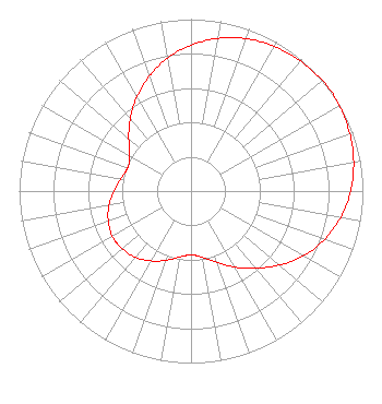 | ||||||||||||||||||
| Azimuth | Ratio | Azimuth | Ratio | Azimuth | Ratio | Azimuth | Ratio | ||||||||||||
| 5 | 0.877 | 15 | 0.924 | 25 | 0.958 | 35 | 0.980 | ||||||||||||
| 45 | 0.994 | 55 | 1.000 | 65 | 0.990 | 75 | 0.973 | ||||||||||||
| 85 | 0.946 | 95 | 0.907 | 105 | 0.857 | 115 | 0.792 | ||||||||||||
| 125 | 0.713 | 135 | 0.628 | 145 | 0.547 | 155 | 0.474 | ||||||||||||
| 165 | 0.414 | 175 | 0.378 | 179 | 0.373 | 181 | 0.373 | ||||||||||||
| 185 | 0.378 | 195 | 0.408 | 205 | 0.449 | 215 | 0.487 | ||||||||||||
| 225 | 0.515 | 235 | 0.527 | 237 | 0.528 | 245 | 0.522 | ||||||||||||
| 255 | 0.500 | 265 | 0.467 | 275 | 0.430 | 285 | 0.400 | ||||||||||||
| 290 | 0.393 | 291 | 0.393 | 295 | 0.398 | 305 | 0.440 | ||||||||||||
| 315 | 0.510 | 325 | 0.590 | 335 | 0.671 | 345 | 0.748 | ||||||||||||
| 355 | 0.818 | ||||||||||||||||||
Structure Registration Number 1018227 Structure Type: GTOWER Registered To: SpectraSite Communications, LLC. through American Towers, LLC. Structure Address: 5 Sesame Street (310418) Richmond, VA County Name: Chesterfield County ASR Issued: 10/22/2013 Date Built: 02/20/2008 Site Elevation: 109.1 m (358 ft.) Structure Height: 276.7 m (908 ft.) Height Overall: 374.5 m (1229 ft.) Overall Height AMSL: 483.6 m (1587 ft.) FAA Determination: 09/04/2013 FAA Study #: 2013-AEA-4072-OE FAA Circular #: 70/7460-1J Paint & Light FAA Chapters: 4, 7, 13 PRIOR STUDY 2012-AEA-1925-OE OM&L WHITE - HIGH INTENSITY (STYLE C) 37-30-45.6 N 77-36-04.8 W (NAD 83) 37-30-45.1 N 77-36-05.8 W (Converted to NAD 27) |
300 New Jersey Avenue, Nw Suite 700 Washington, DC 20001 Phone: 202-524-6401 Limited Liability Company | Title: Assistant Secretary Date: 12/12/2019 Application Certifier Nbc Telemundo License Llc 300 New Jersey Avenue, Nw Suite 700 Washington, DC 20001 Applicant H. Douglas Lung Nbcuniversal, Llc Honomu, HI 96728 Corporate Engineering Manager Margaret L. Tobey Nbc Telemundo License Llc 300 New Jersey Avenue, Nw Suite 700 Washington, DC 20001 Assistant Secretary | |||||||||||||||||