
FCCInfo.com
A Service of Cavell, Mertz & Associates, Inc.
(855) FCC-INFO
|
|
WHOI from 02/01/1985 WHOI from 02/02/1985 |
Post-repack Channel 24 Virtual Channel 19 |  |
|
||||||||||||||||||
|
|
Repacking Information: Pre-Repack Channel: 19 Post-Repack Channel: 24 Post-Repack ERP: 219 kW Phase: 7 Completion Deadline: 1/17/2020 Upstream/Downstream Dependencies Other Linked Stations Find nearby TV Facilities Status: License Application Accepted: 01/27/2020 License Expires: 12/01/2021 File Number: -0000100514 FCC Website Links: LMS Facility Details This Application Other WHOI Applications Including Superseded Applications Mailing Address Correspondence for WHOI Correspondence related to application -0000100514 Service Contour - Open Street Map or USGS Map (41 dBu) Service Contour - KML / Google Earth (41 dBu) Public Inspection Files History Cards for WHOI Rabbit Ears Info Search for WHOI Site Location: 40-37-46.0 N 89-32-53.0 W (NAD 83) Site Location: 40-37-45.9 N 89-32-52.6 W (Converted to NAD 27) ERP: 402 kW Polarization: Horizontally polarized HAAT: 211.6 m (694 ft.) Electrical Beam Tilt: 0.75 degrees R/C AGL: 173.5 m (569 ft.) R/C AMSL: 400.6 m (1314 ft.) Site Elevation: 227.1 m. (745 ft.) Height Overall*: 184.1 m (604 ft.) (* As Filed In This Application, may differ from ASR Data, Below.) Directional Antenna - Antenna Make/Model: Dielectric TUA-O4-16/64H-1-T-R Antenna ID: 1006311 Polarization: Horizontally polarized | |||||||||||||||||||||
| Antenna Data for Antenna Id: 1006311 WHOI DT File: -0000100514 Dielectric - TUA-O4-16/64H-1-T-R Service: DT Standard Pattern: N | 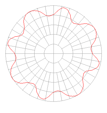 | |||||||||||||||||||||
| Azimuth | Ratio | Azimuth | Ratio | Azimuth | Ratio | Azimuth | Ratio | |||||||||||||||
| 0 | 0.810 | 10 | 0.949 | 14 | 0.970 | 20 | 0.921 | |||||||||||||||
| 30 | 0.765 | 40 | 0.795 | 50 | 0.948 | 60 | 1.000 | |||||||||||||||
| 70 | 0.937 | 80 | 0.797 | 90 | 0.810 | 100 | 0.949 | |||||||||||||||
| 104 | 0.970 | 110 | 0.921 | 120 | 0.765 | 130 | 0.795 | |||||||||||||||
| 140 | 0.948 | 150 | 1.000 | 160 | 0.937 | 170 | 0.797 | |||||||||||||||
| 180 | 0.810 | 190 | 0.949 | 194 | 0.970 | 200 | 0.921 | |||||||||||||||
| 210 | 0.765 | 220 | 0.795 | 230 | 0.948 | 240 | 1.000 | |||||||||||||||
| 250 | 0.937 | 260 | 0.797 | 270 | 0.810 | 280 | 0.949 | |||||||||||||||
| 284 | 0.970 | 290 | 0.921 | 300 | 0.765 | 310 | 0.795 | |||||||||||||||
| 320 | 0.948 | 330 | 1.000 | 340 | 0.937 | 350 | 0.797 | |||||||||||||||
Structure Registration Number 1008775 Structure Type: TOWER Registered To: Gray Media Group, Inc. Structure Address: 2907 E Springfield Rd East Peoria, IL County Name: Tazewell County ASR Issued: 08/03/2021 Date Built: 01/01/1964 Site Elevation: 227.1 m (745 ft.) Structure Height: 147.5 m (484 ft.) Height Overall: 184.1 m (604 ft.) Overall Height AMSL: 411.2 m (1349 ft.) Paint & Light FAA Chapters: 1, 3, 5, 14, 21 40-37-46.0 N 89-32-53.0 W (NAD 83) 40-37-45.9 N 89-32-52.6 W (Converted to NAD 27) |
1200 17th Street, Nw Washington, DC 20063 Phone: 202-663-8195 Limited Liability Company | Title: Cfo Date: 01/27/2020 Application Certifier WHOI LICENSEE, LLC Whoi Licensee, Llc 10706 Beaver Dam Road Cockeysville, MD 21030 Applicant Paul A. Cicelski, Esq Lerman Senter Pllc 2001 L Street Nw Suite 400 Washington, DC 20036 Scott Turpie Lohnes & Culver, Llc Alexandria, VA 22302 Technical Consultant | ||||||||||||||||||||
|
| |||||||||||||||||||||