
FCCInfo.com
A Service of Cavell, Mertz & Associates, Inc.
(855) FCC-INFO
|
|
K21OM-D from 06/02/2010 |
|
|
||||||||||||||||
|
|
Status: License Application Accepted: 02/12/2020 License Expires: 06/01/2021 File Number: -0000105971 FCC Website Links: LMS Facility Details This Application Other K21OM-D Applications Including Superseded Applications Mailing Address Correspondence for K21OM-D Correspondence related to application -0000105971 Service Contour - Open Street Map or USGS Map (51 dBu) Service Contour - KML / Google Earth (51 dBu) Rabbit Ears Info Search for K21OM-D Site Location: 30-10-59.8 N 92-21-49.9 W (NAD 83) Site Location: 30-10-59.1 N 92-21-49.4 W (Converted to NAD 27) ERP: 13 kW Polarization: Circularly polarized Electrical Beam Tilt: .75 degrees R/C AGL: 111.2 m (365 ft.) R/C AMSL: 117.6 m (386 ft.) Emission Mask: Full Service Site Elevation: 6.4 m. (21 ft.) Height Overall*: 143.3 m (470 ft.) (* As Filed In This Application, may differ from ASR Data, Below.) Directional Antenna - Antenna Make/Model: Kathrein ATCBCH312O- V0-21 Antenna ID: Polarization: Circularly polarized | ||||||||||||||||||
| Antenna Data for Antenna Id: K21OM-D LD File: -0000105971 Kathrein - ATCBCH312O- V0-21 Service: LD Standard Pattern: N Pattern and Field Values Include a 108° Clockwise Rotation | 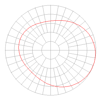 | ||||||||||||||||||
| Azimuth | Ratio | Azimuth | Ratio | Azimuth | Ratio | Azimuth | Ratio | ||||||||||||
| 8 | 0.662 | 18 | 0.692 | 28 | 0.733 | 38 | 0.780 | ||||||||||||
| 48 | 0.829 | 58 | 0.876 | 68 | 0.918 | 78 | 0.953 | ||||||||||||
| 88 | 0.979 | 98 | 0.995 | 108 | 1.000 | 118 | 0.995 | ||||||||||||
| 128 | 0.979 | 138 | 0.953 | 148 | 0.918 | 158 | 0.876 | ||||||||||||
| 168 | 0.829 | 178 | 0.780 | 188 | 0.733 | 198 | 0.692 | ||||||||||||
| 208 | 0.662 | 218 | 0.644 | 228 | 0.639 | 238 | 0.646 | ||||||||||||
| 248 | 0.661 | 258 | 0.678 | 268 | 0.694 | 278 | 0.705 | ||||||||||||
| 288 | 0.709 | 298 | 0.705 | 308 | 0.694 | 318 | 0.678 | ||||||||||||
| 328 | 0.661 | 338 | 0.646 | 348 | 0.639 | 358 | 0.644 | ||||||||||||
Structure Registration Number 1021697 Structure Type: GTOWER Registered To: Pinnacle Towers LLC Structure Address: 8023 S La Highway 13 Crowley, LA County Name: Acadia Parish ASR Issued: 05/06/2016 Date Built: 05/14/2010 Site Elevation: 6.4 m (21 ft.) Structure Height: 140.2 m (460 ft.) Height Overall: 143.3 m (470 ft.) Overall Height AMSL: 149.7 m (491 ft.) FAA Determination: 05/15/2015 FAA Study #: 2015-ASW-3117-OE FAA Circular #: 70/7460-1K Paint & Light FAA Chapters: 4, 8, 12 PRIOR STUDY 2010-ASW-2719-OE 30-10-59.8 N 92-21-49.9 W (NAD 83) 30-10-59.1 N 92-21-49.4 W (Converted to NAD 27) |
295 Madison Avenue, 12th Floor New York, NY 10017 Phone: 954-606-5486 Corporation | Title: Chief Operating Officer Date: 02/12/2020 Application Certifier Dtv America Corporation 450 Park Avenue 30th Floor New York, NY 10022 Applicant REBECCA HANSON Hc2 Broadcasting Holdings, Inc. 450 Park Ave 30th Fl New York, NY 10022 EVP and General Counsel KURT HANSON Hc2 Broadcasting Holdings, Inc. 450 Park Ave 30th Fl New York, NY 10022 CHIEF TECHNOLOGY OFFICER Renee Ilhardt Hc2 Broadcasting Holdings, Inc. 450 Park Ave 30th Fl New York, NY 10022 | |||||||||||||||||